Cortes Island facts for kids

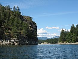
The Gorge of Cortes Island
|
|

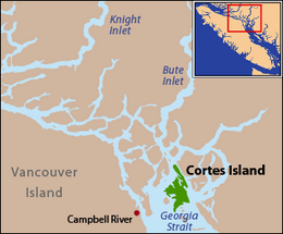
Cortes Island is located at the northern end of the Strait of Georgia
|
|
| Geography | |
|---|---|
| Location | Salish Sea |
| Coordinates | 50°07′N 124°58′W / 50.117°N 124.967°W |
| Archipelago | Discovery Islands |
| Area | 130 km2 (50 sq mi) |
| Length | 25 km (15.5 mi) |
| Width | 13 km (8.1 mi) |
| Administration | |
| Province | British Columbia |
| Regional district | Strathcona |
| Demographics | |
| Population | 1,035 (2016) |
| Ethnic groups | Wei Wai Kai, Kwiakah, Homalco and Klahoose First Nations |
Cortes Island is a beautiful island in British Columbia, Canada. It's part of a group of islands called the Discovery Islands. The island is about 25 kilometers (15 miles) long and 13 kilometers (8 miles) wide. Its total area is 130 square kilometers (50 square miles). About 1,035 people live there permanently (as of 2016). Cortes Island is managed by the Strathcona Regional District, which helps with things like water, fire safety, and parks.
You can get to Cortes Island by plane or by ferry. Seaplanes land in its calm harbors. Ferries come from Quadra Island, which you can reach from Vancouver Island by BC Ferries. Many people visit Cortes Island in the summer. They come to enjoy the peaceful feeling and warm weather.
History
The Klahoose First Nation has an office on Cortes Island. This shows their long history and connection to the land. Other First Nations, like the Wei Wai Kai, Kwiakah, and Homalco, also have strong ties to this area.
The island got its name in 1792. Spanish explorers Galiano and Valdés named it after Hernán Cortés. He was a famous Spanish conqueror of Mexico. Even though the official spelling is Cortes, many early settlers called it Cortez.
Another nearby island, Marina Island, was also named in 1792. It was named after La Malinche, also known as Doña Marina. She was a Nahua woman who helped Hernán Cortés as an interpreter and advisor. For a while, Marina Island was called Mary Island on maps, but its original name was brought back in 1906.
In July 1792, explorers William Broughton and Archibald Menzies from the Vancouver Expedition visited Cortes Island. They landed at a stream in Squirrel Cove. They were surprised to find the stream was salty. They also saw some large birds and deer during their visit.
Geography
Cortes Island is part of the Discovery Islands in British Columbia, Canada. These islands are located beyond the northern end of the Gulf of Georgia. They lie between Vancouver Island and the mainland of British Columbia. Cortes Island is also sometimes considered part of the Northern Gulf Islands.
The island is separated from Quadra Island by Sutil Channel. To the northeast, across Lewis Channel, is West Redonda Island. Desolation Sound is to the east of Cortes Island. Beyond that is the upper part of the Malaspina Peninsula. Cortes Island is located about halfway between the cities of Powell River and Campbell River.
Climate
Cortes Island has a mild climate. Summers are generally warm and pleasant. Winters are cool, but not usually extremely cold. The island gets a good amount of rain, especially in the fall and winter months. Snowfall is not very common, but it does happen sometimes in winter. This climate helps the island's beautiful nature thrive.
Communities and Life on the Island
Cortes Island is part of the Strathcona Regional District. This district helps manage local services for the island.
Communities
Several communities are found on Cortes Island. These include Cortes Bay, Whaletown, Squirrel Cove, and Mansons Landing. Each community has its own unique feel. Desolation Sound is a beautiful area located off the east shore of the island.
Historically, people on the island worked in forestry, fishing, and mining. Today, the island is also known for its peaceful atmosphere. You can find a campground at Smelt Bay Provincial Park.
The Campbell River School District runs the Cortes Elementary / Jr. Secondary school on the island. This school teaches students up to grade 9. After grade 9, students usually either learn at home or go to a school off the island.
During the summer, a special Canadian Coast Guard Inshore Rescue Boat Station opens in Cortes Bay. This station helps keep people safe on the water. It has a boat and a small crew ready to respond to emergencies.
Tourism
Cortes Island is famous for its wild and natural beauty. Many visitors come to enjoy the quiet and remote feel of the community.
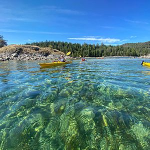
Kayaking is a very popular activity around the island. People love to explore the coastline by kayak. The Cortes Museum and Archives is a great place to learn about the island's history. It also has the local visitor's center, where you can get information for your trip.
Craft markets are held every week. You can find them at the Manson's Landing Community Hall and the Gorge Harbour Marina Resort. These markets are a fun way to see local crafts and meet people. Hiking is another popular activity. Trails through K'was park and Carrington Bay offer amazing views and a chance to explore nature.
 | Charles R. Drew |
 | Benjamin Banneker |
 | Jane C. Wright |
 | Roger Arliner Young |


