Desolation Sound facts for kids
Quick facts for kids Desolation Sound |
|
|---|---|
| French: Baie Desolation | |

Desolation Sound
|
|

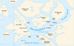
Extent of Desolation Sound
|
|
| Location | Discovery Islands, British Columbia |
| Coordinates | 50°07′20″N 124°45′30″W / 50.12222°N 124.75833°W |
| Type | Sound |
| Part of | Salish Sea |
| Islands | Kinghorn Island, Martin Islands, Mink Island, Protection Island, Station Island |
| Settlements | Refuge Cove |
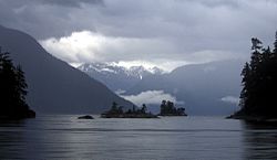
Desolation Sound (also known as French: Baie Desolation in French) is a beautiful, deep waterway located in British Columbia, Canada. It's found at the northern tip of the Salish Sea and the Sunshine Coast. This area is famous for its calm waters and stunning natural beauty, making it a popular spot for boating and outdoor adventures.
Contents
Exploring Desolation Sound
Desolation Sound is a large area of ocean surrounded by islands and mainland. It's a special place where the ocean meets the land, creating many hidden coves and channels. This sound is a favorite destination for people who love to explore by boat or kayak.
Where is Desolation Sound?
The sound is surrounded by several islands, including Cortes Island, East Redonda Island, and West Redonda Island. Nearby waterways include Lewis Channel to the northwest and Homfray Channel to the east. To the south, it connects to the larger Strait of Georgia.
Parks and Nature
Many provincial parks protect the natural beauty of Desolation Sound. These parks are great places to visit and enjoy nature. Some of the main parks include:
- Desolation Sound Marine Provincial Park
- Malaspina Provincial Park
- Okeover Arm Provincial Park
- Roscoe Bay Provincial Park
History of the Sound
Long before Europeans arrived, the area of Desolation Sound was home to Indigenous peoples. Tribes like the K'ómoks, Klahoose First Nation, Tla'amin Nation, and Hamalco First Nations lived here for thousands of years. Their traditions and history are deeply connected to this land and water.
European Exploration
In the summer of 1792, two groups of explorers arrived in the sound. They were led by Captains George Vancouver from Britain and Dionisio Alcalá Galiano and Cayetano Valdés y Flores from Spain. They worked together to map the area. Captain Vancouver gave the sound its name, "Desolation Sound." He said that there was "not a single prospect that was pleasing to the eye," though many people today would disagree!
Life in Desolation Sound
While Desolation Sound is mostly wild, there is one small community.
Refuge Cove
Refuge Cove is the only community located directly within Desolation Sound. It's found on West Redonda Island. This small community is a very important stop for boaters and fishers. It provides supplies and a place to rest for those exploring the sound.
Local Jobs
The main ways people make a living in Desolation Sound are:
- Shellfish farming: Growing oysters, clams, and other shellfish.
- Forestry: Working with the forests and trees.
- Ecotourism: Guiding visitors who want to enjoy nature responsibly.
Getting to Desolation Sound
If you want to visit Desolation Sound, there are a few ways to get there.
By Car and Ferry
You can take a BC Ferries boat from Vancouver or Courtenay to Powell River. From Powell River, it's a short drive north to a town called Lund.
By Boat or Kayak
From Lund, you can travel by boat or kayak to reach the beautiful Copeland Islands and Desolation Sound itself. This includes areas like Desolation Sound Marine Provincial Park and Malaspina Provincial Park.
Popular Anchorages
Boaters often stop at special, protected spots called anchorages. Some of the well-known anchorages in Desolation Sound include:
- Gorge Harbour (on Cortes Island)
- Grace Harbour
- Prideaux Haven (a cove on Homfray Channel)
- Refuge Cove
- Tenedos Bay
 | Madam C. J. Walker |
 | Janet Emerson Bashen |
 | Annie Turnbo Malone |
 | Maggie L. Walker |


