East Redonda Island facts for kids

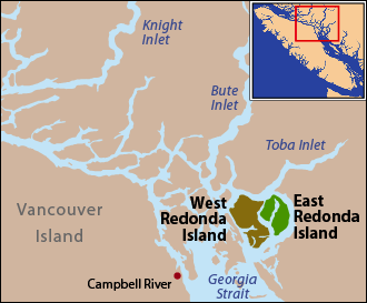
East and West Redonda Islands are located just north of Desolation Sound, near the mouth of Toba Inlet.
|
|
| Geography | |
|---|---|
| Location | Salish Sea |
| Coordinates | 50°14′N 124°43′W / 50.233°N 124.717°W |
| Highest elevation | 1,591 m (5,220 ft) |
| Highest point | Mount Addenbroke |
| Administration | |
| Province | British Columbia |
| Regional district | Strathcona |
East Redonda Island is a cool coastal island found in British Columbia, Canada. It's part of a group of islands called the Discovery Islands. This island is located just north of Desolation Sound Marine Park. It's also near the entrance of Toba Inlet.
Island History
In 1792, two Spanish explorers, Galiano and Valdés, discovered East Redonda Island. They named it Isla Redonda, which means "round island" in Spanish.
Island Geography
East Redonda Island is separated from a bigger island, West Redonda Island, by a waterway called Waddington Channel. On its eastern side, a deep channel named Homfray Channel separates it from the mainland.
A long, narrow inlet called Pendrell Sound cuts into the island from Waddington Channel. It stretches towards the northeast. At the northern tip of the island, you'll find Pryce Channel.
The shape of East Redonda Island is a bit like Orcas Island. Orcas Island is part of the San Juan Islands in Washington, USA.
Highest Point
The tallest spot on East Redonda Island is Mount Addenbroke. It stands at 1,591 meters (5,220 feet) high.
Nature and Conservation
The eastern part of East Redonda Island is a special protected area. It is called the "East Redonda Island Ecological Reserve." This reserve was set up to study forests and how trees grow. It covers about 6,212 hectares (15,350 acres) of land.
 | William Lucy |
 | Charles Hayes |
 | Cleveland Robinson |

