
Salish Sea facts for kids
Quick facts for kids Salish Sea |
|
|---|---|
| French: Mer des Salish | |

The Salish Sea, showing the open Pacific Ocean at lower left, and from there, heading inland: the Strait of Juan de Fuca, the narrow Puget Sound at lower right, and the wide Strait of Georgia at upper center. Sediment from the Fraser River is visible as a greenish plume in the Strait of Georgia.
|
|

Salish Sea
Location in British Columbia
|
|
| Location | British Columbia and Washington |
| Coordinates | 48°56′12″N 123°03′40″W / 48.93667°N 123.06111°W |
| River sources | Fraser, Nisqually, Nooksack, Puyallup, Skagit, Snohomish and Squamish Rivers |
| Ocean/sea sources | Pacific Ocean |
| Catchment area | 110,000 km2 (42,000 sq mi) |
| Basin countries | Canada and United States |
| Surface area | 18,000 km2 (6,900 sq mi) |
| Average depth | 130 m (430 ft) |
| Max. depth | 670 m (2,200 ft) |
| Residence time | 110 days |
| Settlements | Seattle, Vancouver, Surrey, Tacoma, Victoria, Everett, Nanaimo |
The Salish Sea (say "SAY-lish") is a large body of water on the Pacific coast of North America. It is located between the Canadian province of British Columbia and the U.S. state of Washington. This sea is made up of several important parts: the Strait of Georgia, the Strait of Juan de Fuca, and Puget Sound. It also includes many smaller channels and waterways that connect them.
The Salish Sea stretches a long way, from the Discovery Islands in the north to Budd Inlet in the south. It is partly separated from the huge Pacific Ocean by Vancouver Island and the Olympic Peninsula. Many big cities are located along the shores of the Salish Sea. These include Vancouver, Seattle, Tacoma, Everett, Bellingham, Port Angeles, and Victoria.
Contents
What's in a Name?
Why is it called the Salish Sea?
The name Salish Sea was first used in 1988 by a marine biologist named Bert Webber. He was from Bellingham, Washington. He wanted a name that would bring together the waters of the Strait of Georgia, Puget Sound, and Strait of Juan de Fuca. He hoped this new name would help people care more about the region's waters and the amazing plants and animals that live there. Thanks to his efforts, the name is now officially recognized in both Canada and the U.S.
The Coast Salish People

The Coast Salish are the native people who have lived in this area for thousands of years. They live in southwest British Columbia and northwest Washington, along the Salish Sea. These groups share similar languages and cultures. The Coast Salish are part of a larger group called Salishan or Salish. There are 23 different Salish languages.
European explorers first met Salishan people in the late 1700s. The waterways of the Salish Sea were very important for trade among the Coast Salish. Even today, the sea provides food and other resources for these native communities.
When did the name become official?
In 2008, a First Nation group in Canada suggested making "Salish Sea" an official name. A similar idea was also being discussed in the United States. Both countries worked together to make it happen.
- In August 2009, British Columbia approved the name.
- In October 2009, Washington State approved it.
- On November 12, 2009, the United States Board on Geographic Names officially approved it.
- In February 2010, the British Columbia Geographical Names Office also made it official.
The French name Mer des Salish is also an official name in Canada. Even though the name is official, a survey in 2019 showed that many people living near the Salish Sea still don't know its name.
Geography of the Salish Sea
.jpg)

The Salish Sea is about 440 kilometers (273 miles) long. Its total surface area is about 18,000 square kilometers (6,950 square miles). This is about the same size as the Gulf of Riga in Northern Europe.
The sea includes:
- The Strait of Georgia (6,400 km2 or 2,471 mi2)
- The Strait of Juan de Fuca (4,400 km2 or 1,699 mi2)
- Puget Sound (2,500 km2 or 965 mi2)
- And many other smaller bodies of water.
The Salish Sea is about 130 meters (427 feet) deep on average. Its deepest point is 670 meters (2,200 feet) in Jervis Inlet.
Where does the water come from?
The land area that drains into the Salish Sea is huge, about 110,000 square kilometers (42,471 square miles). This is more than six times the size of the sea itself! Many major rivers flow into the Salish Sea. These include the Fraser River, Nisqually River, Nooksack River, Puyallup River, Skagit River, Snohomish River, and Squamish River.
Freshwater from these rivers mixes with salty ocean water from the Strait of Juan de Fuca. This creates different levels of saltiness in the sea. The Fraser River is the biggest source of freshwater. It pours a huge amount of water into the sea, especially during spring and summer.
Islands of the Salish Sea
.jpg)
The Salish Sea has more than 400 islands! Most of these islands belong to one of three main groups:
- The Discovery Islands
- The Gulf Islands
- The San Juan Islands
Whidbey Island in Washington is the largest and most populated island. It covers about 437 square kilometers (169 square miles). Bainbridge Island, also in Washington, has the most people living close together. On the Canadian side, Texada Island is the largest, but it has fewer people.
How the Salish Sea was Formed
The Salish Sea sits in a large dip in the land called the Georgia Depression. This depression formed when huge continental plates crashed into each other about 150 million years ago.
Later, giant sheets of ice, called the Cordilleran Ice Sheet, moved across the land. This happened between 19,000 and 16,000 years ago. As the ice melted and moved back, it carved out the landscape. Then, seawater filled in these carved-out areas, creating the Salish Sea we see today.
Amazing Animals and Plants
The Salish Sea is a lively home for many different kinds of marine life. It has brackish (slightly salty) water that is rich in nutrients. This makes it a great place for many species to live and grow.
Marine Plants

The Salish Sea has many types of kelp, which are large seaweeds. Kelp forests provide excellent homes for many sea creatures. The biggest kelp species here are bull kelp and giant kelp.
You can also find many eelgrass meadows in the shallower parts of the sea. These underwater "grasslands" are important nurseries for young fish and other animals.
Marine Animals

The Salish Sea is home to 253 different kinds of fish! These include many types of hagfish, lampreys, and sharks.
It also has 37 different kinds of marine mammals. Some of the most famous are Steller sea lions, humpback whales, and orcas.
- Transient orcas (which eat other mammals) are slowly increasing in number.
- Southern resident orcas (which eat fish, especially salmon) are struggling. Their population is very low because there aren't enough salmon for them to eat. In 2019, there were only 73 of these whales left.
- Good news for humpback whales! In 2021, a record 21 humpback calves were seen in Salish waters. This means their population might be growing!
- Sea otters are also being seen more often in the Strait of Juan de Fuca.
Glass Sponge Reefs
The waters of the Salish Sea are perfect for special structures called glass sponge reefs. Scientists once thought these reefs had died out long ago. But in 1987, many living glass sponge reefs were discovered off the coast of British Columbia! These reefs are very important for science and the environment. Because of this, all known glass sponge reefs in the Salish Sea are protected. This means fishing activities that could harm them are not allowed.
Images for kids
-
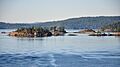
Forested islets and small islands of the Southern Gulf Islands
See also
 In Spanish: Mar de los Salish para niños
