
Jervis Inlet facts for kids
Quick facts for kids Jervis Inlet |
|
|---|---|
| French: Baie Jervis | |

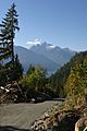
Mount Frederick William & the "elbow" of the inlet
|
|

Jervis Inlet
Location in British Columbia
|
|

Map of Jervis Inlet
|
|
| Location | British Columbia, Canada |
| Coordinates | 49°55′25″N 123°58′27″W / 49.92361°N 123.97417°W |
| Type | Fjord |
| Part of | Salish Sea |
| Max. length | 89 km (55 mi) |
| Max. depth | 670 m (2,200 ft) |
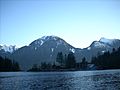
Jervis Inlet (pronounced JAR-viss) is a long, narrow arm of the sea, also known as a fjord. It's located on the coast of British Columbia, Canada. This beautiful inlet is about 95 kilometers (59 miles) northwest of Vancouver. It's one of the main inlets along this part of the coast.
What is Jervis Inlet?
Jervis Inlet stretches for 89 kilometers (55 miles). It starts where the short Skwawka River flows into it. The inlet then opens up into the Strait of Georgia near Texada Island. It is the deepest fjord on the British Columbia coast. At its deepest point, it goes down an amazing 670 meters (2,200 feet)! That's taller than many skyscrapers!
The inlet has three main sections, which are like long arms:
The Queens Reach is at the very top of the inlet. It makes a sharp right turn, which is common in fjords. After this turn, it becomes the Princess Royal Reach. Both of these sections are about 20 kilometers (12 miles) long.
The mountains and valleys around the inlet are home to some of Canada's tallest waterfalls. These include James Bruce Falls, which drops 840 meters (2,756 feet), and Alfred Creek Falls, falling 700 meters (2,297 feet). Imagine seeing water tumble down from such heights!
Exploring Nearby Areas
One of the most popular spots nearby is Princess Louisa Inlet. Here you'll find the Malibu Club and a Young Life Camp. These are located near the Malibu Rapids, which is the entrance to the inlet. At the very end of Princess Louisa Inlet is the Princess Louisa Marine Provincial Park, famous for its stunning Chatterbox Falls.
A ferry operated by BC Ferries connects the areas around Jervis Inlet. It links Earls Cove on the lower Sunshine Coast with Saltery Bay on the upper Sunshine Coast. This ferry helps people travel between these beautiful coastal communities.
Not many people live directly on the shores of Jervis Inlet. There are no main roads that go into the area. The main jobs here include small-scale fish farming (aquaculture), commercial fishing, and logging. In the future, more projects that generate electricity from water power are expected to start up.
A Look Back in Time: History
The area at the head of Jervis Inlet was once a seasonal home for one of the groups that make up today's Shishalh First Nation. They called this place xénichen.
The inlet was named by George Vancouver. He was on an expedition between 1791 and 1795, looking for the famous Northwest Passage. Following the traditions of the Royal Navy, Vancouver named this important waterway after his friend, Rear Admiral Sir John Jervis. This was to honor Jervis's big win over the Spanish fleet in 1797 at Cape St. Vincent in Portugal. Vancouver also named St. Vincent's Bay, near the entrance of Jervis Inlet, after the battle location.
In the 1860s, a survey ship called HMS Plumper explored and mapped the area. During this survey, many places were named after members of Queen Victoria's family. This is how the three main arms of the inlet got their names: Princess Louisa Inlet, Queens Reach, Princess Royal Reach, and Prince of Wales Reach. Many of the mountains in the area were also named during this time, including:
- Mount Alfred
- Mount Frederick William
- Mount Arthur
- Mount Wellington
- Mount Alice
- Mount Victoria
- Mount Helena
- Mount Albert
In the early 1900s, logging and commercial fishing became important industries in the Jervis Inlet area. Large logging camps were set up in places like Goliath Bay and Vancouver Bay. Fishermen from nearby towns like Egmont and Pender Harbour would catch fish. There were also several plants that processed fish in these towns.
Gallery
- Jervis Inlet Gallery
-
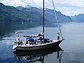
A sailboat explores Princess Royal Reach of the Jervis Inlet.
-
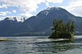
Mount Arthur and Mount Frederick William from the entrance of the Princess Louisa Inlet.
-
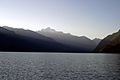
Jervis Inlet at dusk.
-
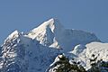
Mount Alfred seen from the inlet.
-
Mount Alfred from a logging road along the inlet.
-
Mount Arthur rising above the Jervis Inlet


See also
 In Spanish: Jervis Inlet para niños
