
Mount Arthur (British Columbia) facts for kids
Quick facts for kids Mount Arthur |
|
|---|---|

Mt. Arthur
|
|
| Highest point | |
| Elevation | 1,619 m (5,312 ft) |
| Prominence | 255 m (837 ft) |
| Parent peak | Mount Wellington |
| Geography | |

Mount Arthur
Location in British Columbia
|
|
| Location | NE of Powell River, New Westminster Land District, British Columbia, Canada |
| Parent range | Pacific Ranges |
| Topo map | NTS 92/J4 |
Mount Arthur is a tall mountain found in British Columbia, Canada. It stands proudly in the Coast Mountains, which are a huge chain of mountains along the Pacific coast. This mountain is a part of the Pacific Ranges, a specific section of the Coast Mountains. It's located near a long, narrow arm of the ocean called the Jervis Inlet.
Contents
Mount Arthur: A Mountain in British Columbia
Mount Arthur reaches a height of 1,619 meters (about 5,312 feet) above sea level. It is a significant peak in its area. The mountain is part of a larger group of peaks in the New Westminster Land District. This district is a historical land division in British Columbia.
Where is Mount Arthur?
Mount Arthur is located in the southwestern part of British Columbia. It sits northeast of a town called Powell River. The mountain overlooks the Queen Reach arm of the Jervis Inlet. This inlet is a deep fjord, which is a long, narrow sea inlet between high cliffs. Fjords are often carved by glaciers.
How Mount Arthur Got Its Name
Mount Arthur was named a long time ago, in the 1860s. A British ship called the HMS Plumper was exploring and mapping the coast of British Columbia. The crew of the HMS Plumper named many places during their survey. They decided to name this mountain after Prince Arthur William Patrick.
Prince Arthur was a member of the British Royal Family. He was the seventh son of Queen Victoria and Prince Albert of England. Naming mountains and other landmarks after royal family members was a common practice during that time. It was a way to honor them and mark the British presence in the area.
Images for kids
- Mount Arthur Gallery
-
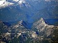
Mt. Arthur is next to Mt Wellington with McConnell Lake center foreground.

