Powell River, British Columbia facts for kids
Quick facts for kids
Powell River
|
|
|---|---|
| City of Powell River | |

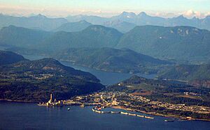
Powell River Mill and townsite area of Powell River. The river runs from Powell Lake (background) to the mill.
|
|
| Country | Canada |
| Province | British Columbia |
| Region | Sunshine Coast |
| Regional District | qathet Regional District |
| Established | 1912 |
| Incorporated | 1955 |
| Reincorporated as a City | 2005 |
| Area | |
| • City | 28.91 km2 (11.16 sq mi) |
| • Metro | 800.72 km2 (309.16 sq mi) |
| Elevation | 50 m (164 ft) |
| Population
(2016)
|
|
| • City | 13,157 |
| • Density | 444.1/km2 (1,150/sq mi) |
| • Metro | 16,783 |
| • Metro density | 21.0/km2 (54/sq mi) |
| District pop = 20,070 | |
| Time zone | UTC−08:00 (PST) |
| • Summer (DST) | UTC−07:00 (PDT) |
| Forward sortation area |
V8A
|
| Area code(s) | 604, 778, 236, 672 |
Powell River is a city located on the northern Sunshine Coast in southwestern British Columbia, Canada. Most people live near the eastern shores of Malaspina Strait. This strait is part of the larger Georgia Strait, which lies between Vancouver Island and the mainland.
Powell River is a bit isolated because of two long, steep-sided fjords. These fjords make it hard to build a direct road connection to Vancouver in the south. Even though it's fairly close to Vancouver, these natural barriers make it feel remote. The city is also home to the main office of the qathet Regional District.
Contents
History of Powell River
The Powell River was named after Israel Wood Powell. He was British Columbia's first superintendent for Indian Affairs. He traveled along the coast of BC in 1881, and the river and lake were named after him.
Powell supported British Columbia joining Canada. He brought the first Canadian flag to BC on June 17, 1871.
Starting the Pulp Mill and Townsite
The pulp mill in Powell River began in 1908. A company town was started in 1910 to support the mill workers. The first roll of paper was made at the Powell River Mill in 1912. Before this, large logging companies moved in to use the huge trees.
The Brooks brothers and M.J. Scanlon formed the Powell River Company. This was western Canada's first pulp and paper mill. The historic townsite was named a National Historic Site of Canada in 1995. It was recognized for being a well-preserved example of an early 20th-century planned community. This community followed the Garden City Design Movement and the Arts and Crafts philosophy.
First Credit Union in British Columbia
In 1939, a group of millworkers started a study club. They got the first charter for a credit union in British Columbia. They began with a deposit of $48.30. The mill gave them a small office space for very low rent.
By 1955, the Powell River Credit Union (now called 'First Credit Union') moved into its own office. It had over 3,000 members and $1 million in assets.
The Mill's Importance and Changes
The mill in Powell River was once the largest pulp and paper mill in the world. At its busiest, one out of every 25 newspapers globally was printed on paper from this mill. However, production has been greatly reduced since then. It now produces newsprint and special papers for Catalyst Paper.
In 2019, Paper Excellence Group bought Catalyst Paper. In 2023, the mill stopped operating permanently.
New Focus for the Economy
After the mill's changes, the local economy started to focus on other areas. These include ecotourism (travel that helps nature) and the arts. Traditional activities like mining, fishing, and forestry are still important.
In 2004, Powell River was named a "Cultural Capital of Canada." This was because of its strong arts and cultural programs.
Tla'amin Nation History
The Powell River area is the home of the Tla'amin Nation. They are part of the Mainland Comox branch of the Coast Salish peoples. They still live there today. Their village is often called Sliammon, which is an English version of Tla'amin.
Name Change Discussion
In May 2021, the Tla'amin Nation asked the Powell River city council to change the city's name. This request came because the city's namesake, Israel Powell, played a role in policies that harmed Indigenous communities. These policies included the sale of land that was part of the tiyskʷat village. He also oversaw the removal of children from their homes to be sent to residential schools. Additionally, he was involved in banning traditional Indigenous customs like the potlatch and their languages.
Sports Teams in Powell River
Powell River is home to several sports teams.
- The Powell River Kings are a team in the British Columbia Hockey League.
- The Powell River Regals are a Senior Men's hockey team. They started in 1955 and have won 3 national championships.
- The Powell River Villa plays in the Vancouver Island Soccer League.
The city also has many youth sports teams and groups.
- PRMHA is the minor hockey association with house and rep teams.
- Powell River's youth baseball league is called the PRMBA. It has divisions for kids aged 5 to 18.
- Powell River's gymnastics association has trained many skilled gymnasts.
Attractions and Activities
In 2020, Powell River received a grant from the government of British Columbia. This money helps support tourism in the town.
Nearby Islands and Outdoor Fun
Nearby, Texada Island offers quiet beaches and lakes. It's a popular weekend spot for people living in Powell River. Both Texada Island and Powell River are great for:
- Fishing
- Hunting
- Sailing
- Power boating
- Camping
- Remote hiking
Historic Sites and Culture
The Patricia Theatre is Canada's oldest movie theater that has been open continuously. It was first built in 1913 and rebuilt in 1928. The qathet Museum and Archives shows how pioneers and First Nations people interacted. It also displays tools and items these groups would have used. The Townsite Heritage Society was formed in 1992. Its goal is to protect and promote the history of the traditional neighborhood and business area of the Powell River Townsite.
Festivals and Events
Powell River hosts many festivals that celebrate local interests and culture. Some of these include:
- The Blackberry Festival
- Pacific Region International Summer Music Academy (PRISMA) Festival
- Logger Sports
- Townsite Jazz Festival
- International Choral Kathaumixw
- Sunshine Music Festival
Cycling and Hiking Trails
The City of Powell River and the surrounding area have over 300 kilometers of cycling trails. Volunteers build and maintain these trails. The two biggest areas for cycling are Duck Lake (for cross-country riding) and Mount Mahony (for enduro riding). In 2023, a new parking lot and professionally built trails were approved. This was after many years of work by the qathet Regional Cycling Association.
Powell River is also home to the Sunshine Coast Trail. This is Canada's longest hut-to-hut hiking trail, stretching 180 kilometers. It's free to use and winds through many different landscapes. You can see:
- Coastal shorelines
- old-growth forests (very old forests)
- Panoramic mountaintops
- Clean creeks and lakes
- Salmon streams
Transportation Options
Even though Powell River is on the mainland, it feels like an island. It's surrounded by ocean and mountains. You can only reach it by water, using BC Ferries, or by air, through the Powell River Airport.
Driving to Powell River
Powell River is located on Highway 101. However, driving the full length of the highway to reach West Vancouver requires taking two ferries. One option is a ferry crossing from Comox on Vancouver Island.
If you're coming from Vancouver, you also need to take two ferries to get to Powell River. This is because the Sunshine Coast itself is isolated from the rest of the BC mainland. The surrounding inlets (fjords) and mountains make building land roads very expensive. One road idea to connect Powell River to Highway 99 near Squamish was studied. It would need two long tunnels and cost around 5 billion dollars.
All of the city's roads are two-lane residential roads. Highway 101 joins with Marine Avenue to become the city's main street.
Ferry Terminals
Powell River has two ferry terminals, both run by BC Ferries.
- The Westview Ferry Terminal is near the city's downtown. It offers service to Comox and Vancouver Island on the Salish Eagle. It also goes to Texada Island on the Island Discovery.
- The Saltery Bay Ferry Terminal is 23 kilometers south on Highway 101. It provides access to the Sunshine Coast on the Malaspina Sky. This route goes to Earl's Cove near Skookumchuck Narrows.
Airport and Public Transit
Powell River has a small airport with one 1,200-meter-long runway and an indoor waiting area. Pacific Coastal Airlines offers 20- to 25-minute flights between Powell River Airport and the South Terminal of Vancouver's International Airport. Other charter and private planes also use the runway regularly.
The City of Powell River also has a small public transportation bus network. It is run by BC Transit and has 6 routes.
About the City of Powell River
The City of Powell River includes the original Townsite. This Townsite was named a National Historic District in 1995. It is one of only seven such districts in Canada. The city also includes the more populated areas of Westview, Cranberry, and Wildwood. On October 15, 2005, Powell River officially became a city. This happened on its 50th anniversary of becoming an incorporated town.
Townsite and Cranberry are connected by three roads: Lombardy Ave, Timberlane Ave, and Hemlock Street.
Population and People
In the 2021 Census, Powell River had a population of 13,943 people. This was an increase from its 2016 population of 13,157. The city covers a land area of 28.91 square kilometers.
Different Backgrounds in Powell River
Powell River is home to people from many different backgrounds. Here's a look at the main groups:
- European: Most residents identify as European.
- Indigenous: The city has a significant Indigenous population, including the Tla'amin Nation.
- East Asian: There is a growing community of people from East Asian backgrounds.
- South Asian: People from South Asian backgrounds also live in Powell River.
- Southeast Asian: The city includes residents from Southeast Asian countries.
- Latin American: A smaller number of people are from Latin American countries.
- African: There is also a community of people of African descent.
- Middle Eastern: Some residents are from Middle Eastern backgrounds.
Religious Beliefs
According to the 2021 census, many people in Powell River do not follow a specific religion (61.6%). For those who do, the main religious groups are:
- Christianity (35.6%)
- Hinduism (0.4%)
- Buddhism (0.4%)
- Sikhism (0.3%)
- Judaism (0.2%)
- Indigenous Spirituality (0.2%)
- Islam (0.1%)
Geography and Environment
Climate and Ecosystem
Powell River has a special Mediterranean climate type. This means it has warm, dry summers. It is the most northern place in the Northern Hemisphere to have this climate. Even though summers are dry, the area is a temperate rainforest. It is part of the Coastal Western Hemlock biogeoclimatic zone. This zone has mild winters and high humidity. It supports many firs, cedars, and conifers (cone-bearing trees).
The Coastal Western Hemlock zone is usually the rainiest in British Columbia. It has cool summers, though hot, dry periods can happen often. Winters are mild.
- The average yearly temperature is about 8°C (46°F).
- The average temperature of the coldest month is 0.2°C (32.4°F).
- The average yearly rainfall is about 2228 mm (87.7 inches).
- Less than 15% of the total rain falls as snow in the south. In the northern parts, 40-50% can be snow.
| Climate data for Powell River Airport | |||||||||||||
|---|---|---|---|---|---|---|---|---|---|---|---|---|---|
| Month | Jan | Feb | Mar | Apr | May | Jun | Jul | Aug | Sep | Oct | Nov | Dec | Year |
| Record high humidex | 13.2 | 14.9 | 18 | 24.8 | 35.5 | 42.2 | 39.6 | 34.8 | 32.9 | 27.1 | 17.1 | 15.1 | 42.2 |
| Record high °C (°F) | 15 (59) |
17.8 (64.0) |
18.9 (66.0) |
25.6 (78.1) |
34.1 (93.4) |
38.4 (101.1) |
34.4 (93.9) |
34.3 (93.7) |
31.5 (88.7) |
24.9 (76.8) |
15.6 (60.1) |
13.9 (57.0) |
38.4 (101.1) |
| Mean daily maximum °C (°F) | 5.8 (42.4) |
6.9 (44.4) |
9.4 (48.9) |
12.8 (55.0) |
16.5 (61.7) |
19.4 (66.9) |
22.1 (71.8) |
22.3 (72.1) |
18.7 (65.7) |
12.6 (54.7) |
7.7 (45.9) |
5.3 (41.5) |
13.3 (55.9) |
| Daily mean °C (°F) | 3.6 (38.5) |
3.9 (39.0) |
5.9 (42.6) |
8.6 (47.5) |
11.9 (53.4) |
14.9 (58.8) |
17.2 (63.0) |
17.2 (63.0) |
14.1 (57.4) |
9.4 (48.9) |
5.3 (41.5) |
3.1 (37.6) |
9.6 (49.3) |
| Mean daily minimum °C (°F) | 1.2 (34.2) |
0.9 (33.6) |
2.3 (36.1) |
4.3 (39.7) |
7.3 (45.1) |
10.4 (50.7) |
12.3 (54.1) |
12.1 (53.8) |
9.4 (48.9) |
6.1 (43.0) |
2.8 (37.0) |
0.9 (33.6) |
5.8 (42.4) |
| Record low °C (°F) | −16.7 (1.9) |
−15 (5) |
−12.2 (10.0) |
−5 (23) |
−4.4 (24.1) |
1.7 (35.1) |
3.9 (39.0) |
1.7 (35.1) |
−1.1 (30.0) |
−5.5 (22.1) |
−14.4 (6.1) |
−13.9 (7.0) |
−16.7 (1.9) |
| Record low wind chill | −8.7 | −15.8 | −7.8 | −1.9 | 0 | 0 | 0 | 0 | 0 | −5.2 | −16 | −13 | −16 |
| Average precipitation mm (inches) | 158.9 (6.26) |
109.4 (4.31) |
110.7 (4.36) |
83.3 (3.28) |
76.6 (3.02) |
67.6 (2.66) |
37.5 (1.48) |
45.3 (1.78) |
54.7 (2.15) |
125.8 (4.95) |
178 (7.0) |
157.8 (6.21) |
1,205.6 (47.46) |
| Average rainfall mm (inches) | 145.7 (5.74) |
101.9 (4.01) |
104.2 (4.10) |
83.2 (3.28) |
76.6 (3.02) |
67.6 (2.66) |
37.5 (1.48) |
45.3 (1.78) |
54.7 (2.15) |
125.5 (4.94) |
171.6 (6.76) |
146.5 (5.77) |
1,160.3 (45.69) |
| Average snowfall cm (inches) | 13.6 (5.4) |
7.8 (3.1) |
6.8 (2.7) |
0.1 (0.0) |
0 (0) |
0 (0) |
0 (0) |
0 (0) |
0 (0) |
0.3 (0.1) |
6.5 (2.6) |
11.5 (4.5) |
46.6 (18.4) |
| Average precipitation days (≥ 0.2 mm) | 20.2 | 16.2 | 19.3 | 16.4 | 13.8 | 11.5 | 8 | 7.8 | 9.3 | 17.4 | 21.3 | 20.5 | 181.6 |
| Average rainy days (≥ 0.2 mm) | 18.9 | 15 | 18.9 | 16.4 | 13.8 | 11.5 | 8 | 7.8 | 9.3 | 17.3 | 20.6 | 19.2 | 176.7 |
| Average snowy days (≥ 0.2 cm) | 3.2 | 2.1 | 1.5 | 0 | 0 | 0 | 0 | 0 | 0 | 0.1 | 1.6 | 3.2 | 11.7 |
| Average relative humidity (%) | 85.3 | 76.2 | 69.5 | 61 | 58.5 | 59.1 | 57 | 57.5 | 63.3 | 75.8 | 83.5 | 86.5 | 69.4 |
| Mean monthly sunshine hours | 42.8 | 78.5 | 128.7 | 178.1 | 226.9 | 224.3 | 279.6 | 263.9 | 207.1 | 110.9 | 47.9 | 35.2 | 1,823.7 |
| Percent possible sunshine | 16 | 27.6 | 35 | 43.2 | 47.6 | 46 | 56.8 | 58.9 | 54.6 | 33.1 | 17.5 | 13.9 | 37.5 |
Education in Powell River
Powell River has a regional campus of Vancouver Island University. This campus is called tiwšɛmawtxw (tyew-shem-out). This name means "house of learning." The Tla'amin Nation Executive Council gave this name to the university. It shows their readiness to work towards reconciliation.
Local Schools
The Powell River School Board (School District 47 Powell River) runs eight schools:
- Brooks Secondary School (high school)
- James Thomson Elementary
- Henderson Elementary
- Edgehill Elementary
- Kelly Creek Elementary
- Texada Elementary
- Westview Learning Centre
In 2013, a new $15.6 million elementary school called Westview Elementary opened. It replaced the old Grief Point School.
The Conseil scolaire francophone de la Colombie-Britannique (French-language school board) operates two French schools:
- école Côte-du-soleil (primary and junior high school)
- école secondaire Brooks (secondary school)
Other private elementary schools in the area include:
- Assumption Catholic School (Pre-School, K-9)
- Powell River Christian School (Pre-School, K-9)
Power Supply
East of Saltery Bay, a powerline crosses Jervis Inlet. This powerline spans 3.1 kilometers (1.9 miles).
 | Roy Wilkins |
 | John Lewis |
 | Linda Carol Brown |


