
Texada Island facts for kids

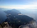
Aerial view of Texada Island
|
|

Texada Island (highlighted)
|
|
| Geography | |
|---|---|
| Location | British Columbia, Canada |
| Coordinates | 49°40′N 124°25′W / 49.667°N 124.417°W |
| Archipelago | Northern Gulf Islands |
| Area | 300.45 km2 (116.00 sq mi) |
| Length | 50 km (31 mi) |
| Width | 10 km (6 mi) |
| Highest elevation | 852 m (2,795 ft) |
| Highest point | Mount Shepherd |
Texada Island is a big island in British Columbia, Canada. It is located in the Strait of Georgia. With an area of about 300 square kilometers, it is the largest of the Gulf Islands. It is also the third largest island in the Strait of Georgia.
Long ago, many people lived here because of mining and logging. But now, those industries are much smaller. Fewer people live on the island since the 1950s. Today, Texada Island is a quiet place for vacations, camping, and enjoying warm waters and beautiful beaches.
Contents
- Island History: How Texada Got Its Name
- Texada Island's Geography and Location
- Plants and Animals: Texada's Natural World
- Parks and Tourism: Exploring Texada Island
- Communities and Services on Texada Island
- Getting Around: Transportation on Texada Island
- Island Industry: What Texada Produces
- Notable People from Texada Island
- Images for kids
- See also
Island History: How Texada Got Its Name
Texada Island was named by a Spanish explorer named José María Narváez. He named it after Felix de Tejada, a Spanish naval officer. This happened during an expedition in 1791.
Narváez first called a different island Isla de Texada. He called Texada Island Islas de San Felix. But later maps, made in 1791, moved the name "Texada" to the island we know today. When Canada became a country, the north end of Texada Island became a fishing village.
Mining and Early Life on Texada Island
Around 1898, copper was found in a place called Van Anda. Olive and Harry Treat discovered it. This led to the Cornell Mine, which had lots of copper and gold. A factory, a special railway, and a town were built. The town was named after Carrie Van Anda, whose husband was a rich American mining investor.
Even famous people like J. D. Rockefeller invested in the iron mines here. But he quickly sold his share. Other Canadian investors also put money into the Van Anda mines. At this time, farms, fruit orchards, logging, and sawmills also started on Texada Island.
By the early 1900s, the copper mining was very busy. But the mines only produced copper for a few years. Van Anda even had an opera house and a Chinatown. Sadly, a series of fires destroyed the Van Anda townsite. The last big fire was in 1917.
_capsized_at_Van_Anda,_BC_22_Jan_1913.jpg)
Ferries helped connect the island to cities like Vancouver and Nanaimo. The first ferry after the old steamships was called the Atrevida. A steamship called the Cheslakee flipped over near Van Anda on January 22, 1913. Seven people lost their lives.
Texada Island's Geography and Location
Texada Island is the largest of the Northern Gulf Islands. It is about 50 kilometers long and 10 kilometers wide. The island stretches from northwest to southeast.
Its northern tip is about 8 kilometers southwest of Powell River. It is also west of the Sechelt Peninsula. Texada is separated from the mainland by Malaspina Strait. It is separated from Lasqueti Island by Sabine Channel.
Surrounding Islands and Natural Features
Other islands nearby include Lasqueti, Jedediah, Ahgykson, Nelson, Hernando, and Savary Island. Many smaller islands and rocks are also found around Texada's shores.
The middle of the island is covered in forests. It also has several mountains. Many lakes of different sizes are on the island, with Priest Lake being the biggest.
The highest point on Texada Island is Mount Shepherd. It is near the southeastern part of the island. Mount Shepherd rises 852 meters above sea level.
Plants and Animals: Texada's Natural World
Texada Island is home to many different plants and animals. You can see them in the island's forests, waters, and skies.
Forests and Plant Life on Texada
Most of the plant species found on Texada Island are native to the coast of British Columbia. However, its forests are special. They have a lot of the inland type of lodgepole pine. These trees can be very large, with trunks over half a meter wide and trees over 60 meters tall.
Douglas fir and red alder are also common trees in the island's forests. Other trees like red cedar, Western white pine, Sitka spruce, Western hemlock, grand fir, and bigleaf maple are also present. Arbutus trees are common near the ocean but not in the island's center. The ground is covered by hundreds of shrub species. Sword Fern and Deer Fern are the most common.
Animals and Wildlife on Texada
The main large animal on the island is a small type of black-tailed Sitka deer. Unlike nearby islands and the mainland, Texada does not have large predators. There are no wolves, cougars, or bears here. Because of this, there are many deer on the island. You often see them along the roads. Having many deer also makes Texada a popular place for hunting in the fall.
Raccoons and rats have been brought to the island by accident. Garter snakes are common everywhere. Freshwater turtles can be found in small numbers in some lakes. Large birds like bald eagles, turkey vultures, ravens, and different types of hawks are common.
The Strait of Georgia around the island is a good place for fishing. You can catch all five types of Oncorhynchus (Pacific salmon), Lingcod, Rock cod, and coastal cutthroat trout. The lakes on the island also have several types of trout. There is even a special type of stickleback fish found only on Texada Island. The island's larger streams have small salmon runs.
Different types of seal have colonies on the shores of Texada Island. Sea otters are rare but sometimes seen. Orcas often eat seals and are the only large marine mammals seen very close to the island's shore. Other whales and dolphins travel through the strait but are rarely seen near land.
Parks and Tourism: Exploring Texada Island
Texada Island is a somewhat popular place for tourists. Most visitors come during the summer and fall. It is known for fishing, hunting, birdwatching, camping by the water, and kayaking. It also has great places for hiking and swimming. The water around the island can get as warm as 20 degrees Celsius in the summer. This makes it popular for water sports.
Camping and Parks on Texada
Several regional parks and forestry sites offer camping. Some are more remote than others. Shelter Point Regional Park is south of Gillies Bay. It is a popular and pretty camping spot with a boat launch. Shingle Beach is a more remote campground. It is also very scenic and a popular swimming spot.
Bobs Lake and Anderson Bay are very remote camping locations. They are far up logging roads. Getting to Anderson Bay requires a long drive on rough 4x4 roads.
Two provincial parks are on the southern tip of the island. These are Anderson Bay Provincial Park and South Texada Island Provincial Park. Anderson Bay can be reached by a long dirt track. This track starts at the end of the gravel road at Bob's Lake. You need a 4x4 vehicle because the road is very rough. Driving the last 15 kilometers can take an hour and a half. South Texada Park can only be reached by boat or a very long hike through the wilderness.
Communities and Services on Texada Island
The three main communities on Texada Island are Gillies Bay, Blubber Bay, and Van Anda. All of them are on the northern half of the island. Many homes on the island are vacation properties. This means they are only lived in for part of the year. The water for Gillies Bay comes from Cranby Lake.
A small community called Anderson Bay used to be on the south tip of the island. But the last person living there moved away in the 2000s. Now, the area is overgrown. This means the southern half of the island is almost empty. There is only one rough dirt track connecting it to the northern half. The permanent population is estimated to be around 1200 people.
Texada Island has two stores, a library, a credit union, and a gas station. It also has an elementary school, a hotel, and bed and breakfasts. There is a cemetery, two museums, two fire halls, and two thrift stores. The island also has an RCMP (police) station, an ambulance station, and two post offices. Besides the main stores, some farms sell fresh produce to tourists. There is also a farmers' market every summer.
Getting Around: Transportation on Texada Island
You can get to Texada Island from Powell River by ferry. BC Ferries operates 10 daily trips on the Island Discovery ferry. The Texada Island Ferry Terminal is in Blubber Bay.
Texada Island also has an airport called Texada/Gillies Bay Airport. It is near Gillies Bay. It has a 3,000-foot paved runway. This runway is used for private planes and chartered flights. An airport with a dirt runway used to be at Anderson Bay. But it has been overgrown for a long time.
The island has two main roads: Gillies Bay Road and Blubber Bay Road. Both are paved and have two lanes. Smaller paved roads connect to quarries, the airport, and Shelter Point Park. They also serve residents in the communities. There is also a "high road" from Van Anda that goes to the other half of the island. The more remote areas of the island are reached by gravel or dirt roads. Getting to the southern half of the island is becoming harder. The single dirt road there has gotten very rough over the years.
Island Industry: What Texada Produces
Texada Island was once a big center for mining and logging. But these industries have shrunk a lot. This caused the island's population to go down. Now, only a few quarries and some small logging operations are still active. These provide the main jobs on the island.
The island used to produce 5 million tons of limestone each year. However, recent economic changes have lowered the demand for it.
A large BC Hydro power line was built across the middle of the island in 1982. It links two underwater power lines that send electricity to Vancouver Island. A FortisBC natural gas pipeline was built in 1989. It runs from south to north. It then splits to provide gas to Powell River and Vancouver Island.
Notable People from Texada Island
- Jennifer Tilly, a Canadian-American actress and professional poker player.
- Meg Tilly, a Canadian-American actress.
- Frank Giustra, a Canadian businessman and philanthropist.
Images for kids
-
Texada Island

See also
 In Spanish: Isla Texada para niños
