
British Columbia Coast facts for kids
Quick facts for kids
British Columbia Coast
French: Côte de la Colombie-Britannique
|
|
|---|---|
    From top, left to right: Vancouver, Pacific Rim National Park Reserve, Lax Kw'alaams backdropped by the Kitimat Ranges, Qualicum Beach and the Strait of Georgia
|
|
| Nickname(s):
"The Coast"
|
|
| Country | |
| Province | |
| Principal cities | |
| Area | |
| • 15 Districts | 244,778 km2 (94,509 sq mi) |
| Highest elevation | 4,019 m (13,186 ft) |
| Lowest elevation | 0 m (0 ft) |
| Population
(2016)
|
3,686,900 |
| • Density | 80.24/km2 (207.8/sq mi) |
| Time zone | UTC−08:00 (PST) |
| • Summer (DST) | UTC−07:00 (PDT) |
| Postal code prefixes |
V
|
| Area codes | 236, 250, 604, 672, 778 |
The British Columbia Coast, also known as the BC Coast or simply the Coast, is a special part of the British Columbia province in Canada. It's basically the entire western coastline of Canada, stretching along the Pacific Ocean. When people talk about the "West Coast of Canada," they are usually talking about this region.
This area is generally made up of 15 different regional districts that touch either the Pacific Ocean or the Salish Sea. These districts include the Lower Mainland, which is a big part of the BC Coast. Sometimes, the exact borders can change, but this is the most common way to describe it.
Contents
What are the BC Coast Boundaries?
The name "British Columbia Coast" has been used for a long time, ever since people from other countries started settling in British Columbia. However, it has never been officially defined by law. Historically, it describes the part of the province that lies west of the Coast Mountains and North Cascades. This means it usually includes the 15 regional districts that are in this area.
Major Areas of the BC Coast
Locals often divide the British Columbia Coast into seven main areas:
- Vancouver Island: This includes Vancouver Island itself, the Gulf Islands, and sometimes Quadra Island.
- Lower Mainland: This large area includes Greater Vancouver, the Fraser Valley, and sometimes the Sea-to-Sky Corridor.
- Sunshine Coast: This part covers the islands and mainland coast between Howe Sound and Desolation Sound.
- South Coast: This combines the Lower Mainland and Sunshine Coast, but does not include Vancouver Island. It is strongly connected to the Salish Sea.
- Central Coast: This area includes islands and mainland coast from Desolation Sound up to Cape Caution. It's not very populated and includes the Strathcona and Mount Waddington districts. Sometimes, it extends further north to include the Central Coast Regional District.
- North Coast: This region stretches from Cape Caution to Portland Canal. It includes the Central Coast, Kitimat-Stikine, and North Coast districts. This area is famous for the Great Bear Rainforest.
- Haida Gwaii: This is a group of islands located about 90 km (56 mi) west of the mainland North Coast.
History of the BC Coast
Scientists have found that during the Ice Age, the coastline of British Columbia was about 100 meters (328 feet) lower than it is today. This meant that areas like Queen Charlotte Sound, which is between Haida Gwaii and Vancouver Island, were actually flat coastal plains.
Underwater archaeology has found signs of human settlements from the Ice Age at this 100-meter depth. This discovery suggests that this area might have been a major route for people migrating from (and maybe to) Asia.
The many inlets and mild climate of the BC Coast are similar to other places in the world, like the Aegean Sea or the coasts of Scandinavia. These areas also saw a lot of human settlement and cultural growth. The rich natural environment, full of seafood, wild game, and plants, along with easy travel by water, helped create advanced civilizations here. Some people compare the art and social structures of the Pacific Northwest Indigenous Peoples to those of ancient Greece or Scandinavia.
Geography of the BC Coast
The British Columbia Coast stretches from the southern tip of Vancouver Island all the way to Stewart in the north. This is about 954 km (593 mi) in a straight line. But because the coastline has so many deep inlets and over 40,000 islands, its total length is more than 25,725 km (16,000 mi). That's about 10% of Canada's entire coastline! This unique coastal shape is also seen in nearby Alaska and Washington.
The main landforms here are the Insular Mountains on Vancouver Island and Haida Gwaii, and the Coast Mountains that run along the entire coast. These mountains are so close to the ocean that they create deep, narrow inlets called fjords, which are similar to those in Norway. Some important fjords include Burrard Inlet, Howe Sound, Jervis Inlet, and Douglas Channel.
Climate of the BC Coast
The BC Coast mostly has a mild oceanic climate. This means it has warm summers, cool winters, and a lot of rain, especially in winter. These areas have the mildest winters in all of Canada, with temperatures rarely dropping far below freezing.
The very southern part of the coast, around the Salish Sea, has a warm-summer Mediterranean climate. This means it has warm, dry summers and cool, wet winters. As you go further north or inland, the climate gradually changes back to the oceanic type. Higher up in the mountains, it gets colder, with a subpolar oceanic climate or even a subarctic climate at the highest points.
Ecology of the BC Coast

The British Columbia Coast is covered mostly by temperate rainforest. Different groups use different ways to classify the natural areas here. For example, the World Wide Fund for Nature (WWF) divides the BC Coast into five distinct ecoregions, such as the British Columbia mainland coastal forests.
Environment and Climate Change Canada (ECCC) uses its own system, dividing the BC Coast into four ecozones, including the Pacific Coastal Mountains. The British Columbia Ministry of Forests also has its own system, classifying the BC Coast into two main biogeoclimatic zones: Coastal Western Hemlock and Coastal Douglas-fir.
People and Regional Districts
The British Columbia Coast is divided into 15 regional districts. These districts help manage local services and communities. Here's a look at them:
| Name | Population (2016) |
Area (km2) |
Density (/km2) |
Head office location |
|---|---|---|---|---|
| Alberni-Clayoquot | 30,981 | 6,588 | 4.7 | Port Alberni |
| Capital | 383,360 | 2,340 | 163.8 | Victoria |
| Central Coast | 3,319 | 24,492 | 0.14 | Bella Coola |
| Comox Valley | 66,527 | 1,701 | 39.1 | Courtenay |
| Cowichan Valley | 83,739 | 3,475 | 24.1 | Duncan |
| Fraser Valley | 295,934 | 13,335 | 22.2 | Chilliwack |
| Kitimat-Stikine | 37,367 | 104,461 | 0.36 | Terrace |
| Metro Vancouver | 2,463,431 | 2,883 | 854.5 | Burnaby |
| Mount Waddington | 11,035 | 20,244 | 0.55 | Port McNeill |
| Nanaimo | 155,698 | 2,038 | 76.4 | Nanaimo |
| North Coast | 18,133 | 19,781 | 0.92 | Prince Rupert |
| qathet | 20,070 | 5,075 | 4.0 | Powell River |
| Squamish-Lillooet | 42,665 | 16,310 | 2.6 | Pemberton |
| Strathcona | 44,671 | 18,278 | 2.4 | Campbell River |
| Sunshine Coast | 29,970 | 3,777 | 7.9 | Sechelt |
Economy of the BC Coast
The economy of the British Columbia Coast has always been closely tied to its natural resources and unique geography.
Fishing Industry

The fishing industry on the Pacific Northwest Coast is very famous, especially for its many salmon runs. For a long time, the cultures in this region relied heavily on salmon. However, salmon numbers have dropped a lot since commercial fishing and canning began.
Other important commercial fisheries include halibut, herring (and herring roe), sea urchin, hake, haddock, cod, crab, and various shellfish.
Transportation in the BC Coast
Getting around the BC Coast involves a mix of roads, ferries, and ports.
Highways for Travel
The Coast Region of British Columbia is connected to the rest of the province by several highways.
- The busy Fraser Valley and Lower Mainland areas are linked by Highway 1 (Fraser Canyon Highway), Highway 5 (Coquihalla Freeway), Highway 3 (Crowsnest Highway), and Highway 99 (Sea to Sky Highway).
- The Lower Mainland also connects to the United States through four highway border crossings, with the Peace Arch on Interstate 5 being the largest. Many freeways connect communities within the Lower Mainland.
- On Vancouver Island, the main road is Highway 19, which, along with part of Highway 1, forms the Island Highway. This highway has sections of freeway, arterial road, and two-lane highway, mostly running along the east coast of Vancouver Island. You can reach the west coast of Vancouver Island by crossing mountain passes on Highway 4 to Tofino and Highway 23 to Gold River.
- The Sunshine Coast is on the mainland but can only be reached by ferries. It has one main route, Highway 101, which is a narrow, winding two-lane road split by a ferry crossing.
- Because of the challenging mountains and coastline, there isn't one continuous north-south highway connecting all the coastal communities between Port Hardy and Kitimat. Instead, people use coastal ferry lines operated by BC Ferries. Some towns like Bella Coola, Terrace, Prince Rupert, and Kitimat can be reached by highways from the BC interior.
- Haida Gwaii has an extension of Highway 16, which is one of its few paved roads.
Maritime Routes and Ferries
.jpg)
The protected waterways along the British Columbia Coast are part of the Inside Passage. This is a special route that ships use to avoid the rough open waters of the North Pacific. Because of this, many cruise ships, cargo ships, ferries, and other boats use this route.
BC Ferries, a company owned by the public, runs daily scheduled trips between major towns along the BC Coast. Many smaller ferries also operate on shorter routes within and between these regions. The Alaska Marine Highway also offers ferry service through the British Columbia Coast on its Bellingham-Ketchikan route.
Important Ports
The Port of Vancouver is the biggest commercial shipping port in Canada. It's also the largest on the entire Pacific coast of North America when measured by the amount of cargo it handles (76.5 million metric tons). It's also the fifth largest commercial shipping port in North America overall.
The Port of Prince Rupert has the deepest ice-free natural harbour in North America, and the third deepest natural harbour in the world. Located at 54° North, it's the most northwestern port in North America that is connected to the continent's railway system. This port is often the first stop for cargo ships coming from eastern Asia and the last stop for those going to Asia, because it's the closest North American port to key Asian destinations.
Images for kids
-
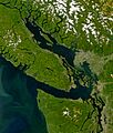
The Strait of Georgia at centre, the Strait of Juan de Fuca below, Puget Sound at the lower right, Johnstone Strait at the extreme upper left. Sediment from the Fraser River clearly visible.
-
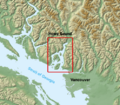
Location of Howe Sound in British Columbia.
.jpg)


See also
 In Spanish: Costa de la Columbia Británica para niños
