Cowichan Valley Regional District facts for kids
Quick facts for kids
Cowichan Valley
|
||
|---|---|---|
|
Regional district
|
||
| Cowichan Valley Regional District | ||

|
||
|
||

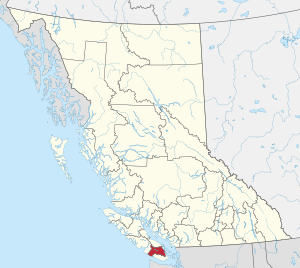
Location in British Columbia
|
||
| Country | Canada | |
| Province | British Columbia | |
| Administrative office location | Duncan | |
| Government | ||
| • Type | Regional district | |
| • Body | Board of Directors | |
| Area | ||
| • Land | 3,474.52 km2 (1,341.52 sq mi) | |
| Population
(2016)
|
||
| • Total | 83,739 | |
| • Density | 24.1/km2 (62/sq mi) | |
| Website | cvrd.bc.ca | |
The Cowichan Valley Regional District is a special area in British Columbia, Canada. It's located on the southern part of Vancouver Island. This region is bordered by other districts like Nanaimo to the north and the Capital Regional District to the south. In 2016, about 83,739 people lived here. The main office for the district is in Duncan.
Contents
Exploring the Cowichan Valley Region
The Cowichan Valley Regional District covers a large area. It stretches from the Stuart Channel and Saanich Inlet on the east coast of Vancouver Island. It also includes part of the famous West Coast Trail.
Lakes and Islands
Right in the middle of the district, you'll find Cowichan Lake and the beautiful Cowichan Valley. The district also includes several Gulf Islands. These islands are Thetis, Kuper, and Valdes. The total land area of the district is about 3,473 square kilometers. That's a lot of space to explore!
Communities in the Valley
The Cowichan Valley Regional District is home to many different communities. Some are towns and cities, while others are Indigenous Reserves or smaller electoral areas.
Cities and Towns
These are the main towns and cities in the district:
- City of Duncan
- Town of Ladysmith
- Town of Lake Cowichan
- District Municipality of North Cowichan
Indigenous Reserves
Many Indigenous communities are also part of the Cowichan Valley. These are special areas set aside for First Nations people. Here are some of them:
- Chemainus 13
- Claoose 4
- Cowichan 1
- Cowichan 9
- Cowichan Lake
- Est-Patrolas 4
- Halalt 2
- Kil-pah-las 3
- Kuper Island 7
- Lyacksun 3
- Malachan 11
- Malahat 11
- Oyster Bay 12
- Portier Pass 5
- Shingle Point 4
- Squaw-hay-one 11
- Theik 2
- Tsussie 6
- Wyah 3
Electoral Areas: Local Neighborhoods
The district is also divided into smaller "electoral areas." These are like different neighborhoods or rural communities. Each area has its own representatives on the district's board.
Area A: Malahat and Mill Bay
- Malahat
- Mill Bay
Area B: Shawnigan Lake
- Shawnigan Lake
Area C: Cobble Hill and More
- Arbutus Ridge
- Cobble Hill
- Cherry Point
Area D: Cowichan Bay
- Cowichan Bay
Area E: Cowichan Station and Beyond
- Cowichan Station
- Eagle Heights
- Glenora
- Koksilah
- Sahtlam
Area F: Cowichan Lake South
- Honeymoon Bay
- Mesachie Lake
- Skutz Falls
Area G: Saltair and Gulf Islands
- Saltair
Area H: North Oyster and Diamond
- Diamond
- North Oyster
- Yellow Point
Area I: Youbou and Meade Creek
- Meade Creek
- Youbou
 | Ernest Everett Just |
 | Mary Jackson |
 | Emmett Chappelle |
 | Marie Maynard Daly |

