
Penelakut Island facts for kids
Quick facts for kids
Penelakut Island
formetjgw8 i7
|
|
|---|---|
| Country | Canada |
| Population | |
| • Total | 302 |
| Time zone | UTC−8 (PST) |
| • Summer (DST) | UTC−7 (PDT) |
Penelakut Island is a beautiful island in British Columbia, Canada. It used to be called Kuper Island. In 2010, it was renamed to honor the Penelakut First Nation people who live there.
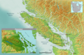
The island is part of the southern Gulf Islands. These islands are located between Vancouver Island and the mainland coast of British Columbia. About 300 members of the Penelakut Band live on the island. Penelakut Island covers an area of about 8.66 square kilometres (3.34 sq mi).
You can get to Penelakut Island by ferry. There are regular car and passenger ferries from Chemainus on Vancouver Island. On the west side of the island, you'll find Telegraph Harbour.
Penelakut Island has a special climate. It has mild winters and warm, dry summers. This is like a Mediterranean climate. This weather helps unique plants and animals grow there. The island is in the rain shadow of Vancouver Island. This means it gets less rain, about 850 millimetres (33 in) each year.
On the island, there is a Roman Catholic Church and a longhouse. A longhouse is a traditional building used by many First Nations. There are no regular stores or businesses on the island. From 1890 to 1978, a Residential School was run by the Catholic Church on the island. Today, the Penelakut people run their own school. Most land on the island is part of an Indian reserve. This means you cannot buy property there.
Contents
History of Penelakut Island
Early Explorations and Naming
In 1851, the British Royal Navy explored this area. They sailed into a group of five islands in the Strait of Georgia. The two largest islands were named Kuper and Thetis. These names honored Captain Augustus Leopold Kuper and his ship, HMS Thetis. Captain Kuper was a Royal Navy officer. His ship was a frigate that served in the Pacific from 1851 to 1853.
Important Events and Conflicts
In 1861, about 300 Bella Bella people were traveling north from Victoria. On their journey, they attacked the Penelakut Natives on Kuper Island. The Penelakut tribe had about 400 members. This event resulted in many Penelakut people losing their lives.
A Nanaimo chief named Winni-win-chin was visiting Kuper Island at the time. He escaped and went to Nanaimo. He told Mr. A.G. Horne about the attack. Mr. Horne was in charge of the Hudson's Bay Company Post. He sent people to Victoria to report what had happened.
Later, in April 1863, a British gunboat called HMS Forward approached the village on Kuper Island. The captain thought the village might be helping people from another tribe. These people were believed to be involved in recent conflicts in the Gulf Islands. The gunboat fired at the village. However, the island warriors fought back strongly. The gunboat had to leave after a battle.
After this event, the colonial government responded with a large military action. This took place along the east coast of Vancouver Island. It also spread through the waters and islands of Active Pass, Trincomali Channel, and Stuart Channel. After gaining control of the area, the government established its rule. This eventually led to the formation of the Province of British Columbia.
Gallery
-
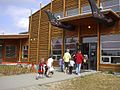
Kuper Island School
-
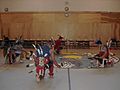
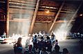
Ceremonial Dance, Kuper School Gymnasium
-
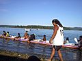
Ceremonial Canoe Races, 2006, Penelakut
-
Penelakut Longhouse
-
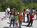
New Friends-Galiano Students visit Penelakut Band School, Penelakut


Images for kids
-
Map of traditional Penelakut tribal territory

See also
 In Spanish: Isla Kuper para niños
