Trincomali Channel facts for kids
Quick facts for kids Trincomali Channel |
|
|---|---|

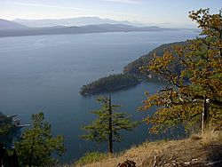
Looking up Trincomali Channel from Sutil Mountain on Galiano Island
|
|

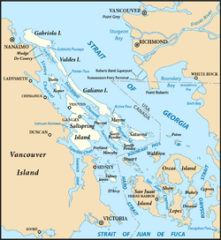
Map of the Southern Gulf Islands showing Trincomali Channel (centre left)
|
|
| Location | Southern Gulf Islands, British Columbia, Canada |
| Coordinates | 48°58′00″N 123°35′00″W / 48.96667°N 123.58333°W |
| Type | Channel |
| Part of | Salish Sea |
| Max. length | 34 kilometres (21 mi) |
| Max. width | 5 kilometres (3.1 mi) |
Trincomali Channel is a long, narrow waterway located in the beautiful Gulf Islands of British Columbia, Canada. It is like a natural highway for boats, connecting different islands and leading out to the larger Salish Sea.
Etymology
The name of Trincomali Channel comes from a ship called HMS Trincomalee. This ship was part of the Royal Navy. It was stationed at Esquimalt in British Columbia from 1852 to 1856. So, the channel is named after this important naval vessel.
Geography
Trincomali Channel is surrounded by several islands. To the north, you will find Pylades Island. To the west are Thetis, Penelakut, and Salt Spring Island. On the east side, there are Valdes and Galiano Island. Prevost Island is located to the south.
Two important passages connect the channel to the Strait of Georgia. Active Pass is at the south end of Galiano Island. Porlier Pass is at the north end of Galiano Island. These passes help boats travel between the channel and the wider strait.
The channel itself also contains several smaller islands. The largest of these is Parker Island, which is located southwest of Galiano Island.
 | Janet Taylor Pickett |
 | Synthia Saint James |
 | Howardena Pindell |
 | Faith Ringgold |


