
Galiano Island facts for kids
Quick facts for kids
Galiano Island
Swiikw
Hul'q'umín'um' |
|
|---|---|
|
Island
|
|
.png)
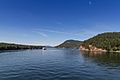
Galiano Island and the Salish Sea
|
|

Map of Galiano and surrounding islands
|
|
| Country | Canada |
| Province | British Columbia |
| Region | Southern Gulf Islands |
| Regional District | Capital Regional District |
| Islands Trust | Galiano Island Local Trust Area |
| Area | |
| • Land | 60.15 km2 (23.22 sq mi) |
| Population | |
| • Total | 1,044 |
| • Density | 17.4/km2 (45/sq mi) |
| Time zone | UTC−08:00 (PST) |
| • Summer (DST) | UTC−07:00 (PDT) |
| Postal Code |
V0N 1P0
|
| Area code(s) | 250 |
Galiano Island (called Swiikw in the Hul'qumi'num' language) is one of the Southern Gulf Islands. These islands are located between Vancouver Island and the Lower Mainland area of British Columbia, Canada. Galiano is on the west side of the Strait of Georgia. It is next to Mayne Island to the southeast, Salt Spring Island to the west, and Valdes Island to the northwest.
Galiano Island is part of the Capital Regional District Electoral Area G. In 2016, about 1,044 people lived there all year round. The island is named after a Spanish explorer, Dionisio Alcalá Galiano. He explored this area in 1792. Galiano Island is even twinned with his hometown, Cabra, in Spain.
Contents
History of Galiano Island
_-_An%C3%B3nimo.jpg)
Before Europeans arrived, Indigenous groups lived on Galiano Island for a very long time. The Penelakut First Nation and other Coast Salish peoples used the island as a summer spot for fishing. Old shell piles, called midden pits, at Montague Harbour show that people lived here for at least 3,000 years.
In the late 1770s, a serious smallpox disease spread through the Coast Salish region. This happened even before many Europeans came. It sadly killed about 30% of the people living there. More outbreaks over the next century caused the First Nations population to shrink even more.
European Arrival and Naming
In 1858, gold was found on the British Columbia mainland. This news reached San Francisco, and Victoria became a busy port for miners heading to the Fraser Canyon gold fields. Because more white settlers were interested in the area, the Royal Navy sent Captain George Henry Richards to map the area around Galiano Island in 1859. He decided to name the island after the Spanish explorer who had visited 67 years earlier.
Early Industries and Settlement
In the early days of European settlement, the main jobs on the island were fishing and cutting down trees (logging). The soil on Galiano was not very good for farming. This meant that large farms, like those on nearby Salt Spring Island, did not develop here. Early settlers started a small farming community near "Plumper Pass," which is now called Active Pass. Other settlers, like Scotty Georgeson, also owned land and had families on Galiano during this time.
Japanese Immigrants and Community Growth
Starting in the 1870s, some Asian immigrants, especially from Japan, came to Galiano. They settled here because of the many fish and trees. These Japanese immigrants, mostly from Wakayama Prefecture, brought ways of making charcoal. You can still find signs of their charcoal production on the island today. Many of these Japanese settlers ran fish salteries (places that salted fish) on the north end of the island. They continued until World War II started with Japan, when they were forced to leave.
After British Columbia joined Canada in 1871 and the Canadian Pacific Railway was finished in 1885, the nearby Lower Mainland grew very quickly. By 1928, Galiano's small community had grown enough to build the Galiano Community Hall, which is still used today.
Environmental Concerns and Modern Galiano
In the 1960s, a company called MacMillan Bloedel was given rights to cut down many trees on the island. Many people who cared about the environment did not like this widespread logging. This led to disagreements, including a court case in 1995. Caring for the environment and the "counter-culture" ideas of the 1960s still strongly shape the island's way of life today. In 2006, the area that Galiano is part of, Saanich—Gulf Islands, elected Canada's first Green Party member of parliament, Elizabeth May.
Today, the logging industry has mostly stopped on the island. Instead, jobs like tourism and a local art scene have become more important.
Geography of Galiano Island
.jpg)

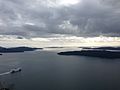
Galiano is a long, narrow island located on the western edge of the Salish Sea. It is about 27.5 kilometers (17 miles) long and only 1.6 kilometers (1 mile) wide at its narrowest part.
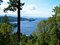
Mount Galiano is the highest point on the island, rising 314 meters (1,030 feet) above the sea. From the top, hikers can see amazing views of the Gulf Islands, the San Juan Islands in the United States, and mountains far away on the mainland. West of Mount Galiano is Sutil Mountain, which is 290 meters (951 feet) high. It is a special Ecological Reserve and is named after Captain Galiano's ship.
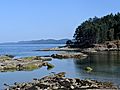
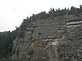
The western coast of the island, which faces Trincomali Channel, has cool and unique sandstone formations and caves.
Wildlife and Nature
Because of its mild weather, Galiano Island is home to many different animals and plants. It is on a major path for birds that are migrating, so hundreds of bird species can be seen here. These include bald eagles, herons, and cormorants. In the waters around the island, you can find orca whales, seals, otters, sea lions, and many other kinds of sea life. The island also has a large population of deer.
Many native trees grow well on the island. These include arbutus trees, western red cedar, and Coast Douglas-fir. While most of the island's trees have been cut down since Europeans settled, some limited old-growth forests (very old forests) still exist. For example, you can find them on the southern side of Bluffs Park.
Climate on Galiano Island
Galiano Island has a climate called a warm-summer Mediterranean climate. This means it has cool, wet winters and warm, dry summers. Like other Gulf Islands, Galiano's climate is mostly shaped by the "rain shadow" effect from the Olympic and Vancouver Island mountains. This effect means the mountains block much of the rain. The ocean also helps keep the temperatures mild.
From mid-June to early October, Galiano Island often has a "moisture deficit." This means it doesn't get enough rain because of the dry, sunny, and warm weather. This can sometimes lead to very dry conditions, especially in areas where trees were recently cut down. This can cause a high risk of forest fires in the summer.
| Climate data for Galiano Island | |||||||||||||
|---|---|---|---|---|---|---|---|---|---|---|---|---|---|
| Month | Jan | Feb | Mar | Apr | May | Jun | Jul | Aug | Sep | Oct | Nov | Dec | Year |
| Mean daily maximum °C (°F) | 6.3 (43.3) |
8.1 (46.6) |
10.1 (50.2) |
13.0 (55.4) |
16.4 (61.5) |
19.4 (66.9) |
21.9 (71.4) |
21.8 (71.2) |
18.8 (65.8) |
13.9 (57.0) |
9.5 (49.1) |
6.6 (43.9) |
13.8 (56.9) |
| Daily mean °C (°F) | 3.4 (38.1) |
4.6 (40.3) |
6.1 (43.0) |
8.5 (47.3) |
11.5 (52.7) |
14.5 (58.1) |
16.5 (61.7) |
16.4 (61.5) |
13.8 (56.8) |
9.8 (49.6) |
6.2 (43.2) |
3.7 (38.7) |
9.6 (49.3) |
| Mean daily minimum °C (°F) | 0.5 (32.9) |
1.1 (34.0) |
2.1 (35.8) |
4.1 (39.4) |
6.7 (44.1) |
9.6 (49.3) |
11.2 (52.2) |
11.1 (52.0) |
8.9 (48.0) |
5.8 (42.4) |
2.9 (37.2) |
0.9 (33.6) |
5.4 (41.7) |
| Average precipitation mm (inches) | 153 (6.0) |
112 (4.4) |
90 (3.5) |
59 (2.3) |
45 (1.8) |
36 (1.4) |
24 (0.9) |
29 (1.1) |
47 (1.9) |
98 (3.9) |
165 (6.5) |
162 (6.4) |
1,020 (40.1) |
| Source: Climate-Data | |||||||||||||
Getting to Galiano Island

You can reach Galiano Island by car or as a passenger using the BC Ferries service. The ferry terminal is at Sturdies Bay, located on Active Pass. Ferries run from Tsawwassen (near Vancouver) on the mainland and Swartz Bay (near Victoria) on Vancouver Island almost every day. There are also ferries that connect Galiano to other Gulf Islands, but these run less often.
If you have a boat, you can moor (park) it at several public docks. These include Sturdies Bay (which is close to the village), Montague Harbour, Whalers Bay, and Retreat Cove. Private places to moor boats are available at Montague Harbour Marina and the Galiano Oceanfront Inn. You can also find limited water taxi services from Sturdies Bay and Montague Harbour to nearby islands like Salt Spring.
You can also fly to Galiano Island by floatplane. There are daily flights from Downtown Vancouver and the Vancouver International Water Airport through Seair Seaplanes to Montague Harbour. Kenmore Air also offers daily floatplane service from Seattle, including from Seattle-Tacoma International Airport and Seattle Lake Union.
Once you are on the island, most areas can be reached by paved roads. However, some logging roads are still used in parts of the island that are not as busy.
Parks on Galiano Island
Galiano is home to many popular public parks like Montague Harbour and Dionisio. There are also privately owned parks such as Tapovan Peace Park.


- Montague Harbour Marine Provincial Park is one of the most popular parks in the Gulf Islands. It has a special "Shell Beach" on its west side. This beach is covered entirely with worn shells instead of sand. For thousands of years, this was a midden site used by the Coast Salish people. Montague Harbour is a favorite spot for people who enjoy boating. The harbor is often full of yachts and sailboats during the warmer months of June, July, and August. The park has mooring buoys, but they are limited and cannot be reserved. The harbor is also a safe place to anchor your boat. At the south end of the harbor, there is a marina with boat moorage, a gas dock, small stores, and a cafe (open only in summer). A public dock is also located near the marina.
- Dionisio Point Provincial Park is a wild, natural park at the north end of the island. You can only reach it by boat or by walking in. It has beautiful beaches that locals call Coon Bay. Here, you'll find unique sandstone formations, a sandy beach for swimming, tidal pools (small pools of water left by the tide), colorful wildflowers, and forests.
- Mount Galiano is the highest point on Galiano. It rises 314 meters (1,030 feet) above sea level. From the top, hikers get great views of the Gulf Islands, the U.S. San Juan Islands, and the distant mainland mountains.
- Collinson Point Provincial Park is the shoreline area of Mount Galiano. It is important for protecting the marine life in the waters near Active Pass.
- Bodega Ridge Provincial Park has a ridge that rises over 240 meters (787 feet) above sea level. From here, you can see many of the Gulf Islands' hundreds of islands and small islets, and even the mountains of the Olympic Peninsula. High cliffs in the park are home to birds of prey like peregrine falcons and bald eagles. You can also find trees like cedars and Douglas firs here.
- Matthews Point Park is a 25-hectare (62-acre) park managed by the Capital Regional District. It protects over a kilometer (0.6 miles) of waterfront along Active Pass, including 300 meters (984 feet) of wide sandy beach. The park was named after a pioneer family. There is also a hiking trail along the clifftops. It connects to Bluffs Park.
- The Trincomali Nature Sanctuary is an area with steep cliffs. The Islands Trust set it aside to protect birds like Double-crested cormorants and Peregrine Falcons, among other species.
Government on Galiano Island
Several government groups oversee Galiano Island. These include the Federal government, the Provincial government of British Columbia, and the Capital Regional District. There is also the Islands Trust, which has a special job to "preserve and protect" the island. This means they create rules about how land can be used and developed. For most of the 20th century, about half of Galiano's land was owned by a logging company called MacMillan Bloedel. Because of this, Galiano was not developed as much as some other nearby islands. When the company sold its land on Galiano, there was a lot of discussion about development. The Islands Trust then set rules for minimum lot sizes to limit how much new building could happen.
Local elections are held every three years to choose the island's two Trustees. These Trustees help make decisions for the island.
There is one Indian reserve on the island called Galiano Indian Reserve No. 9. It is located at the northern tip of the island and is managed by the Penelakut First Nation.
Tourism on Galiano Island
Because Galiano has not been overly developed, tourism on the island has remained small and respectful of the environment. There are two main hotels and several cabin resorts. Most places to stay are Bed and Breakfasts, the Montague Provincial Park Campsite, or holiday rentals.
Things to do on Galiano Island include hiking, boating, visiting art galleries, playing golf, and exploring the beaches. There are also often musical events. The Pilgrimme Restaurant is well-known for its food made from local ingredients and foraged items. It attracts visitors from all over who want to try high-quality Pacific Northwest food.
Infrastructure
The HVDC Vancouver Island powerline crosses Galiano Island. It is an overhead powerline that runs southwest and ends at a cable terminal on Parker Island.
Gallery
-
Montague Harbour
-
View from Mt. Galiano (late winter)
-
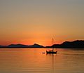
Montague Harbour sunset in summer
-
Dionsio Marine Provincial Park
-
Mt. Galiano seen through Active Pass
-
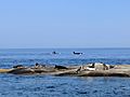
Orcas and Seals at Dionisio Provincial Park


.jpg)

Images for kids
-
Islands Trust Cormorant Sanctuary

See also
 In Spanish: Isla Galiano para niños
