Wakayama Prefecture facts for kids
Quick facts for kids Wakayama Prefecture |
|||||||||
|
|||||||||
 |
|||||||||
| Capital | Wakayama | ||||||||
| Region | Kansai | ||||||||
| Island | Honshū | ||||||||
| Governor | Yoshinobu Nisaka | ||||||||
| Area (rank) | 4,725.67 km² (30th) | ||||||||
| - % water | 0.04% | ||||||||
| Population (April 1, 2012) | |||||||||
| - Population | 989,983 (39th) | ||||||||
| - Density | 209.49 /km² | ||||||||
| Districts | 6 | ||||||||
| Municipalities | 30 | ||||||||
| ISO 3166-2 | JP-30 | ||||||||
| Website | www.wakayama.lg.jp/ english/ |
||||||||
| Prefectural Symbols | |||||||||
| - Flower | Ume blossom (Prunus mume) | ||||||||
| - Tree | Ubame oak (Quercus phillyraeoides) | ||||||||
| - Bird | Japanese white-eye (Zosterops japonica) | ||||||||
| - Fish | |||||||||
 Symbol of Wakayama Prefecture |
|||||||||
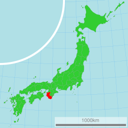
Wakayama Prefecture (和歌山県, Wakayama-ken) is a special area in Japan. It is called a prefecture. You can find it in the Kansai region on the island of Honshū. The main city, or capital, is Wakayama City.
Wakayama Prefecture is surrounded by other prefectures. These include Osaka Prefecture, Nara Prefecture, and Mie Prefecture. It also shares borders with Hyōgo Prefecture and Tokushima Prefecture.
Contents
History of Wakayama
Wakayama Prefecture has an interesting past. It was created during the Meiji period. This was a time of big changes in Japan. Before becoming Wakayama Prefecture, this area was the western part of a place called Kii Province.
Geography and Nature
Wakayama Prefecture has a beautiful coastline. Its southwestern side faces the Seto Inland Sea. The southeastern side looks out onto the big Pacific Ocean. The northern parts of the prefecture meet Osaka Prefecture, Nara Prefecture, and Mie Prefecture.
Cities in Wakayama
There are nine main cities in Wakayama Prefecture. Each city is an important center for people living there. The capital city is Wakayama.
|
|
|
Towns and Villages
Besides cities, Wakayama Prefecture also has many towns and villages. These smaller communities are grouped into districts.
|
|
|
National Parks
Wakayama Prefecture is home to beautiful nature. About 9% of its total land area is protected as National Parks. These parks help keep the natural environment safe and beautiful for everyone to enjoy.
Shrines and Temples
Wakayama has many important religious sites. Hinokuma-kunikakasu jinjū is a very special Shinto shrine. It is known as the chief shrine, or ichinomiya, in the prefecture. Shinto shrines are places of worship in the Shinto religion of Japan.
See also
 In Spanish: Prefectura de Wakayama para niños
 | Sharif Bey |
 | Hale Woodruff |
 | Richmond Barthé |
 | Purvis Young |


