
Salt Spring Island facts for kids
Quick facts for kids
Salt Spring Island
|
||
|---|---|---|

Ganges Harbour on Salt Spring island
|
||
|
||
| Nickname(s):
Salt Spring, SSI
|
||

Salt Spring Island
Location in British Columbia
|
||
| Country | Canada | |
| Province | British Columbia | |
| Regional district | Capital | |
| Area | ||
| • Land | 182.7 km2 (70.5 sq mi) | |
| Population
(2021)
|
||
| • Total | 11,635 | |
| • Density | 63.7/km2 (165/sq mi) | |
| Time zone | UTC−8 (PST) | |
| • Summer (DST) | UTC−7 (PDT) | |
| Forward sortation area |
V8K
|
|

Salt Spring Island, also called Saltspring Island, is a beautiful island in British Columbia, Canada. It's one of the many Gulf Islands located in the Strait of Georgia, which is between mainland British Columbia and Vancouver Island.
This island was first home to various Salishan Indigenous peoples. Later, in 1859, pioneers began to settle here. At that time, it was called Admiral Island. Salt Spring Island was the first of the Gulf Islands to be settled. It was also the first place in the Colony of Vancouver Island where people could start farms. Settlers could even claim land before buying it, which was a new idea back then. In 1910, the island was renamed to its current name, Salt Spring Island. It got this name because of the natural salt springs found in its northern part.
Today, Salt Spring Island is the biggest and most visited of the Southern Gulf Islands. It also has the most people living on it.
Contents
- A Look Back at Salt Spring Island's History
- What's in a Name? Salt Spring Island's Etymology
- Where is Salt Spring Island?
- Salt Spring Island's Climate
- Exploring Salt Spring Island: Hiking and Cycling
- Famous Faces: Notable Residents
- Learning on Salt Spring Island: Education
- Getting Around Salt Spring Island: Transportation
- Salt Spring Island Public Library
- Staying Connected: Communications
- Keeping Salt Spring Island Safe: Emergency Services
- Images for kids
- See also
A Look Back at Salt Spring Island's History
Salt Spring Island was originally known as ĆUÁN (čuʔén) by the Salishan peoples. They had many names for different places on the island. For example, Beaver Point was called ȾESNO¸EṈ¸ (t̕ᶿəsnáʔəŋ̕). Ganges Harbour was known as SYOW̱T (syaxʷt).
Early Settlers and Their Stories
The northern part of the island was mainly settled by African Americans who came from California. The southern part was settled by Native Hawaiians, who were known as 'Kanaka'. Other settlers came from places like Portugal and the British Isles, including England, Ireland, and Scotland.
Many Black settlers left California in 1858. This was because California had passed laws that treated African Americans unfairly. Before they moved, a man named Mifflin Wistar Gibbs and two others visited Governor James Douglas. They wanted to know how people of African descent would be treated in the new colony. Governor Douglas, who was from Guyana and had a mixed background, promised them fair treatment. He also told them that slavery had been ended in the colony more than 20 years earlier.
In the 1800s, communities like Vesuvius and Ganges had many African-American residents. However, between 1867 and 1868, some Black men were sadly killed in Vesuvius Bay. These events made the island a difficult place for Black residents, and many young people moved away to bigger cities like Victoria and Vancouver.
Salt Spring Island was the first of the Gulf Islands to be settled by non-First Nations people. It was also the first place in the Colony of Vancouver Island where farms were started that were not owned by big companies like the Hudson's Bay Company.

Salt Spring Island was special because it was the first place in British Columbia where settlers could get land through "pre-emption." This meant they could live on and improve the land first. After showing they had worked on it, they could buy it for one dollar per acre. This way of buying land helped make sure the land was used for farming. It also meant that most of the early settlers were families.
Many early families on the island grew food for themselves, which is called subsistence farming. They also did other jobs like fishing and logging to earn money. Some families later left their land because there weren't enough services on the island, or because of harsh weather, like a very cold winter in 1862 that killed their farm animals.
A Time of Change: World War II and Beyond
During World War II, about 77 Japanese Canadian families living on Salt Spring Island had to leave their homes. This was because the government made them move away from the coast. Their properties were managed by a "Custodian." Even though the families were told their homes would be safe, many properties were sold without their permission. Only one Japanese Canadian family, the Murakamis, was able to buy property and return to the island after the war.
In the 1960s, Salt Spring Island became a safe place for some people from the United States. These were "draft evaders" who did not want to join the military during the Vietnam War.

What's in a Name? Salt Spring Island's Etymology
The island was called "Chuan" or "Chouan" Island in 1854. But it was also known as "Salt Spring" as early as 1855. This name came from the natural salt springs found on the island.
In 1859, a surveyor named Captain Richards officially named it "Admiralty Island." He did this to honor Rear-Admiral Robert Lambert Baynes and his ship, HMS Ganges. Even with the official name, people still commonly called it Salt Spring.
The island was officially renamed Saltspring on March 1, 1910. However, some unofficial sources say it was 1905 or 1906. Today, locals often use both "Salt Spring" (two words) and "Saltspring" (one word). The official chamber of commerce uses the two-word name.
Where is Salt Spring Island?
Salt Spring Island is located between mainland British Columbia and Vancouver Island. It's the most visited and most populated of the Gulf Islands. In 2016, about 10,557 people lived there. The biggest village on the island is Ganges. The island is well-known for its many artists.
Did you know? Besides Canadian dollars, some businesses on Salt Spring Island also accept their own local money, called the Salt Spring dollar!
The island is part of the Southern Gulf Islands. These islands are all part of the Capital Regional District, which also includes the cities around Victoria. The highest point on Salt Spring Island is Bruce Peak, which is over 700 m (2,300 ft) (about 2,300 feet) above sea level.

Salt Spring Island's Climate
Salt Spring Island has a mild climate. This means it has warm, dry summers and cool winters. It's similar to a mediterranean climate.
| Climate data for Saltspring Island (St. Mary's Lake) 1981–2010 normals, extremes 1975-present | |||||||||||||
|---|---|---|---|---|---|---|---|---|---|---|---|---|---|
| Month | Jan | Feb | Mar | Apr | May | Jun | Jul | Aug | Sep | Oct | Nov | Dec | Year |
| Record high °C (°F) | 14.0 (57.2) |
15.0 (59.0) |
19.5 (67.1) |
25.5 (77.9) |
29.5 (85.1) |
34.0 (93.2) |
33.5 (92.3) |
41.0 (105.8) |
31.5 (88.7) |
25.5 (77.9) |
16.0 (60.8) |
17.0 (62.6) |
41.0 (105.8) |
| Mean daily maximum °C (°F) | 6.5 (43.7) |
7.8 (46.0) |
10.4 (50.7) |
13.5 (56.3) |
17.1 (62.8) |
20.1 (68.2) |
22.7 (72.9) |
22.8 (73.0) |
19.5 (67.1) |
13.8 (56.8) |
8.8 (47.8) |
6.1 (43.0) |
14.1 (57.4) |
| Daily mean °C (°F) | 4.3 (39.7) |
5.0 (41.0) |
7.0 (44.6) |
9.6 (49.3) |
12.9 (55.2) |
15.8 (60.4) |
18.1 (64.6) |
18.4 (65.1) |
15.4 (59.7) |
10.8 (51.4) |
6.6 (43.9) |
4.1 (39.4) |
10.7 (51.3) |
| Mean daily minimum °C (°F) | 2.0 (35.6) |
2.2 (36.0) |
3.5 (38.3) |
5.6 (42.1) |
8.7 (47.7) |
11.5 (52.7) |
13.5 (56.3) |
13.9 (57.0) |
11.3 (52.3) |
7.7 (45.9) |
4.3 (39.7) |
2.1 (35.8) |
7.2 (45.0) |
| Record low °C (°F) | −10.0 (14.0) |
−10.5 (13.1) |
−6.0 (21.2) |
−1.0 (30.2) |
2.0 (35.6) |
4.4 (39.9) |
5.0 (41.0) |
8.0 (46.4) |
5.0 (41.0) |
−3.0 (26.6) |
−10.0 (14.0) |
−11.0 (12.2) |
−11.0 (12.2) |
| Average precipitation mm (inches) | 162.1 (6.38) |
98.5 (3.88) |
88.6 (3.49) |
56.8 (2.24) |
43.0 (1.69) |
37.4 (1.47) |
23.2 (0.91) |
28.0 (1.10) |
33.1 (1.30) |
94.0 (3.70) |
167.9 (6.61) |
154.3 (6.07) |
987.0 (38.86) |
| Average rainfall mm (inches) | 152.0 (5.98) |
95.5 (3.76) |
86.2 (3.39) |
56.8 (2.24) |
43.0 (1.69) |
37.4 (1.47) |
23.2 (0.91) |
28.0 (1.10) |
33.1 (1.30) |
93.5 (3.68) |
163.5 (6.44) |
142.8 (5.62) |
955 (37.58) |
| Average snowfall cm (inches) | 10.1 (4.0) |
3.1 (1.2) |
2.4 (0.9) |
0.0 (0.0) |
0.0 (0.0) |
0.0 (0.0) |
0.0 (0.0) |
0.0 (0.0) |
0.0 (0.0) |
0.5 (0.2) |
4.4 (1.7) |
11.5 (4.5) |
32 (12.5) |
| Average precipitation days (≥ 0.2 mm) | 19.4 | 15.7 | 17.4 | 14.5 | 11.6 | 9.9 | 5.8 | 5.7 | 7.7 | 15.2 | 20.9 | 20.4 | 164.2 |
| Average rainy days | 18.3 | 15.2 | 17.1 | 14.5 | 11.6 | 9.9 | 5.8 | 5.7 | 7.7 | 15.1 | 20.2 | 19.2 | 160.3 |
| Average snowy days (≥ 0.2 cm) | 1.7 | 0.9 | 0.6 | 0 | 0 | 0 | 0 | 0 | 0 | 0.1 | 1.0 | 1.8 | 6.1 |
| Source: Environment Canada | |||||||||||||
Exploring Salt Spring Island: Hiking and Cycling
Salt Spring Island has many trails for hiking. Two challenging trails lead to the tops of Bruce Peak (709 m (2,326 ft) or about 2,326 feet high) and Mount Tuam (602 meters or 1,975 feet high). These are the two tallest points in the Southern Gulf Islands.
You can also find shorter hikes, like the 2 km (1.2 mi) (about 1.2 miles) trek to the top of Mount Erskine, which is 436 m (1,430 ft) (about 1,430 feet) above sea level.
Cycling on Salt Spring Island can be tough! The roads often go up and down steep hills, and there isn't always a lot of space on the side of the road.
Famous Faces: Notable Residents
Many interesting people have lived on Salt Spring Island, including:
- Michael Ableman – an author and organic farmer
- Randy Bachman – a musician and songwriter (from the band Bachman-Turner Overdrive)
- Robert Bateman – a famous wildlife artist
- Arthur Black – a humorist and radio personality
- Bill Henderson – a singer-songwriter (from the band Chilliwack)
- Chris Humphreys – an actor and novelist
- Tara MacLean – a musician and singer-songwriter
- Harry Manx – a musician and singer-songwriter
- Raffi – a popular children's singer-songwriter
- Hannah Simone – an actress (from the TV show New Girl)
- Meg Tilly – an actress and novelist
- Valdy – a folk and country musician
- Simon Whitfield – an Olympic triathlon champion
Learning on Salt Spring Island: Education

Salt Spring Island has several schools:
- Gulf Islands Secondary School
- Salt Spring Island Middle School
- Fulford Elementary School
- Salt Spring Elementary School
- Salt Spring Centre School
- Phoenix School
- Fernwood Elementary School
Getting Around Salt Spring Island: Transportation

You can get around the island using local buses, which are part of BC Transit.
BC Ferries offers three ways to reach Salt Spring Island by boat:
- From Tsawwassen (on the mainland) to Long Harbour on Salt Spring's east side.
- From Swartz Bay (on Vancouver Island) to Fulford Harbour on Salt Spring's south side.
- From Crofton (on Vancouver Island) to Vesuvius on Salt Spring's west side.
If you want to fly, companies like Salt Spring Air, Seair Seaplanes, and Harbour Air Seaplanes offer floatplane services. These planes land on the water at Ganges Water Aerodrome and can take you to Vancouver Harbour Water Airport or Vancouver International Water Airport. You can even fly to Lake Union in Seattle, United States, with Kenmore Air.
Salt Spring Island Public Library
Salt Spring Island has had library services since the early 1930s. The Salt Spring Island Public Library Association officially started in 1960. The library has grown a lot over the years to meet the needs of the island's residents. A new library building opened in December 2012. It has librarians and many volunteers who help out.
Staying Connected: Communications
For phones and internet, companies like Telus and Shaw provide services. Most cell phone companies also have coverage on the island.
Keeping Salt Spring Island Safe: Emergency Services
Fire Rescue
Salt Spring Island Fire Rescue (SSIFR) is the main emergency service on the island. It started around 1946. SSIFR helps with fires, medical emergencies, special rescues, and teaches the public about safety. They respond to about 750 calls each year, helping to protect the island's unique environment and community.
Search and Rescue
The Royal Canadian Marine Search and Rescue Station 25 (RCMSAR25) is a group of volunteers. They are ready 24/7 to help with marine (water) search and rescue emergencies around Salt Spring Island. They also teach people about boat safety. RCMSAR25 has over 30 volunteers and a rescue boat at Vesuvius Harbour.
For land-based emergencies, Salt Spring Island Search & Rescue has been helping the community since 1989. This group has about 40 unpaid volunteers. They are trained to find and help missing people. Their skills include teamwork, searching on the ground, first aid, wilderness navigation, tracking, survival, and using radios.
Images for kids
-
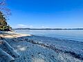
Beddis Beach, Salt Spring Island
-
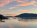
Vesuvius, Salt Spring Island


See also
 In Spanish: Isla Saltspring para niños
