
Mayne Island facts for kids
Quick facts for kids
Mayne Island
|
|
|---|---|
|
Island
|
|

Village Bay, Mayne Island's ferry dock
|
|

The Southern Gulf Islands, including Mayne.
|
|
| Country | Canada |
| Province | British Columbia |
| Regional District | Capital |
| Area | |
| • Total | 21 km2 (8 sq mi) |
| Population | |
| • Total | 1,300+ |
| Time zone | UTC−8 (PST) |
| • Summer (DST) | UTC−7 (PDT) |
| Postal Code |
V0N 2J0
|

Mayne Island is a beautiful island in British Columbia, Canada. It's about 21 square kilometers (8 square miles) and is part of the sunny Gulf Islands. Mayne Island is located right in the middle of the Lower Mainland (where Vancouver is) and Vancouver Island. Over 1,300 people call Mayne Island home. The highest point on the island is Mount Parke, which stands 255 meters (837 feet) tall.
Contents
Island History: Early Days
Mayne Island was first home to the Tsartlip First Nation people long before Europeans arrived. You can still find signs of their history on the island, like ancient shell piles called middens. Old tools and artifacts have also been found. One important discovery was a huge 2-ton stone bowl, which was sadly stolen twice, once in 1982 and again in 2007.
In 1794, Captain George Vancouver, a famous explorer, camped at Georgina Point. His crew left behind a coin and a knife, which were found by settlers more than a century later.
Later, in 1857, Captain George Richards of the Royal Navy explored the area. He was sailing on a ship called HMS Plumper. He named the island after his friend, Lieutenant Richard Charles Mayne. Mayne's father was the first head of the London police force. Captain Richards's journals, along with those of Lieutenant Henry Spencer Palmer, are very important for understanding the early history of British Columbia.
Gold Rush Era
From 1858 to 1860, during the Fraser Canyon Gold Rush, many miners from Vancouver Island would gather on Mayne Island. From there, they would row across the Georgia Strait to the mainland of British Columbia, hoping to find gold. The first settlers officially claimed land in the Miners Bay area in 1859.
In the late 1800s, Mayne Island became a very important place for all the Gulf Islands. It was a busy center for trade and social gatherings. The port at Miners Bay was always full of ships because of Active Pass. This is a narrow, winding waterway between Mayne Island and Galiano Island. Today, Active Pass is the main route for ferries traveling between the mainland and Vancouver Island.
The historic village of Miners Bay is still the main business area on the island. The yearly Fall Fair is still held at the old Agricultural Hall, just like it has been for many years. Miners Bay is also home to the Springwater Lodge, which was built in 1892. It's the oldest hotel in British Columbia that has been open continuously. Active Pass is still busy with marine traffic, which is a big contrast to the quiet roads in the island's center. Village Bay, where the BC Ferries terminal is, has several old buildings from the late 1800s and early 1900s. Active Pass was named after an American survey ship called USCS Active, which was the first steamship to travel through it.
Japanese-Canadian Community
The Japanese-Canadian community on Mayne Island played a big part in the island's economy and social life from the early 1900s until World War II. They had strong connections with the European-Canadian population throughout the Gulf Islands. They were involved in important businesses, like greenhouse farming.
However, in 1942, during World War II, the Canadian government forced Japanese Canadians living on Mayne Island to leave their homes. They were sent to special camps, like New Denver, or moved to Southern Alberta to work on sugar beet farms. These rules about where Japanese Canadians from the coast could live lasted even after the war ended, until April 1949. At that time, all restrictions were lifted, and Japanese Canadians were given full citizenship rights.
Sadly, all the properties belonging to Japanese Canadians, including their homes, land, and fishing boats, were taken by the government. Even though they were initially held "in trust," they were later sold without the owners' permission. Because of this, almost all the families never returned to the island after losing their land, belongings, and community. Today, the Japanese Gardens, near Dinner Bay, are a special place dedicated to remembering the Mayne Island's Japanese-Canadian community and their history.
Island Life Today
The Mayne Island community hosts a Farmers' Market every Saturday morning during the summer. Islanders sell fresh local produce, handmade crafts, delicious baked goods, and beautiful artwork.
Getting Around Mayne Island

BC Ferries offers regular ferry services for vehicles and passengers. You can catch a ferry to Mayne Island from Tsawwassen (near Vancouver) on the mainland, or from Swartz Bay (near Victoria) on Vancouver Island. Ferries also connect Mayne Island to the other main southern Gulf Islands.
If you prefer to fly, SeaAir Seaplanes has scheduled float plane services to Mayne Island from downtown Vancouver and the Vancouver airport.
Hitchhiking is a common way to get around the island in the summer. There are even special "car stops" along the main roads where people wait for rides.
Island Weather
The warmest month on Mayne Island is August, and the coldest month is December.
| Climate data for Mayne Island (1981–2010) | |||||||||||||
|---|---|---|---|---|---|---|---|---|---|---|---|---|---|
| Month | Jan | Feb | Mar | Apr | May | Jun | Jul | Aug | Sep | Oct | Nov | Dec | Year |
| Record high °C (°F) | 14 (57) |
17 (63) |
19 (66) |
24.5 (76.1) |
30 (86) |
30.5 (86.9) |
32 (90) |
30.5 (86.9) |
29.5 (85.1) |
24 (75) |
16.5 (61.7) |
13.5 (56.3) |
32 (90) |
| Mean daily maximum °C (°F) | 7.3 (45.1) |
8.5 (47.3) |
10.7 (51.3) |
13.8 (56.8) |
17.1 (62.8) |
20.0 (68.0) |
22.5 (72.5) |
22.6 (72.7) |
19.8 (67.6) |
14.1 (57.4) |
9.7 (49.5) |
6.9 (44.4) |
14.4 (57.9) |
| Daily mean °C (°F) | 4.6 (40.3) |
5.2 (41.4) |
6.9 (44.4) |
9.4 (48.9) |
12.2 (54.0) |
14.7 (58.5) |
16.8 (62.2) |
16.9 (62.4) |
14.5 (58.1) |
10.3 (50.5) |
6.8 (44.2) |
4.4 (39.9) |
10.2 (50.4) |
| Mean daily minimum °C (°F) | 1.9 (35.4) |
1.8 (35.2) |
3.0 (37.4) |
4.9 (40.8) |
7.1 (44.8) |
9.4 (48.9) |
11.0 (51.8) |
11.1 (52.0) |
9.1 (48.4) |
6.4 (43.5) |
3.8 (38.8) |
1.8 (35.2) |
6.0 (42.8) |
| Record low °C (°F) | −10 (14) |
−12 (10) |
−5 (23) |
−1.5 (29.3) |
0 (32) |
3.5 (38.3) |
4.5 (40.1) |
5 (41) |
2 (36) |
−4 (25) |
−14 (7) |
−11 (12) |
−14 (7) |
| Average precipitation mm (inches) | 129.9 (5.11) |
87.7 (3.45) |
75.4 (2.97) |
55.3 (2.18) |
44.0 (1.73) |
36.9 (1.45) |
21.2 (0.83) |
23.8 (0.94) |
28.0 (1.10) |
79.9 (3.15) |
135.4 (5.33) |
124.5 (4.90) |
842.0 (33.15) |
| Source: Environment Canada | |||||||||||||
Parks and Beaches to Explore
- The Gulf Islands National Park Reserve is a great place for outdoor fun. You can go boating, kayaking, hiking, watch for wildlife, and have picnics.
- At Bennett Bay, there's an easy 1.5 km (0.9 mi) loop trail that leads to Campbell Point.
- Campbell Point has some amazing old-growth trees and offers views of Georgeson Island.
- Bennett Bay also has a sandy beach perfect for sunbathing and swimming.
- Georgina Point is where you'll find a historic lighthouse. Built in 1885, this lighthouse guides ships into Active Pass. It's a fantastic spot to see orca whales, harbor seals, and many different seabirds.
Images for kids
-
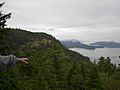
Village Bay from Mt. Sutil
-
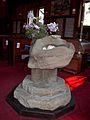
Font, St. Mary Magdalen
-
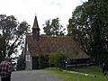
St. Mary Magdalen, Anglican Church
-
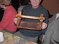
Cedar canoe-bailer belonging to Felix Jack


See also
 In Spanish: Isla Mayne para niños
