Regional District of Nanaimo facts for kids
Quick facts for kids
Nanaimo
|
||
|---|---|---|
|
Regional district
|
||
| Regional District of Nanaimo | ||

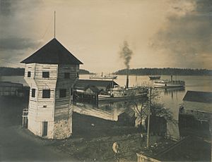
Nanaimo Bastion
|
||
|
||

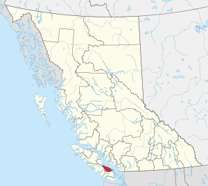
Location in British Columbia
|
||
| Country | Canada | |
| Province | British Columbia | |
| Administrative office location | Nanaimo | |
| Government | ||
| • Type | Regional district | |
| • Body | Board of directors | |
| Area | ||
| • Land | 2,038.04 km2 (786.89 sq mi) | |
| Population
(2016)
|
||
| • Total | 155,698 | |
| • Density | 76.4/km2 (198/sq mi) | |
The Regional District of Nanaimo (RDN) is a special area on the eastern coast of Vancouver Island in British Columbia, Canada. It's like a big neighbourhood that includes cities, towns, and smaller communities. It borders the Cowichan Valley Regional District to the south and the Comox Valley Regional District to the northwest.
The RDN's main office is in Nanaimo. It was officially created on August 24, 1967. In 2016, about 155,698 people lived here. The RDN also runs the Nanaimo Regional Transit System, which helps people get around by bus.
Contents
Cities and Towns in Nanaimo Regional District
The Regional District of Nanaimo includes several cities and towns, each with its own local government. These are called "incorporated municipalities." They work together with the RDN on bigger regional projects.
| Municipality | Type of Government | Population (2016) |
|---|---|---|
| Nanaimo | city | 90,504 |
| Parksville | city | 12,514 |
| Qualicum Beach | town | 8,687 |
| Lantzville | district municipality | 3,601 |
Understanding Electoral Areas
Besides cities and towns, the RDN also has "electoral areas." These are parts of the region that don't have their own city or town government. Instead, people in these areas vote for a representative to join the RDN board. This board helps make decisions for the whole region.
Area A: Cassidy, Cedar, and South Wellington
This area is located on Vancouver Island, southeast of Nanaimo, near the Stuart Channel. It includes the communities of Cassidy, Cedar, and South Wellington. The Nanaimo Airport is also found here.
Area B: Gabriola Island and Nearby Islands
This electoral area is made up of several islands, including Gabriola Island, DeCourcy Island, and Mudge Island. It's a beautiful place with island life.
Area C: Arrowsmith and Benson Region
Located southwest of Nanaimo on Vancouver Island, this area is home to the upper Nanaimo River and the Nanaimo Lakes. You'll also find two mountains here: Mount Benson and Mount Arrowsmith. The community of Extension is in this area.
Area E: Nanoose Bay Community
This area is right on the coast of the Strait of Georgia, between Lantzville and Parksville. It covers the community of Nanoose Bay.
Area F: Alberni Highway Area
Located west of Qualicum Beach and Parksville, this area is crossed by British Columbia Highway 4. It includes communities like Coombs, Errington, Hilliers, Meadowood, and Whiskey Creek. You can also visit Cameron Lake and Cathedral Grove here, which is famous for its huge old-growth trees.
Area G: Mid-Oceanside Communities
This electoral area is on the shore of the Strait of Georgia. It surrounds Qualicum Beach and almost surrounds Parksville. Communities in this area include Dashwood and French Creek.
Area H: Lighthouse Country
This area is also on the coast of the Strait of Georgia, northwest of Qualicum Beach. It's known as "Lighthouse Country." Communities here are Bowser, Deep Bay, Dunsmuir, and Horne Lake.
Population Growth in Nanaimo Regional District
The Regional District of Nanaimo has been growing! In 2021, the population was about 170,367 people. This was a change of about 9.4% from its population of 155,698 in 2016. This means more people are choosing to live in this beautiful part of British Columbia.
How the Regional District of Nanaimo Works
The Regional District of Nanaimo has different jobs to do for the communities it serves. They organize their work into five main "action areas":
- The Regional Federation: This is about how the different parts of the RDN (cities, towns, and electoral areas) work together as one team.
- Strategic and Community Development: This area focuses on planning for the future, like how communities will grow and what services they will need.
- Transportation and Solid Waste: This involves managing how people get around (like bus services) and how garbage and recycling are handled.
- Regional and Community Utilities: This covers important services like water, sewer systems, and other things that keep communities running smoothly.
- Recreation and Parks: This area is all about providing fun activities and places for people to enjoy, like parks, trails, and community centers.
See also
 In Spanish: Distrito regional de Nanaimo para niños
 | Aurelia Browder |
 | Nannie Helen Burroughs |
 | Michelle Alexander |


