
Qualicum Beach facts for kids
Quick facts for kids
Qualicum Beach
|
||
|---|---|---|
|
Town
|
||
| Town of Qualicum Beach | ||

Aerial view of Qualicum Beach
|
||
|
|
||

Qualicum Beach
Location in Vancouver Island

Qualicum Beach
Location in British Columbia
|
||
| Country | Canada | |
| Province | British Columbia | |
| Regional district | Nanaimo | |
| Established | As a village: 1943 | |
| As a town: 1983 | ||
| Area | ||
| • Total | 17.98 km2 (6.94 sq mi) | |
| Elevation | 8 m (26 ft) | |
| Population
(2021)
|
||
| • Total | 9,303 | |
| • Density | 517.5/km2 (1,340/sq mi) | |
| Time zone | UTC-8 (Pacific Standard (PST)) | |
| • Summer (DST) | UTC-7 (PDT) | |
| Forward sortation area |
V9K
|
|
| Area code(s) | 250 | |
Qualicum Beach is a town on Vancouver Island in British Columbia, Canada. In 2021, about 9,300 people lived there. It is located at the base of Mount Arrowsmith, right by the Strait of Georgia. This is on the northeastern coast of Vancouver Island.
Qualicum Beach is a popular place for tourists. Many people visit because of its beautiful nature and its closeness to big cities like Victoria and Vancouver. You can find many cottages along the coast. The town is known for having many older residents. In 2016, the average age was 65.9, making it one of the oldest communities in Canada.
Getting to Qualicum Beach is easy. It is served by the Island Highway and the Island Rail Corridor. There is also a local airport and a ferry nearby that goes to Lasqueti Island.
Contents
- Discovering Qualicum Beach's Past
- Who Lives in Qualicum Beach?
- Getting Around Qualicum Beach
- Qualicum Beach's Natural Environment
- Schools in Qualicum Beach
- Fun Things to Do in Qualicum Beach
- Historic Places to See
- Important Landmarks
- Images for kids
- Famous People from Qualicum Beach
- Other Fun Facts
- See also
Discovering Qualicum Beach's Past
What Does "Qualicum" Mean?
The name "Qualicum" comes from the Pentlatch language. It means "Where the dog salmon (chum salmon) run."
The Qualicum First Nation Story
Qualicum Beach is on the traditional land of the Qualicum First Nation. For a long time, people came to this area. They gathered camas flowers in the spring. These flowers have sweet-tasting bulbs that were traded as a special food. In the fall, people came to catch chum salmon.
The Qualicum First Nation traditionally ate clams, like geoducks and butter clams. The Pentlatch language was spoken here. Sadly, many people of the Qualicum First Nation were lost due to diseases and wars. This also led to the loss of their language.
Early European Settlers Arrive
In May 1856, an explorer named Adam Grant Horne found a path across Vancouver Island. He was with a group of Indigenous guides. The path went from the Qualicum River to the Alberni Inlet. Horne Lake is named after him.
Later, in 1864, a botanist named Robert Brown explored the area. He found it empty because of a widespread illness in 1862. The first European settlers arrived in the 1880s. A road was built from Nanaimo to Parksville in 1886. It was extended to Qualicum in 1894.
Qualicum Beach in the 1900s
A schoolhouse was built in 1912. It taught both elementary and high school students until 1952. Today, this building is an arts center. A train station was built in 1913, and the E&N Railway reached Qualicum in 1914.
H.E. Beasley, a railway official, helped plan the town. He also built the golf course and the Qualicum Beach Hotel in 1913. The hotel was managed by Noel Money. During World War I, the hotel became a hospital. Even the Prince of Wales visited it in 1918! Famous guests like Shirley Temple and Bing Crosby also stayed there. The hotel was taken down in 1969, but the golf course (Memorial Golf Course) is still there.
In 1914, Noel Money's home, the Crown Mansion, was built. It overlooks the Memorial Golf Course. This mansion is now a protected building and works as a hotel.
In the 1920s, Giuseppe Roat, known as the Hermit of Qualicum Beach, moved here. He opened the first museum, called the Crystal Springs Museum of Nature Art. He also had a spring called Crystal Spring where visitors could drink water. Roat bought a lot of land, which is now the Hermitage Park area.
In the 1930s, Alexander Duncan McRae built a fancy family retreat called Eaglecrest. Princess Elizabeth and the Duke of Edinburgh visited in 1951. Eaglecrest later became a resort. After fires in 1969 and 1981, new owners rebuilt it and added a golf course.

A private school for boys, the Qualicum College, opened in 1935. It grew until the 1960s but closed in 1970. The building was a hotel for a while but has now been taken down. Its playing fields are now a housing area.
St. Andrews Lodge, a hotel, was built in 1938. It was very popular during World War 2 with Canadian soldiers.
Qualicum Beach became an official village on May 5, 1942. It changed to a town on January 7, 1983.
Qualicum Beach in the 2000s
In 2002, the main grocery store, Qualicum Foods, was destroyed by a fire. A new store was built in 2003.
New homes for older people were built in 2007 and 2019. Today, Qualicum Beach has five retirement homes.
Trains stopped running in 2011. The old train station is now used as an office.
In 2018, the Town of Qualicum Beach bought St. Andrews Lodge. They wanted to turn the land into a waterfront park. Local residents formed a group to save the Lodge from being torn down, and they succeeded! The Lodge and park are now being fixed up. The Qualicum First Nation gave the new park the name "Saahtlam."
Who Lives in Qualicum Beach?
In 2021, the population of Qualicum Beach was 9,303. Most residents (56.3%) are 65 years old or older. The average age in 2021 was 61.2 years.
Education and Learning
Most adults (92.8%) in Qualicum Beach have finished high school. Many (64%) also have a college certificate, diploma, or degree.
The most common areas of study for people in Qualicum Beach include:
- Business and management
- Engineering and related trades
- Health fields
- Education
- Social sciences and law
Jobs and Money
The average yearly income for households in 2020 was $76,500. About 55% of people work as permanent employees, and 32% are self-employed. Most of the population (65.5%) is not actively looking for work, often because they are retired.
The most common jobs in Qualicum Beach are:
- Sales and service
- Business, finance, and administration
- Trades, transport, and equipment operators
- Education, law, and social services
- Health
- Natural and applied sciences
Different Backgrounds
People in Qualicum Beach come from many different backgrounds. The most common ethnic or cultural origins include:
Beliefs and Religions
In 2021, about 52.6% of people in Qualicum Beach said they had no religion. About 45.7% identified as Christian. Smaller numbers of people followed Judaism, Buddhism, and Islam.
Getting Around Qualicum Beach

Highway 19A runs along the town's shoreline. Highway 19 connects to Highway 4. This highway goes through Cathedral Grove to places like Port Alberni and Tofino on the west coast of Vancouver Island.
Qualicum Flight Center offers scenic flights and flight training. The town does not have a large marina, but there is a boat launch. French Creek Harbour is about 5 kilometers (3 miles) south-east on Highway 19A.
The Via Rail train service, called Malahat, used to stop at Qualicum Beach station from 1979 to 2011. Service stopped in 2011 and has not started again.
Qualicum Beach's Natural Environment
Qualicum Beach covers about 12.45 square kilometers (4.8 square miles). It sits on the Nanaimo lowlands, a flat area between the Georgia Basin and the Beaufort Range. The land was greatly shaped by glaciers about 18,000 to 19,000 years ago.
The Marshall-Stevenson Wildlife Sanctuary is a wetland at the mouth of the Little Qualicum River. It is a great place to see nature.
You can find many animals here, including black-tailed deer, Roosevelt elk, black bears, and cougars. In areas with people, you might also see deer, raccoons, and small rodents.
What is the Weather Like?
Qualicum Beach has a Mediterranean Climate. This means it has cool, wet winters and warm, dry summers. Most of the rain falls between October and April. January temperatures are usually between 1 and 3 degrees Celsius (34-37°F). Summers are warm and dry, with July and August having average high temperatures of 23 degrees Celsius (73°F).
The area has the longest period without frost in Canada, about 180 days a year. This makes it good for farming. It is also part of the Coastal Douglas Fir zone, which has the mildest climate in Canada. The nearby Vancouver Island Ranges block some rainfall, creating a "rain shadow." This area can also support special trees like Garry Oak and Arbutus.
Schools in Qualicum Beach
Qualicum Beach is part of School District 69 Qualicum. There are two elementary schools and one high school in town. Students can also learn through distance education.
Kwalikum Secondary School
Kwalikum Secondary School (KSS) is the only high school in Qualicum Beach. About 700 students attend. The school offers programs like ROAMS, which trains students as outdoor guides. There is also a Golf Academy, a music program, and many sports teams.
Qualicum Beach Elementary School
Qualicum Beach Elementary School is one of two elementary schools. It has about 400 students. Programs include a Mountain Bike Club, a Musical Theatre Club, and the STREAM program, which focuses on technology and new ideas.
Arrowview Elementary School
Arrowview Elementary School is another elementary school in Qualicum Beach. About 300 students go to this school.
Fun Things to Do in Qualicum Beach
Exciting Events All Year!
.jpg)
Farmers Market
The Farmers Market happens every Saturday, all year long. Vendors must "Make it, Bake it, Grow it," meaning everything sold is made, grown, or baked locally. The market started in 1997 with about 20 vendors. Now, it has about 100 vendors and gets about 2,500 visitors each Saturday!
Canada Day
Every July 1st, Qualicum Beach celebrates Canada Day. The town and the Royal Canadian Legion host a Pancake Breakfast, a parade, and other fun activities. The parade usually starts at the Civic Centre.
Family Day
Family Day is an event held on the last Sunday of May. Each year has a different theme. Activities include a pancake breakfast, a parade, and live music.
Brant Wildlife Festival
This is a four-week festival celebrating nature, especially the Brant goose. You can count geese, take tours of the estuary, and watch nature films.
Show & Shine
The Seaside Cruizers Car Club hosts an annual Father's Day Show 'n Shine. Vintage and collectible cars are on display. Over 30,000 people come to see the cars each year! Awards are given for categories like "Best Truck" and "People's Choice."
Seedy Saturday
Seedy Saturday is a yearly gardening event run by volunteers. Visitors can trade or buy seeds and plants, get gardening advice, and chat at the Seedy Cafe. It started in 2002 and had about 2,700 visitors in 2018.
Moonlight Madness
Moonlight Madness is an event in November. Shops stay open late, there's live music, and you can take photos with Santa Claus. It's a great way to support local businesses.
Ocean Mile Swim
The Ocean Mile Swim is an annual swimming race that has been happening for over 60 years. Prizes are given for things like the fastest swimmer and the youngest swimmer.
Fire and Ice Festival (No Longer Held)
The Fire and Ice Festival used to be an annual event. It had a chili cook-off (the fire) and an ice sculpture contest (the ice). It ran for 25 years but was stopped in 2018 because there weren't enough volunteers.
Arts and Culture Spots
The Old School House Arts Centre
The Old School House (TOSH) is an arts center in the middle of Qualicum Beach. It was built as a school in 1912 and served students until 1952. Later, a group of citizens saved the building from being torn down. It reopened as an arts center in 1988. TOSH offers workshops, classes, and has art galleries.

Village Theatre
The Village Theatre was built in 1948 as a movie theater. Now, it is used for live plays. The ECHO Players, a non-profit group, has been performing here for over 45 years. They put on four main shows each season.

Qualicum Beach Museum
The Qualicum Beach Museum opened in 1982. It is in an old power station. The museum has exhibits that show the history of Qualicum Beach.

Parks and Outdoor Fun
Milner Gardens
Milner Gardens is a large 70-acre estate. Members of the royal family have visited twice! Prince Charles and Princess Diana came in 1986. Prince Philip and Queen Elizabeth stayed in 1987. In 1996, Vancouver Island University took over the estate and opened the gardens to the public. You can see very old Douglas fir trees and rare rhododendrons here.
Memorial Golf Course
The Memorial Golf Course opened in 1913. It is the fourth oldest golf course in British Columbia. You can play golf here all year round.
Little Qualicum Falls
Little Qualicum Falls is a provincial park and campground near Qualicum Beach. The waterfalls are surrounded by old forests. Visitors can walk on trails, swim, and camp at this beautiful park.
.jpg)
Parks and Green Spaces
Qualicum Beach has 280 hectares (about 15% of the town) of parks and green spaces.
Beach Front Park
This park is along Highway 19A. It's great for walking and sunbathing. It has picnic tables, benches, restrooms, a boat ramp, and a snack stand.
Brant Viewing Area
Located along Highway 19A, this park has a platform for watching birds and taking photos. It also has picnic tables and benches.
Christleton Park
This park is in the Qualicum Woods neighborhood. It has old native trees, benches, and a playground for kids.
Community Park
This large park is on the west side of downtown. It has a skateboard park, 7 baseball fields, a cricket pitch, a playground, a BMX track, soccer fields, a dog park, walking trails, and restrooms.
Taylor Road Trail
This trail is inside Eagle Ridge Place. It has benches and a nature trail.
General Money Park
This park is home to the Qualicum Beach Train Station, a church, and a steam locomotive. It has benches, flower gardens, a community garden, and fruit trees.
Glassford Square
This square is in the center of town, next to the Public Library and Town Hall. It has a beautiful marble fountain, benches, and an information kiosk.
.jpg)
Grandon Creek
This park is in the western part of Qualicum Beach. It's a heavily forested area with a ravine and fish ladders. There are nature trails and benches. Volunteers help improve the fish habitat here.

Heritage Forest
Heritage Forest is a 50-acre forest in Qualicum Beach. It has very old Douglas fir, western red cedar, and other large trees. This forest is special because it's one of the most diverse forest types in British Columbia. In 1996, there were plans to build houses on this land. But local citizens formed a group to save it. In 2004, with help from the town, they bought the forest. Heritage Forest protects 20% of all coastal Douglas fir forests in British Columbia.

Jubilee Park
This park is on Highway 19A, right by the water. It has benches and picnic tables.
Miraloma Park
Located on Bennett Road, this park is about a third of a hectare and has nature trails.
Seacrest Park
This park is on Seacrest Place. It provides access to the beach and has benches.
Spirit Square
This square is on Memorial Avenue, next to the Community Hall. It has sitting areas and is often used for events.
Yambury Park
This park is on Yambury Road. It's partly forested with nature trails and is popular for dog walking.
Historic Places to See
Qualicum Beach has several places listed on the Canadian Register of Historic Places.
| Name of Heritage Site | Date Constructed | Location |
|---|---|---|
| Kinkade Farmstead | 1882 to 1884 | 3567 Island Highway West, Qualicum Beach |
| Qualicum Beach Train Station | 1914 | 600 Beach Road |
| Qualicum Beach Community Hall | 1933 | 644 Memorial Avenue, Qualicum Beach |
| The Old School House [TOSH] | 1914 | 122 Fern Road West, Qualicum Beach |
| Crown Mansion | 1914 | 292 Crescent Road East, Qualicum Beach |
| Village Theatre | 1948 | 110 2nd Avenue West, Qualicum Beach |
| Thrall Residence | 1915 | 124 2nd Avenue West, Qualicum Beach |
| Qualicum Beach Museum | 1930 | 587 Beach Road, Qualicum Beach |
| The White House | 1913 | 210 Crescent Road West, Qualicum Beach |
| St. Mark's Anglican Church | 1926 | 138 Hoylake Road West, Qualicum Beach |
| Burnham Road Residence | 1920s | 394 Burnham Road, Qualicum Beach |
Important Landmarks
| Site | Location | Remarks |
|---|---|---|
| Qualicum College | 49°21′27″N 124°25′37″W / 49.357494°N 124.426968°W | Built in 1935 |
| Public Library and Town Hall Tower | 49°20′53″N 124°26′38″W / 49.347948°N 124.444027°W | Can be seen from around town. |
| Site of former Eaglecrest Lodge | 49°21′29″N 124°24′09″W / 49.357935°N 124.402506°W | Built by General MacRae. |
| Heritage Forest | 49°21′07″N 124°25′55″W / 49.35205°N 124.432°W | Brown Property Preservation Society. |
| Kwalikum Secondary School | 49°20′54″N 124°26′01″W / 49.348444°N 124.433641°W | |
| Qualicum Beach Airport | 49°20′14″N 124°23′38″W / 49.33722°N 124.39389°W | |
| E and N Railway station | 49°20′58″N 124°26′48″W / 49.349559°N 124.446784°W |
Images for kids
-
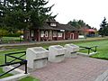
1992 History Monuments, 50th anniversary of Qualicum Beach
-

Qualicum Beach
-
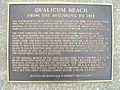
From the beginning to 1913
-
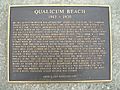
From 1913 to 1930
-
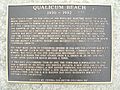
From 1930 to 1992
-
Grandon Creek trail
-

Grandon Creek trail
-
Second Avenue
-
Town Hall and the Library


Famous People from Qualicum Beach
- Noel Ernest Money, a British Canadian general.
- Coral Eswyn (née Ellinor) Lyster, a British Canadian author.
- Alexander Duncan McRae, a Canadian politician.
- Horatio Ray Milner, a Canadian lawyer and businessman.
- Herbert John Welch, a former mayor and politician.
- Harrison Houde, a Canadian singer and actor.
Other Fun Facts
Freedom of the Town
Some people and military groups have been given the special "Freedom of the Town" honor in Qualicum Beach.
People
- Margaret Little in 1998
- James Robert Storey in 2006
- Anna Maria Klees in 2011
- Arthur Norman Skipsey in 2011
- John E. Collins in 2011
- Leo Klees in 2011
Military Units
- 19 Mission Support Squadron, RCAF: May 7, 2022.
A ship in the Royal Navy, HMS Qualicum, was named after the community.
Serval Escape
In October 2022, two Servals (wild cats) escaped from a home in Qualicum Beach. One of them attacked a neighbor's pet cat. The first serval was found quickly, but the second one roamed free for several days, attacking ducks, before it was caught. This event led to requests for a ban on keeping serval cats as pets in British Columbia.
Town Crier
Since 1999, the town's official Town crier is Leonard Mustard.
See also
 In Spanish: Qualicum Beach para niños
