Port Alberni facts for kids
Quick facts for kids
Port Alberni
|
|
|---|---|
| City of Port Alberni | |
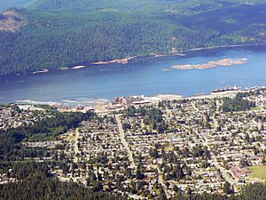
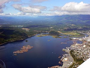
Aerial view of Port Alberni
|
|
| Motto(s):
Gateway to the Pacific West Coast
|
|
| Country | Canada |
| Province | British Columbia |
| Regional district | Alberni-Clayoquot |
| Incorporated | 1912 |
| Area | |
| • Total | 19.76 km2 (7.63 sq mi) |
| Population
(2016)
|
|
| • Total | 17,678 |
| • Density | 894.6/km2 (2,317/sq mi) |
| Time zone | UTC-8 (PST) |
| • Summer (DST) | UTC-7 (Pacific daylight time) |
| Forward sortation area |
V9Y
|
| Area code(s) | 250, 778, 236, 672 |
| Highways | Highway 4 |
| Waterways | Sproat Lake, Alberni Inlet |
| Climate | Csb |
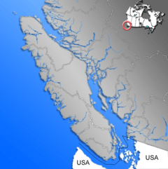
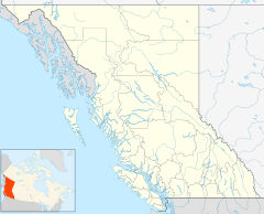
Port Alberni (/ælˈbɜːrni/) is a city on Vancouver Island in British Columbia, Canada. It sits in the Alberni Valley at the top of the Alberni Inlet. This inlet is the longest one on Vancouver Island. Port Alberni is home to about 18,259 people.
The city is the main office for the Alberni-Clayoquot Regional District. You can reach Port Alberni by the Island Highway or by a local airport. The main job here is working with wood and trees.
Contents
- Discovering Port Alberni's Past
- Exploring Port Alberni's Geography
- People and Community in Port Alberni
- Port Alberni's Economy
- Salmon and Fishing in Port Alberni
- Fun Things to Do in Port Alberni
- Hiking Adventures Around Port Alberni
- Getting Around Port Alberni
- Famous People from Port Alberni
- See also
Discovering Port Alberni's Past
Early History and Indigenous Peoples
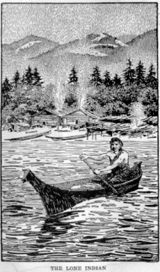
The land around Port Alberni has been home to the Tseshaht First Nation, Hupacasath First Nation, and Nuu-chah-nulth people for thousands of years. Many local names come from the Nuu-chah-nulth language. For example, Somass means "washing" and Nootka means "go around." You can still see ancient rock carvings, called petroglyphs, at Sproat Lake.
The city of Port Alberni is named after Captain Don Pedro de Alberní. He was a Spanish officer who led Fort San Miguel from 1790 to 1792. This fort was located at Nootka Sound on Vancouver Island's west coast.
European Exploration and Settlement
In 1787, Captain Charles William Barkley explored Barkley Sound, which is named after him. His wife, Frances Barkley, was the first European woman to visit this area. Today, a boat named Frances Barkley still travels the Alberni Inlet. It goes from Port Alberni to Bamfield and Ucluelet.
In 1849, the British created the Colony of Vancouver Island. This island was claimed by both Spain and Great Britain, but a treaty made it British land. Later, the island joined the Colony of British Columbia, which became part of Canada in 1871.
In 1856, Adam Grant Horne, a fur trader, found a land route across Vancouver Island. This trail, used by Indigenous people, became known as the Horne Lake Trail. Many early settlers used it to reach the Alberni Valley.
Growth of the Sawmill Industry
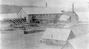
In 1860, a shipping company from London, England, started a sawmill here. They needed wood because the American Civil War stopped wood from the southern United States. Gilbert Sproat and Edward Stamp brought workers and machines to Alberni. Their sawmill opened on May 22, 1861, making 14,000 board feet of wood each day. This was the first mill in British Columbia built to export lumber. The first mill closed, but others opened in the 1880s. The town of Alberni grew around these sawmills.
Gold mining also happened in the area. Small amounts of gold were found in China Creek in 1862. More gold mining took place in the 1890s along the Alberni Inlet. People kept looking for gold in the 1930s and 1960s.
In 1896, a new town called New Alberni was built south of Alberni. It was later called Port Alberni. This new town grew around a new dock for the Canadian Pacific Navigation Company.
Important Events and Changes
From 1900 to 1973, the Alberni Indian Residential School was located just north of Port Alberni. This school was part of a sad time in history for Indigenous peoples. Children were taken from their families and communities. The school closed in 1973 and was torn down in 2009. An art piece called Strength from Within in Port Alberni remembers the survivors and those who suffered.
The Port Alberni Mill opened in 1946. It makes paper products. Another lumber mill, Alberni Pacific Division, is also on the inlet.
On June 23, 1946, a strong earthquake hit the area. It was a 7.3 magnitude earthquake. The center of the earthquake was north of Port Alberni. This earthquake caused a lot of damage in British Columbia.
In 1955, the Alberni Athletics Senior-A Men's Basketball Team had a great year. They won the Canadian Senior Basketball Championships at home. This team was added to the BC Sports Hall of Fame in 2001.
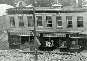
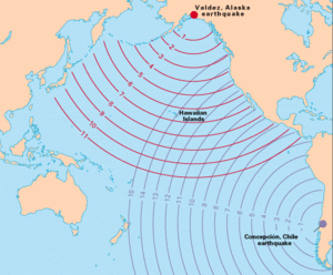
In 1964, Port Alberni was hit by a tsunami after the Good Friday earthquake. The water rose about 30 centimeters in a minute. It reached about 3 meters above the normal high-water mark. About 375 homes were damaged, and 55 were washed away. Luckily, no one was hurt or died.
In 1967, the towns of Alberni and Port Alberni joined together. They formed the single city of Port Alberni.
Today, Port Alberni is a center for local government and services. It has a hospital that helps nearby communities. The city is also working to become a popular place for tourists. People come here for fishing, hiking, kayaking, and mountain biking.
Exploring Port Alberni's Geography
Port Alberni is at the top of the Alberni Inlet. It is next to this natural harbor and the Somass River. The inlet opens into Barkley Sound, which has the Broken Group Islands. These islands are known as one of the best places in the world for kayaking.
Sproat Lake is about 10 kilometers west of the city. The valley is surrounded by mountains like the Beaufort range, Mount Arrowsmith, and Mount Klitsa. Mount Arrowsmith is called Kuth-kah-chulth by the Nuu-Chah-Nulth.
The city has a unique shape because it used to be two separate towns. It has two main downtown areas and many small creeks and ravines. The old town of Alberni is now called "North Port." It is centered at Highway 4 and Gertrude Street. Much of the new growth in Port Alberni has happened in the North Port area.
The old city of Port Alberni is now called "South Port" or "Uptown." You can find it about 3 kilometers south on 3rd and Argyle Street. The Capitol Theatre in South Port was updated in 2004. It now hosts live shows. South Port also has the Harbour Quay, which is a waterfront area with shops, art galleries, and restaurants. The Port Alberni railway station and a farmers market are also here.
The city's West End has a mix of new homes and two First Nations reserves. Many new homes have been built in the West End, especially in the Westporte neighborhood.
Creeks and ravines like Kitsuksis Creek, Cherry Creek, Roger Creek, and Dry Creek flow through the city. The hiking trails along these creeks make Port Alberni a great place to live.
Port Alberni's Climate
Port Alberni has a warm-summer Mediterranean climate. This means it has dry summers and wet winters. Most of the rain falls in winter when cool, moist air comes from the Pacific Ocean. Even though it's on the drier side of Vancouver Island, it still gets a lot of rain.
In summer, temperatures often go above 30 degrees Celsius. This happens about 15 to 30 days a year. This makes Port Alberni one of the warmest places on Vancouver Island in the summer.
The hottest temperature ever recorded in Port Alberni was 42.7 degrees Celsius on June 28, 2021. The coldest temperature ever recorded was -21.7 degrees Celsius on January 14, 1950.
| Climate data for Port Alberni Airport, 1981–2010 normals, extremes 1917–present | |||||||||||||
|---|---|---|---|---|---|---|---|---|---|---|---|---|---|
| Month | Jan | Feb | Mar | Apr | May | Jun | Jul | Aug | Sep | Oct | Nov | Dec | Year |
| Record high °C (°F) | 15.6 (60.1) |
19.4 (66.9) |
24.2 (75.6) |
30.6 (87.1) |
34.1 (93.4) |
42.7 (108.9) |
41.1 (106.0) |
39.4 (102.9) |
35.6 (96.1) |
29.3 (84.7) |
20.6 (69.1) |
16.7 (62.1) |
42.7 (108.9) |
| Mean daily maximum °C (°F) | 5.4 (41.7) |
7.4 (45.3) |
11.5 (52.7) |
14.2 (57.6) |
18.0 (64.4) |
20.7 (69.3) |
24.2 (75.6) |
25.5 (77.9) |
22.3 (72.1) |
14.9 (58.8) |
8.1 (46.6) |
4.5 (40.1) |
14.7 (58.5) |
| Daily mean °C (°F) | 3.0 (37.4) |
3.8 (38.8) |
6.4 (43.5) |
8.7 (47.7) |
12.0 (53.6) |
14.9 (58.8) |
17.4 (63.3) |
18.0 (64.4) |
14.9 (58.8) |
10.0 (50.0) |
5.3 (41.5) |
2.4 (36.3) |
9.7 (49.5) |
| Mean daily minimum °C (°F) | 0.5 (32.9) |
0.1 (32.2) |
1.3 (34.3) |
3.2 (37.8) |
6.1 (43.0) |
8.9 (48.0) |
10.6 (51.1) |
10.5 (50.9) |
7.5 (45.5) |
5.1 (41.2) |
2.5 (36.5) |
0.4 (32.7) |
4.7 (40.5) |
| Record low °C (°F) | −21.7 (−7.1) |
−15.6 (3.9) |
−13.9 (7.0) |
−7.8 (18.0) |
−5.6 (21.9) |
0.0 (32.0) |
2.2 (36.0) |
1.1 (34.0) |
−3.9 (25.0) |
−8.5 (16.7) |
−16.8 (1.8) |
−17.4 (0.7) |
−21.7 (−7.1) |
| Average precipitation mm (inches) | 290.9 (11.45) |
255.3 (10.05) |
190.1 (7.48) |
126.6 (4.98) |
78.5 (3.09) |
55.3 (2.18) |
26.1 (1.03) |
38.5 (1.52) |
49.1 (1.93) |
204.4 (8.05) |
316.6 (12.46) |
276.0 (10.87) |
1,907.3 (75.09) |
| Average rainfall mm (inches) | 275.7 (10.85) |
234.6 (9.24) |
180.6 (7.11) |
125.6 (4.94) |
78.5 (3.09) |
55.3 (2.18) |
26.1 (1.03) |
38.5 (1.52) |
49.1 (1.93) |
203.3 (8.00) |
305.9 (12.04) |
255.9 (10.07) |
1,829 (72.01) |
| Average snowfall cm (inches) | 15.4 (6.1) |
22.2 (8.7) |
10.1 (4.0) |
1.0 (0.4) |
0.0 (0.0) |
0.0 (0.0) |
0.0 (0.0) |
0.0 (0.0) |
0.0 (0.0) |
1.1 (0.4) |
9.6 (3.8) |
20.7 (8.1) |
80.0 (31.5) |
| Average precipitation days (≥ 0.2 mm) | 20.0 | 17.3 | 17.7 | 17.9 | 14.5 | 12.4 | 6.7 | 6.9 | 8.6 | 15.6 | 21.6 | 19.6 | 178.5 |
| Average rainy days (≥ 0.2 mm) | 18.4 | 15.2 | 17.2 | 17.9 | 14.5 | 12.4 | 6.7 | 6.9 | 8.6 | 15.5 | 21.0 | 17.1 | 171.3 |
| Average snowy days (≥ 0.2 cm) | 3.4 | 3.6 | 2.6 | 0.5 | 0.0 | 0.0 | 0.0 | 0.0 | 0.0 | 0.1 | 1.9 | 5.1 | 17.2 |
| Average relative humidity (%) (at 15:00 LST) | 88.3 | 77.5 | 65.8 | 58.6 | 59.4 | 57.7 | 52.7 | 47.7 | 52.5 | 70.8 | 83.6 | 87.5 | 66.8 |
| Mean monthly sunshine hours | 24.3 | 58.1 | 111.8 | 150.5 | 191.4 | 193.8 | 262.8 | 262.6 | 195.8 | 103.1 | 35.0 | 22.1 | 1,611.2 |
| Percent possible sunshine | 9.0 | 20.4 | 30.4 | 36.6 | 40.3 | 40.0 | 53.7 | 58.8 | 51.6 | 30.7 | 12.7 | 8.6 | 32.8 |
| Source: Environment Canada | |||||||||||||
People and Community in Port Alberni
Population and Demographics
In 2021, Port Alberni had a population of 18,259 people. This was a small increase from 17,678 people in 2016. The city covers an area of 19.66 square kilometers.
Because Port Alberni used to be two separate towns, it still has two distinct city centers. This is a unique feature of the community.
Diverse Backgrounds in Port Alberni
Port Alberni is home to people from many different backgrounds. The largest groups are people of European and Indigenous heritage. There are also communities of South Asian, East Asian, and other backgrounds. This mix of cultures makes Port Alberni a diverse place.
| Panethnic group |
2021 | 2016 | 2011 | 2006 | 2001 | 1996 | 1991 | 1986 | |||||||||||
|---|---|---|---|---|---|---|---|---|---|---|---|---|---|---|---|---|---|---|---|
| Pop. | % | Pop. | Pop. | % | Pop. | % | Pop. | % | Pop. | % | Pop. | % | Pop. | % | Pop. | % | |||
| European | 13,975 | 77.81% | 13,290 | 76.73% | 14,400 | 82.81% | 14,295 | 82.51% | 14,320 | 81.67% | 15,235 | 83.48% | 14,875 | 81.42% | 15,175 | 83.72% | |||
| Indigenous | 2,860 | 15.92% | 3,030 | 17.49% | 2,205 | 12.68% | 2,050 | 11.83% | 2,320 | 13.23% | 1,410 | 7.73% | 1,920 | 10.51% | 1,465 | 8.08% | |||
| South Asian | 465 | 2.59% | 495 | 2.86% | 385 | 2.21% | 665 | 3.84% | 590 | 3.36% | 1,165 | 6.38% | 1,025 | 5.61% | 1,170 | 6.46% | |||
| East Asian | 230 | 1.28% | 285 | 1.65% | 205 | 1.18% | 155 | 0.89% | 190 | 1.08% | 275 | 1.51% | 295 | 1.61% | 280 | 1.54% | |||
| Southeast Asian | 140 | 0.78% | 90 | 0.52% | 70 | 0.4% | 30 | 0.17% | 35 | 0.2% | 45 | 0.25% | 45 | 0.25% | 15 | 0.08% | |||
| African | 115 | 0.64% | 55 | 0.32% | 60 | 0.35% | 45 | 0.26% | 50 | 0.29% | 65 | 0.36% | 40 | 0.22% | 0 | 0% | |||
| Latin American | 75 | 0.42% | 20 | 0.12% | 30 | 0.17% | 50 | 0.29% | 20 | 0.11% | 30 | 0.16% | 60 | 0.33% | 20 | 0.11% | |||
| Middle Eastern | 20 | 0.11% | 25 | 0.14% | 0 | 0% | 0 | 0% | 0 | 0% | 0 | 0% | 10 | 0.05% | 0 | 0% | |||
| Other/Multiracial | 80 | 0.45% | 35 | 0.2% | 30 | 0.17% | 35 | 0.2% | 10 | 0.06% | 25 | 0.14% | N/A | N/A | N/A | N/A | |||
| Total responses | 17,960 | 98.36% | 17,320 | 97.97% | 17,390 | 98.01% | 17,325 | 98.73% | 17,535 | 98.8% | 18,250 | 97.17% | 18,270 | 98.63% | 18,125 | 99.36% | |||
| Note: Totals greater than 100% due to multiple origin responses | |||||||||||||||||||
Religious Beliefs in Port Alberni
Many people in Port Alberni do not identify with a religion. However, there are also many Christians, Sikhs, Hindus, and Buddhists. Some people follow Indigenous Spirituality, Islam, or Judaism. This shows the variety of beliefs found in the city.
| Religious group | 2021 | 2011 | 2001 | 1991 | ||||
|---|---|---|---|---|---|---|---|---|
| Pop. | % | Pop. | % | Pop. | % | Pop. | % | |
| Christian | 5,785 | 32.21% | 7,650 | 43.98% | 9,300 | 53.04% | 12,000 | 65.68% |
| Sikh | 215 | 1.2% | 265 | 1.52% | 425 | 2.42% | 725 | 3.97% |
| Hindu | 125 | 0.7% | 20 | 0.11% | 145 | 0.83% | 225 | 1.23% |
| Buddhist | 110 | 0.61% | 120 | 0.69% | 45 | 0.26% | 50 | 0.27% |
| Indigenous spirituality | 85 | 0.47% | 35 | 0.2% | N/A | N/A | N/A | N/A |
| Muslim | 70 | 0.39% | 0 | 0% | 0 | 0% | 0 | 0% |
| Jewish | 30 | 0.17% | 0 | 0% | 0 | 0% | 15 | 0.08% |
| Other religion | 180 | 1% | 105 | 0.6% | 140 | 0.8% | 30 | 0.16% |
| Irreligious | 11,365 | 63.28% | 9,195 | 52.86% | 7,475 | 42.63% | 5,225 | 28.6% |
| Total responses | 17,960 | 98.36% | 17,395 | 98.04% | 17,535 | 98.83% | 18,270 | 99.28% |
Port Alberni's Economy
The main jobs in Port Alberni are in forestry, fishing, and tourism. For many years, forestry workers in Port Alberni earned very good wages. However, the forestry industry has slowed down recently. This has changed the city's economy.
The forests around Port Alberni have trees like Douglas fir, hemlock, yellow cedar, and western red cedar. Most of the very old forests have been cut down. Now, logging mostly uses younger, "second growth" forests. The Port Alberni Mill, owned by Catalyst Paper, makes a lot of paper each year. There are also other sawmills in the area. Farming is also done in the valley.
Port Alberni is also a stop for people traveling to the west coast of Vancouver Island. This includes places like Ucluelet, Tofino, and Pacific Rim National Park. Travelers often buy supplies in Port Alberni because things are more expensive in those remote areas. This has led to new stores and shopping areas along Highway 4.
The city's location near nature makes it great for eco-tourism. Companies offer activities like kayaking, ATV tours, windsurfing, and glider rides.
Salmon and Fishing in Port Alberni
Volunteers and the Department of Fisheries and Oceans have worked to help salmon in the Alberni Valley. They added a Coho salmon hatchery at the McLean Mill National Historic Site. The Robertson Creek Hatchery on the Stamp River is also very successful. In 2010, Port Alberni was named the "Ultimate Fishing Town" by the World Fishing Network.
Fun Things to Do in Port Alberni
Port Alberni is surrounded by mountains like Mount Arrowsmith. These mountains offer great places for hiking, walking, and mountain biking. You can also see wildlife like deer and black bears.
The city is famous for its fishing. You can find five different types of salmon in its waters. There are also yearly runs of steelhead. Halibut can be caught in the saltwater inlets near the city.
The Robertson Creek Fish Hatchery is a top hatchery on Vancouver Island. It raises chinook salmon, coho salmon, and steelhead. It's a short drive from Port Alberni and you can visit it.
Port Alberni is home to the McLean Mill National Historic Site. You can take a steam train from the harbor downtown to the old sawmill. The historic mill shows how things used to work. The Alberni Valley also has a museum and other attractions like Sproat Lake.
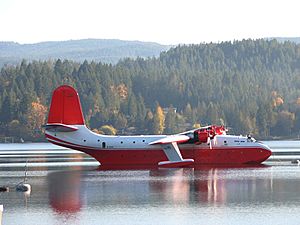
The world's largest aerial firefighting planes, the Martin Mars Water Bombers, used to be based on Sproat Lake. This lake is also a popular spot for swimming and relaxing in the summer. You can also find ancient petroglyphs carved by First Nations people at the lake.
The city has two quays, Harbour Quay and Victoria Quay. These areas along the inlet have shops, restaurants, and art galleries. On some autumn evenings, if the tide is low, you might even see black bears looking for fish near Victoria Quay.
The Alberni Valley Multiplex is in Port Alberni. It's the home of the Alberni Valley Bulldogs, a Junior-A hockey team in the BCHL.
Della Falls, one of Canada's tallest waterfalls (442 meters), can be reached by boat from Great Central Lake or by helicopter. Helicopters are not allowed to land inside Strathcona Provincial Park.
Hiking Adventures Around Port Alberni
The Port Alberni area has many hiking trails. There are over 100 trails for hiking and mountain biking in and around the Alberni Valley. You can also reach high mountain areas like Mount Arrowsmith.
- Horne Lake Trail
- Log Train Trail
- Angler's Trail at Stamp River
- Rogers Creek Trail
- Inlet Trail
- Labour Day Lake Trail
- Greenmax Anglers Trail
- China Creek Trail
- Climb Mount Arrowsmith
- Della Falls Trail
- Kitsukis Dyke Walking Path
- Old Forestry Lookout Trail
- Saddle Trail on Mount Arrowsmith
Getting Around Port Alberni
Air and Road Travel
The Port Alberni Airport (CBS8) is about 11 kilometers northwest of the city. It has a 4,000-foot runway. Several important companies are based at the airport, including Coulson Aircrane.
The main road to Port Alberni is Highway 4. It is also called the Alberni Highway and the Pacific Rim Highway. This highway is the longest east-west road on Vancouver Island, stretching 163 kilometers. The highway to Port Alberni was finished in 1942. It connects Qualicum Beach to Port Alberni, and then continues to Tofino and Ucluelet.
Rail and Port Operations
Port Alberni is also connected by a train line called the Port Alberni Subdivision.
The Port of Port Alberni welcomes large cargo ships from around the world. It also handles tugs, fishing boats, and search and rescue vessels. The Port Alberni Port Authority manages the Alberni Inlet.
Famous People from Port Alberni
Many talented people have come from Port Alberni:
- Paul Boyd, a TV journalist.
- Kim Campbell, who was Canada's 19th Prime Minister. She was the first woman to hold this job.
- George Clutesi, a Tseshaht artist, actor, and writer. He was an expert on First Nations cultures.
- Travis Cross, an Olympic wrestler.
- Wilhelm Alexander, a painter and TV host.
- Paul Cyr, a hockey player drafted by the Buffalo Sabres.
- David Dziurzynski, an NHL and AHL hockey player.
- Leo, Gerry and Myles Fitzgerald, child actors and hockey players.
- Leonard Frank, a photographer.
- Laurent Brossoit, an NHL goaltender.
- Rick Hansen, a Canadian athlete and activist who toured the world in his wheelchair.
- Jim Hiller, a current NHL head coach.
- Eric Jespersen, a bronze medalist at the 1992 Olympics.
- Jamie Lowery, a former soccer player who played in the 1986 World Cup.
- Dakota Morton, the youngest Canadian radio host.
- Kenneth Oppel, a Canadian writer.
- Davis Payne, a hockey player and coach.
- Rob Shick, an NHL official.
- Alec Thomas, a Tseshaht politician and community leader.
- Harry Zolnierczyk, an NHL forward.
- Jim Robson, a famous sports broadcaster.
- Lauren Spencer-Smith, a singer who became popular on TikTok.
See also
 In Spanish: Port Alberni (Columbia Británica) para niños
 | Tommie Smith |
 | Simone Manuel |
 | Shani Davis |
 | Simone Biles |
 | Alice Coachman |


