Mount Arrowsmith facts for kids
Quick facts for kids Mount Arrowsmith |
|
|---|---|

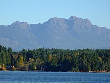
Mount Arrowsmith from Sproat Lake
|
|
| Highest point | |
| Elevation | 1,819 m (5,968 ft) |
| Prominence | 1,429 m (4,688 ft) |
| Listing | Mountains of British Columbia |
| Geography | |
| Parent range | Vancouver Island Ranges |
| Topo map | NTS 92F/02 |
| Climbing | |
| First ascent | John Macoun 1887 |
| Easiest route | scramble |
Mount Arrowsmith is a tall mountain located on Vancouver Island in British Columbia, Canada. It is the highest peak south of Port Alberni. The mountain is mostly made of a type of rock called basalt.
Mount Arrowsmith is a special place! It's part of the Mount Arrowsmith Biosphere Region. This means it's an area recognized by UNESCO for its unique natural environment and for showing how people can live well with nature. Since 2009, about 1,300 hectares (that's about 3,200 acres) of the mountain have also been protected as the Mt. Arrowsmith Massif Regional Park.
Contents
Mountain's History
Mount Arrowsmith has an interesting past.
First Climbers and Explorers
The first person known to climb Mount Arrowsmith was a botanist named John Macoun. He was a scientist who studied plants for the Geological Survey of Canada. He reached the top in 1887.
Later, in 1925, two explorers named Don and Phyllis Munday stood on Mount Arrowsmith's peak. From there, they were the first to see the huge Mount Waddington, another famous Canadian mountain.
How Mount Arrowsmith Got Its Name
Around 1853, a captain named Captain Richards named the mountain. He named it after two famous map makers, Aaron Arrowsmith and his nephew John Arrowsmith.
Before it was named Arrowsmith, the mountain had a different name. In the Coast Salish language, spoken by Indigenous peoples of the area, it was called "Kulth-ka-choolth." This cool name means "jagged face," which describes the mountain's rocky look.
Life Zones on the Mountain
Mount Arrowsmith has three main "biogeoclimatic zones." These are areas with different climates that support different types of plants and animals.
- Coastal Western Hemlock Zone: On the western side of the mountain, which gets a lot of wind and rain, this zone goes up to about 1,050 meters (3,440 feet). You'll find lots of Western Hemlock trees here.
- Mountain Hemlock Zone: Above the Coastal Western Hemlock zone, this area starts around 1,050 meters and goes up to about 1,300 meters (4,300 feet). It's a continuous forest. Higher up, it becomes more like a park with scattered trees.
- Alpine Tundra Zone: This is the highest zone, starting around 1,600 meters (5,200 feet). It's very cold and windy here, so only small plants and mosses can grow. There are no tall trees.
The eastern side of the mountain is a bit warmer because it gets more sunshine. This means that all these zones are found about 50 meters (160 feet) higher up on the eastern slopes compared to the western slopes.
 | Jackie Robinson |
 | Jack Johnson |
 | Althea Gibson |
 | Arthur Ashe |
 | Muhammad Ali |


