Mount Waddington facts for kids
Quick facts for kids Mount Waddington |
|
|---|---|
 |
|
| Highest point | |
| Elevation | 4,019 m (13,186 ft) |
| Prominence | 3,289 m (10,791 ft) |
| Listing |
|
| Geography | |
| District | Range 2 Coast Land District |
| Parent range | Waddington Range |
| Topo map | NTS 92N6 Mount Waddington |
| Climbing | |
| First ascent | 1936 by Fritz Wiessner and William House |
| Easiest route | Rock/ice climb |
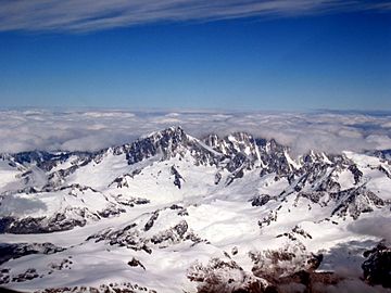
Mount Waddington, once known as Mystery Mountain, is the tallest peak in the Coast Mountains of British Columbia, Canada. Even though it is not as tall as Mount Fairweather or Mount Quincy Adams, which are on the border with Alaska, Mount Waddington is the highest mountain completely inside British Columbia.
This mountain and the Waddington Range around it are in the middle of the Pacific Ranges. This area is very remote and has extremely rugged mountains and river valleys. Despite not being far north, Mount Waddington has very cold, Arctic-like weather. It offers some of the most challenging climbing adventures in North America. The area is also known for its amazing mountain views.
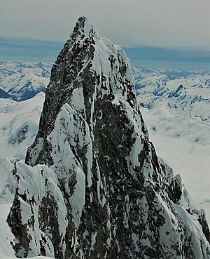
Mount Waddington's sharp peak is about 4,019 meters (13,186 feet) high. It is only about 32 kilometers (20 miles) from sea level at the ends of Bute and Knight Inlets. Nearby, the deep valleys of the Homathko and Klinaklini Rivers are like a deeper version of the Grand Canyon. The landscape here is so dramatic that it has been compared to the Himalayas.
The Mount Waddington Regional District is named after this mountain. This district includes the coastal areas near the Waddington Range and parts of northern Vancouver Island.
Contents
How Mount Waddington Was Discovered
In 1925, while exploring Vancouver Island, Don and Phyllis Munday saw a very tall peak. They thought it might be taller than Mount Robson, which was then considered the highest peak entirely in British Columbia. Don Munday noted that the peak was in an unexplored area on their map. While it's debated if they actually saw Mount Waddington from that far away, they definitely saw a peak in the Waddington Range. This sighting inspired them to explore the area.
For the next ten years, the Mundays went on several trips to try and climb this mountain. They called it "The Mystery Mountain." In 1927, they measured its height at 4,042 meters (13,260 feet) using triangulation. In 1928, they reached a lower peak, but decided the main summit was too dangerous. Based on their suggestion, the Geographical Names Board of Canada named it Mount Waddington. It was named after Alfred Waddington, who had proposed building a road and later a railway through the Homathko River valley to Bute Inlet.
In the summer of 1934, two different groups tried to climb the mountain. The first group from Winnipeg tried to climb the northwestern side. They faced many challenges, including building a bridge over Nude Creek. They reached the Tiedemann Glacier and then the shoulder of Mount Waddington at 3,200 meters (10,500 feet). They tried for the summit on June 28, but bad weather and difficult conditions forced them to turn back. They were only about 180 meters (590 feet) from the top.
The second group, from British Columbia, tried climbing from the southeast. Their climb ended sadly when one climber, Alec Dalgleish, fell to his death from the southeast ridge. In 1935, a group from the Sierra Club of California made three more attempts. They failed on the south face due to storms, bad conditions, and falling ice. Two climbers did reach the northwest summit (which the Mundays had climbed), but they could not go further.
The First Successful Climb
On July 4, 1936, climbers Fritz Wiessner, Bill House, Elizabeth Woolsey, and Alan Willcox arrived at the head of the Knight Inlet. For the next twelve days, they carried supplies to their base camp on the Dais Glacier. Another climbing group joined them there. Wiessner and House agreed to let the other group try for the summit first, but they could not find a way up the south face.
On July 20, Wiessner and House tried to climb a large couloir (a steep gully) between the main summit and the northwest peak. It was a fast way up, but they couldn't move onto the main south face because the rock was too unstable. They had to go back to base camp.
Early the next morning, July 21, they started climbing a different couloir to the right of the face. Good weather had cleared most of the snow, making climbing easier. They followed the couloir's left branch to a snow patch in the middle of the face. The last 300 meters (1,000 feet) of the south face were very challenging, with "sheer forbidding-looking rocks" as Wiessner described them. Wiessner led several difficult sections, including climbing overhanging rocks.
After climbing for many hours, they reached a ledge just below the southeastern ridge. This was 9 hours after leaving the snow patch. They climbed a short chimney and finally reached the small, snowy top. It had taken them 13 hours from base camp to the summit. They decided it was safer to go back down the same way they came up. They reached their tent on the Dais Glacier at 2 AM. The entire climb to the summit and back to base camp took over 23 hours!
Important Climbs of Mount Waddington
- 1936: The South Face was first climbed by Fritz Wiessner and Bill House.
- 1942: The South Face was climbed a second time by Helmut and Fred Beckey.
- 1960: Elfrida Pigou attempted the Bravo Glacier route but sadly died in an avalanche before reaching the summit.
- 1977: A new way up the South Face was first climbed by Jack Tackle and Kenneth Currens. This was the third time the south face was climbed.
- 2012: The Flavelle-Lane Route saw the first solo climb of the peak by Colin Haley.
Weather and Climate
The Waddington Range is famous for its wild and unpredictable weather. This is because it gets the full force of the warm, wet winds that blow in from the Pacific Ocean onto the British Columbia Coast. Mount Waddington is the highest point in this area. The amount of rain and snow here is among the highest in the Coast Mountains. The peak has an ice cap climate (which means it's always very cold, like the North and South Poles).
| Climate data for Mount Waddington Peak 1981-2010 (51.372 -125.262) | |||||||||||||
|---|---|---|---|---|---|---|---|---|---|---|---|---|---|
| Month | Jan | Feb | Mar | Apr | May | Jun | Jul | Aug | Sep | Oct | Nov | Dec | Year |
| Mean daily maximum °C (°F) | −9.6 (14.7) |
−10.4 (13.3) |
−9.8 (14.4) |
−8.5 (16.7) |
−4.6 (23.7) |
−2.1 (28.2) |
1.0 (33.8) |
1.7 (35.1) |
−0.2 (31.6) |
−4.8 (23.4) |
−9.0 (15.8) |
−9.9 (14.2) |
−5.5 (22.1) |
| Daily mean °C (°F) | −12.6 (9.3) |
−13.8 (7.2) |
−13.6 (7.5) |
−12.1 (10.2) |
−8.1 (17.4) |
−5.2 (22.6) |
−2.1 (28.2) |
−0.8 (30.6) |
−2.3 (27.9) |
−7.6 (18.3) |
−12.2 (10.0) |
−13.2 (8.2) |
−8.6 (16.5) |
| Mean daily minimum °C (°F) | −15.6 (3.9) |
−17.3 (0.9) |
−17.3 (0.9) |
−15.7 (3.7) |
−11.7 (10.9) |
−8.3 (17.1) |
−5.1 (22.8) |
−3.2 (26.2) |
−4.3 (24.3) |
−10.3 (13.5) |
−15.4 (4.3) |
−16.5 (2.3) |
−11.7 (10.9) |
| Average precipitation mm (inches) | 592 (23.3) |
382 (15.0) |
403 (15.9) |
349 (13.7) |
123 (4.8) |
115 (4.5) |
130 (5.1) |
144 (5.7) |
164 (6.5) |
676 (26.6) |
721 (28.4) |
586 (23.1) |
4,385 (172.6) |
| Source: http://www.climatewna.com/ClimateBC_Map.aspx | |||||||||||||
In 2010 and again in 2023, scientists drilled into the ice at Combatant Col. This is a saddle (low point) between Mount Waddington and Combatant Mountain. They did this to get ice cores, which are like frozen records of the climate and environment from the past few hundred years. The 2023 core went 219 meters (719 feet) deep, reaching almost to the bottom of the ice.
How to Get to Mount Waddington
Reaching Mount Waddington can be a long journey. One way is to start from Vancouver. Most of this trip involves a long boat ride through the Strait of Georgia and the Knight Inlet, which can take up to three days. A shorter boat trip can be taken from Port McNeill, British Columbia. This town on Vancouver Island can be reached by plane or road from Victoria, making the boat journey less than a day.
Another way to get there is by using trails and rough roads from the Chilcotin side of the mountain range. You can access these routes from BC Highway 20, starting from Williams Lake. You would leave the main road to Bella Coola at Tatla Lake to connect to the Homathko River. From there, you would follow a side creek or glacier. This inland route is also used to reach the nearby Niut and Pantheon Ranges.
Mount Waddington is a very popular place for mountain climbers. It is the highest peak in the Coast Mountains and offers a very challenging climb. Its shape and difficulty have been compared to Mont Blanc in Europe.
See also
 In Spanish: Monte Waddington para niños
- List of mountain peaks of North America
- Franklin Glacier Complex
 | Jewel Prestage |
 | Ella Baker |
 | Fannie Lou Hamer |


