Knight Inlet facts for kids
Knight Inlet (called Tsawatti by the Kwakʼwala people) is a very long and important inlet on the coast of British Columbia, Canada. It's like a deep, narrow arm of the ocean that reaches far inland, also known as a fjord. Knight Inlet is one of the biggest inlets in the southern part of British Columbia's coast. It's special because its water flows out into Queen Charlotte Strait, which is different from some other inlets nearby that flow towards Vancouver. The mouth of the inlet is near the Kwakwakaʼwakw community of Memkumlis on Village Island.
Quick facts for kids Knight Inlet |
|
|---|---|

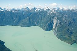
Aerial view of Knight Inlet
|
|
| Location | Mount Waddington RD, British Columbia, Canada |
| Coordinates | 50°41′01″N 125°52′29″W / 50.68361°N 125.87472°W |
| Type | Fjord |
| Native name | Tsawatti Error {{native name checker}}: parameter value is malformed (help) |
| Ocean/sea sources | Pacific Ocean |
Contents
Where is Knight Inlet Located?
The entrance to Knight Inlet is east of Malcolm Island and the fishing town of Port McNeill. This town is on Vancouver Island. The inlet is also just north of where Johnstone Strait ends. Johnstone Strait is a body of water that separates Vancouver Island from many smaller islands and the mainland.
Size and Features of Knight Inlet
Knight Inlet is one of the longest inlets on the British Columbia Coast. It stretches for about 125 kilometers (about 78 miles). On average, it is about 2.5 kilometers (about 1.5 miles) wide.
The large amount of water in the inlet creates strong currents and rough waters near its mouth. This happens especially when the tides change. Also, strong winds often blow out of the inlet from the Interior Plateau of British Columbia. These winds can be dangerous for small boats in the Queen Charlotte Strait.
Rivers and Glaciers Feeding the Inlet
The Klinaklini River flows into Knight Inlet. This river starts on the western edge of the Chilcotin Plateau. It gets its water from the huge Klinaklini Glacier. This glacier is one of the main "tongues" of the Ha-Iltzuk Icefield. The Ha-Iltzuk Icefield is one of the biggest ice caps in the southern Coast Mountains. It is also home to the Silverthrone Caldera, which is a large volcanic bowl.
History of Knight Inlet's Name
The inlet was first mapped in 1792 by William Robert Broughton. He was the second-in-command to George Vancouver during his expedition from 1791 to 1795. Broughton named the inlet "Knights Channel" after John Knight (Royal Navy officer). Broughton and Knight had been captured together by American forces during the American Revolution. They were held as prisoners until they were released in a prisoner exchange.
Early Spanish explorers also mapped this inlet. They called it Braza de Vernaci.
See also
 In Spanish: Knight Inlet para niños
 | Lonnie Johnson |
 | Granville Woods |
 | Lewis Howard Latimer |
 | James West |


