Silverthrone Caldera facts for kids
Quick facts for kids Silverthrone Caldera |
|
|---|---|
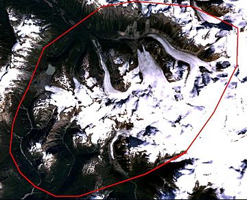
The approximate outline of the Silverthrone Caldera
|
|
| Highest point | |
| Elevation | 3,160 m (10,370 ft) |
| Listing | List of volcanoes in Canada List of Cascade volcanoes |
| Geography | |
| Location | British Columbia, Canada |
| Parent range | Pacific Ranges |
| Geology | |
| Age of rock | Holocene |
| Mountain type | Caldera complex |
| Volcanic arc/belt | Canadian Cascade Arc Pemberton/Garibaldi Belt |
| Last eruption | Unknown; possibly younger than 1000 |
The Silverthrone Caldera is a huge, possibly active, volcano in southwestern British Columbia, Canada. It is located over 350 kilometres (220 mi) northwest of Vancouver. It's also about 50 kilometres (31 mi) west of Mount Waddington in the Pacific Ranges of the Coast Mountains.
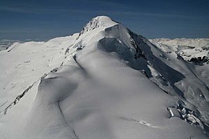
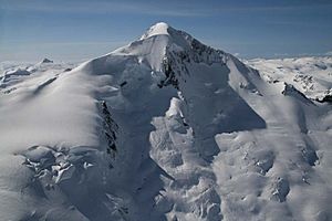
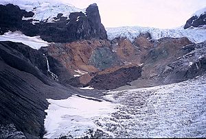
This caldera is one of the largest in western Canada. It measures about 30 kilometres (19 mi) long (north to south) and 20 kilometres (12 mi) wide (east to west). Mount Silverthrone, a worn-down lava dome on the volcano's northern side, is 2,864 metres (9,396 ft) high. It might be the tallest volcano in Canada.
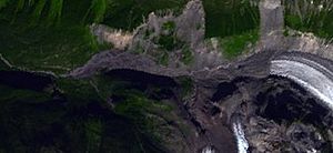
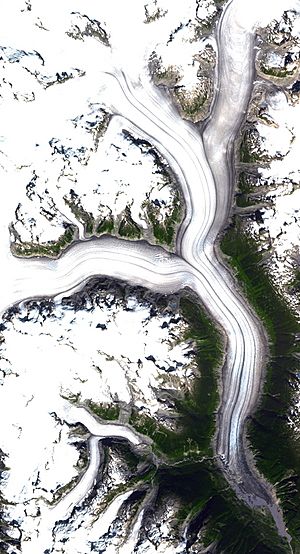
Many large glaciers are found in the Silverthrone area. These include the Pashleth, Kingcome, Trudel, Klinaklini, and Silverthrone glaciers. Most of the caldera is covered by the Ha-Iltzuk Icefield. This is the biggest icefield in the southern Coast Mountains. It is one of five icefields in southwestern British Columbia that have shrunk since the mid-1980s due to global warming. Almost half of this icefield melts into the Klinaklini Glacier, which then feeds the Klinaklini River.
The Silverthrone Caldera is very far away from cities and towns. Not many volcano scientists visit or study it. You can reach it by helicopter. It's also possible to hike there, but it's very difficult. You would need to follow one of the river valleys from the British Columbia Coast or the Interior Plateau.
Contents
How Silverthrone Caldera Formed
Silverthrone is part of the Pemberton Volcanic Belt. This belt is surrounded by groups of rocks that pushed up from deep inside the Earth. The Pemberton Volcanic Belt joins with the Garibaldi Volcanic Belt at another old caldera called Franklin Glacier Complex. The Garibaldi Volcanic Belt is a line of volcanoes and lava fields. It stretches from near the Canada–United States border east of Vancouver.
Scientists believe these rock formations are linked to a volcanic area that was active millions of years ago. This was during the early stages when the Juan de Fuca Plate started sliding under the North American plate. Most of the rocks here are a type called calc-alkaline. They are mainly granite-like rocks and dacite (volcanic rock) pieces.
These rocks are also part of the Coast Plutonic Complex. This is the largest continuous area of granite rock in North America. These rocks stretch about 1,800 kilometres (1,100 mi) along the coast of British Columbia, the Alaska Panhandle, and southwestern Yukon. This area is what's left of a huge volcanic arc called the Coast Range Arc. It formed when the Farallon Plate and Kula Plate slid under North America between the Jurassic and Eocene periods. However, areas like Garibaldi, Meager, Cayley, and Silverthrone are much newer volcanoes.
Inside a Caldera
Like other calderas, Silverthrone formed when the magma chamber (a pool of molten rock) under the volcano emptied out. If a lot of magma erupts, the empty chamber can't hold up the weight of the volcano above it. This causes a circular crack, called a "ring fault," to form around the edge of the chamber. Magma can then push up through these cracks, forming ring dikes. New volcanic vents might also appear above these cracks.
As the magma chamber empties, the middle of the volcano inside the ring fault starts to collapse. This collapse can happen all at once during a huge eruption. Or, it can happen in steps over several eruptions. The total area that collapses can be very large.
Scientists found steep edges between the thick rock at the base of Mount Silverthrone and older rocks nearby. This suggests that the rock at Mount Silverthrone is part of a caldera that filled in. Also, there are many irregular rock intrusions and dikes within this rock, but not in the surrounding older rock. This is more proof of the Silverthrone Caldera. Rocks from rhyolitic lava domes above this base rock were dated to be 750,000 and 400,000 years old. This matches how fast the Coast Mountains have been pushed up and worn down.
Why Do Volcanoes Form Here?
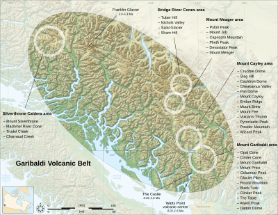
Scientists are still trying to fully understand why volcanoes like Silverthrone Caldera form here. Silverthrone is not above a hotspot, like Nazko or Hawaii. However, it might be a result of the Cascadia subduction zone. This is because rocks like andesite, basaltic andesite, dacite, and rhyolite are found at Silverthrone and along the subduction zone. The way the Earth's plates are moving and how fast they are sliding under each other are important. But the type of rocks at Silverthrone shows it is linked to subduction.
The Cascadia subduction zone is a long line where Earth's plates meet. It separates the Juan de Fuca, Explorer, Gorda, and North American Plates. Here, the oceanic crust (the ocean floor) of the Pacific Ocean is sliding beneath North America. It moves at a rate of 40 millimetres (1.6 in) per year. Hot magma rising above this sinking ocean plate creates volcanoes. Each volcano erupts for a few million years.
This subduction zone is thought to have existed for at least 37 million years. During this time, it has created a line of volcanoes called the Cascade Volcanic Arc. This arc stretches over 1,000 kilometres (620 mi) from Northern California to Vancouver Island. Several volcanoes in this arc could still erupt. All known eruptions in this arc have been in the United States. Two recent ones were Lassen Peak (1914-1921) and the huge eruption of Mount St. Helens in 1980. Canada's most recent major eruption was about 2,350 years ago at the Mount Meager massif.
Silverthrone's Past Eruptions
We don't know much about Silverthrone's past eruptions. However, like other calderas, eruptions at Silverthrone are usually explosive. This means they involve thick magma, glowing clouds of hot volcanic ash, and fast-moving pyroclastic flows. The magma that forms these rocks is called acidic. It has high to medium levels of silica, like in rhyolite, dacite, and andesite. Andesitic and rhyolitic magma often cause two types of explosive eruptions: Plinian and Peléan eruptions. Silverthrone is much younger than its closest large neighbor, the Franklin Glacier Complex, to the east-southeast.
Most of the rocks from Silverthrone's eruptions have been heavily worn away by mountain glaciers. They are now visible on steep slopes from near sea level to heights of almost 3,000 metres (9,800 ft). Most of the volcano seems to have erupted between 100,000 and 500,000 years ago. But there are also newer andesitic and basaltic andesite cones and lava flows from after the last ice age.
Some potassium-argon dates (a way to date rocks) showed ages of 1,000,000 and 1,100,000 years. These came from a large lava flow, at least 10 kilometres (6.2 mi) long, in the Pashleth Creek and Machmell River valleys. This blocky lava flow looks much younger than the dates suggest. Fast-moving glacial streams have only just started to carve a path along its edge. Younger andesitic rocks came from a group of vents, now mostly covered by ice, around the edge of the caldera. At high elevations, broken rocks and cinders from several worn-down cones sit on loose rock from older parts of the volcano. The fact that there are loose glacial deposits under the flow suggests it is less than 1,000 years old.
We don't know the exact Volcanic Explosivity Index (VEI) for Silverthrone Caldera. But its rock type and structure are similar to other calderas that have caused some of the world's most powerful eruptions. Silverthrone is about 30 kilometres (19 mi) long and 20 kilometres (12 mi) wide. For comparison, the Crater Lake caldera in Oregon, United States, is 10 kilometres (6 mi) long and 8 kilometres (5 mi) wide. Such large calderas are usually formed by huge, powerful eruptions that can reach a VEI of 7. These are sometimes called "super-colossal" eruptions.
Current Activity
Silverthrone Caldera is one of eleven Canadian volcanoes that have shown recent earthquake activity. The others include Castle Rock, Mount Edziza, Mount Cayley massif, Hoodoo Mountain, The Volcano, Crow Lagoon, Mount Garibaldi, Mount Meager massif, Wells Gray-Clearwater Volcanic Field, and Nazko Cone. Earthquake data suggests that these volcanoes still have active magma systems deep inside. This means they could erupt again in the future.
While we don't have enough data to be sure, these observations suggest that some of Canada's volcanoes are potentially active. Their hazards could be significant. The earthquake activity is linked to some of Canada's youngest volcanoes. It's also linked to older volcanic centers that have had big explosive eruptions, like the Silverthrone Caldera.
Volcanic Dangers
Volcanic eruptions in Canada rarely cause deaths. This is because they are often in remote areas and don't erupt very often. The only known death from a volcano in Canada happened at the Tseax Cone in 1775. A 22.5-kilometre-long (14.0 mi) lava flow moved down the Tseax and Nass Rivers. It destroyed a Nisga'a village and killed about 2,000 people with volcanic gases.
Towns and cities south of Silverthrone are home to more than half of British Columbia's people. There is a chance that future eruptions could harm populated areas. This makes Silverthrone and other Garibaldi belt volcanoes to the south a big potential danger. Because of this, the Geological Survey of Canada is planning more projects to study Silverthrone and other volcanoes in the Garibaldi belt.
Almost all Canadian volcanoes pose significant dangers. We need hazard maps and emergency plans for them. Volcanoes that show a lot of earthquake activity, like Silverthrone, seem most likely to erupt. A big eruption from any of the Garibaldi belt volcanoes would greatly affect Highway 99. It would also impact communities like Pemberton, Whistler, and Squamish, and possibly Vancouver.
Explosive Eruptions
The explosive nature of past eruptions at Silverthrone Caldera means this volcano could be a threat to communities far away in Canada. A large explosive eruption can produce huge amounts of ash. This ash could seriously affect communities across Canada. Ash clouds could rise hundreds of meters above the volcano. This would be dangerous for air traffic along the coastal airway between Vancouver and Alaska. Volcanic ash makes it hard to see. It can also cause jet engines to fail and damage other aircraft parts.
Also, falling ash could harm the Ha-Iltzuk Icefield around the volcano. Melting glacial ice could cause lahars (mudflows) or debris flows. This, in turn, could threaten water supplies in the Machmell River and other local water sources.
Lava Flows
The Silverthrone area is remote and very rugged. So, the danger from lava flows would be low to medium. Magma with high to medium levels of silica (like in andesite, dacite, or rhyolite) usually moves slowly. It typically covers small areas, forming steep-sided mounds called lava domes. Lava domes often grow as many small flows, less than 30 metres (98 ft) thick, are pushed out over months or years. These flows overlap and usually move only a few meters per hour.
However, lava eruptions at Silverthrone Caldera can be more intense than at other Cascade volcanoes. Lava flows with high to medium levels of silica rarely go more than 8 kilometres (5 mi) from their source. But Silverthrone has produced a 10 kilometres (6 mi) long andesitic lava flow in the Pashleth Creek and Machmell River valleys. There is also evidence that lava flows might have once partly blocked or changed the path of the Machmell River. New activity in this area could change the river's course. This would seriously affect people living or working downstream.
Volcanic Gas
Volcanic gases are various substances that come from volcanoes. These include gases trapped in bubbles inside volcanic rocks. They also include gases dissolved in magma and lava. Or, they can be gases coming directly from lava or indirectly from groundwater heated by volcanic action.
The volcanic gases that are most dangerous to people, animals, farms, and property are sulfur dioxide, carbon dioxide, and hydrogen fluoride. Locally, sulfur dioxide gas can cause acid rain and air pollution downwind from the volcano. Globally, large explosive eruptions can send a huge amount of sulfur particles into the stratosphere. This can lead to lower temperatures on Earth's surface and weaken the Earth's ozone layer. Because carbon dioxide gas is heavier than air, it can flow into low areas and collect in the soil. High levels of carbon dioxide gas in these areas can be deadly to people, animals, and plants.
Monitoring Volcanoes
Currently, the Geological Survey of Canada does not watch Silverthrone closely enough. So, we can't be sure how active the volcano's magma system is. The existing network of seismographs (earthquake detectors) was set up to monitor tectonic earthquakes. These are too far away to give a good idea of what is happening under the caldera. They might detect more activity if the volcano becomes very restless. But this might only give a warning for a large eruption. It might even detect activity only after the volcano has already started erupting.
One way to predict an eruption is to study Silverthrone's past. Every volcano has its own way of erupting, including how strong and how often it erupts. So, its future eruptions are expected to be similar to its past ones. But this method would likely be difficult to use because the volcano is so remote.
The chance of Canada being seriously affected by local or nearby volcanic eruptions suggests that we need better monitoring. It's important to weigh the benefits against the costs when dealing with natural dangers. However, to do this, we need accurate information about the types, sizes, and frequency of hazards. This detailed information doesn't exist for volcanoes in British Columbia or elsewhere in Canada.
Other volcano techniques, like hazard mapping, show a volcano's eruption history in detail. This helps us understand what dangerous activity might happen in the future. Right now, no hazard maps have been made for the Silverthrone Caldera. This is because we don't know enough about it due to its remoteness.
The Geological Survey of Canada has never had a large program just for volcanic hazards. Most information has been gathered slowly and separately by different scientists, like volcanologists. We know the most about the Mount Meager massif. This knowledge will likely grow a lot with a temporary mapping and monitoring project there. We don't know as much about Silverthrone Caldera and other volcanoes in the Garibaldi Volcanic Belt. But some work is being done at least at Mount Cayley. A strong program to map what buildings and roads are near all young Canadian volcanoes would be helpful. Quick hazard assessments at each volcano that has shown recent earthquake activity would also be a good step. This would help us quickly figure out which areas need more attention.
The current network of seismographs for tectonic earthquakes has been around since 1975. But it didn't have many stations until 1985. Except for a few short-term monitoring tests by the Geological Survey of Canada, no volcano monitoring has been done at Silverthrone Caldera or other Canadian volcanoes. This is not as much monitoring as in other countries with volcanoes that have erupted in history.
Active or restless volcanoes are usually monitored using at least three seismographs. These are placed within about 15 kilometres (9.3 mi), and often within 5 kilometres (3 mi), of the volcano. This helps detect activity better and reduces errors in locating earthquakes, especially their depth. Such monitoring helps detect the risk of an eruption. It provides a way to forecast eruptions, which is important for reducing volcanic danger. Currently, the closest seismograph to the Silverthrone Caldera is over 124 kilometres (77 mi) away. As the distance increases and fewer seismographs are used, the ability to predict eruptions decreases. This is because the accuracy of earthquake location and depth measurement goes down.
The earthquake locations in the Garibaldi Volcanic Belt can be off by a few kilometers. In more isolated northern regions, they can be off by up to 10 kilometres (6 mi). The smallest earthquake that can be detected in the Garibaldi Volcanic Belt is about magnitude 1 to 1.5. Elsewhere, it's magnitude 1.5 to 2. At volcanoes that are carefully watched, both located and noticed events are recorded and studied right away. This helps improve our understanding of a future eruption. In British Columbia, undetected events are not recorded or studied right away, nor in an easy-to-access way.
In countries like Canada, it's possible that small groups of early warning earthquakes might not be detected. This is especially true if no events were seen at all. Larger events in bigger groups would be detected. But only a small part of these events would be clear enough to confidently say they are volcanic in nature. It would also be hard to link them to a specific volcano.
 | William Lucy |
 | Charles Hayes |
 | Cleveland Robinson |


