
Whistler, British Columbia facts for kids
Quick facts for kids
Whistler
|
||
|---|---|---|
|
Resort municipality
|
||
| Resort Municipality of Whistler | ||

Whistler panorama
|
||
|
||

Whistler
Location in British Columbia

Whistler
Location in Canada
|
||
| Country | Canada | |
| Province | British Columbia | |
| Region | Sea to Sky Country | |
| Regional district | Squamish-Lillooet | |
| Settled | 1914 by Myrtle and Alex Philip | |
| Incorporated as a resort municipality | 1975 | |
| Government | ||
| • Type | Elected town council | |
| Area
(2021)
|
||
| • Total | 240.00 km2 (92.66 sq mi) | |
| Elevation | 670 m (2,200 ft) | |
| Population
(2021)
|
||
| • Total | 13,982 | |
| • Density | 58.3/km2 (151/sq mi) | |
| Time zone | UTC−08:00 (PST) | |
| • Summer (DST) | UTC−07:00 (PDT) | |
| Postal code span |
V0N 1B0 & V8E
|
|
| Area code(s) | 604 | |
| GNBC Code | JCJHI | |
Whistler is a special kind of town called a resort municipality in British Columbia, Canada. It's found in the Coast Mountains, about 125 kilometers (78 miles) north of Vancouver. Around 13,982 people live there permanently, plus many seasonal workers who come for the busy seasons.
More than two million people visit Whistler every year. They mostly come for alpine skiing and snowboarding in winter. In summer, mountain biking at Whistler Blackcomb is very popular. Whistler's village, designed for walking, has won many awards. Since the 1990s, ski magazines have often named Whistler one of the best places to visit in North America. During the 2010 Winter Olympics, Whistler hosted many of the skiing, luge, skeleton, and bobsled events.
Contents
Exploring Whistler's Past
The Whistler Valley is a natural pathway between two rivers, the Green River and the Cheakamus. It's surrounded by tall, icy mountains. This area has been important for a long time.
First Peoples of Whistler
Before Whistler was built, the land belonged to the Squamish people (Sk̲wx̲wúmesh) and the L̓il̓watú, also known as the Lil'wat First Nation. Their history is deeply connected to the rivers, lakes, and mountains. Long ago, these two nations shared a village called Spoez in Whistler. It was a busy place for trading. However, Spoez was buried by a huge rockslide after the Black Tusk Volcano erupted. After this, both nations continued to use the area for hunting and trapping in warmer months.
European Settlers Arrive
British explorers first surveyed the area in the 1860s. They called the main mountain London Mountain because it was often covered in fog. But people soon started calling the area "Whistler" because of the sound made by the hoary marmots living there.
In the late 1800s, a trail was cut through the valley. It was meant for driving cattle but was very difficult to use. In the early 1900s, trappers and prospectors started setting up small camps. The area became more known when Myrtle and Alex Philip bought land on Alta Lake in 1914. They built the Rainbow Lodge, which became a very popular vacation spot.
When the Pacific Great Eastern Railway was finished in 1914, it made travel from Vancouver much easier. The Rainbow Lodge became famous as a top vacation spot west of the Rocky Mountains. It was mostly a summer place for boating, fishing, and hiking. Other lodges soon opened on the valley's lakes.
Besides tourism, logging was a big industry. Many trees were cut down from the mountain slopes in the first half of the 20th century.
Who Lives in Whistler?
In 2021, Whistler had a population of 13,982 people. This was a growth of about 19% since 2016. Whistler is a diverse community, with people from many different backgrounds living and working there. Most residents identify as having European roots, but there are also many people from Southeast Asia, East Asia, and other parts of the world.
Whistler's Symbols
Whistler received its special symbols, like a coat of arms, in 2016. These symbols represent the town's history and nature. The motto is "Valley of dreams."
Fun Things to Do in Whistler
Whistler is famous for its outdoor activities all year round!
- Winter Fun: In winter, it's a paradise for skiing and snowboarding. You can also try cross-country skiing, ice skating, snowshoeing, and tobogganing.
- Summer Adventures: When the snow melts, mountain biking and hiking become the main attractions. Other popular summer activities include golfing, fishing, and outdoor yoga.
For skiing, runs are marked by difficulty:
- Green circle: Easiest
- Blue square: Medium
- Black diamond: Hard
- Double black diamond: Very hard
Signs on the mountain show you the difficulty of each run. Some chairlifts even have "expert only" signs, meaning most runs from there are black or double black diamonds.
Whistler and the Olympic Games
Before the 1960s, Whistler was a quiet area without roads, water, or electricity. In 1962, four business people from Vancouver wanted to build a ski resort and try to host the 1968 Winter Olympics. They formed the Garibaldi Lift Company, and Whistler Mountain opened in 1966.
Later, the town, then called Alta Lake, was offered the 1976 Winter Olympics. However, the town decided not to host them. The 1976 Olympics ended up in Innsbruck, Austria.
Whistler at the 2010 Winter Olympics


Whistler was the main mountain resort for the 2010 Winter Olympics and Paralympic Games in Vancouver. This was the first time the International Olympic Committee gave this special title to a community. Whistler hosted many events, including alpine skiing, sliding sports (like luge and bobsled) at the Whistler Sliding Centre, and Nordic events at Whistler Olympic Park.
The Whistler Olympic and Paralympic Village housed about 2,400 athletes and coaches during the Games. After the Olympics, this village became a new neighborhood called Cheakamus Crossing.
Getting Around Whistler
Whistler is located on British Columbia Highway 99, also known as the "Sea to Sky Highway." It's about 125 kilometers (78 miles) from Vancouver. This highway connects Whistler to other towns like Squamish and Pemberton.
You can also travel to Whistler by train. The Rocky Mountaineer offers passenger service between Vancouver and Jasper, stopping at the Whistler railway station.
Local buses are provided by the Whistler and Valley Express, which also goes to Pemberton. Shuttle buses from Vancouver International Airport and Downtown Vancouver are also available.
Airports Near Whistler
- Vancouver International Airport (YVR) is the main international airport, about 140 kilometers (87 miles) south of Whistler.
- Pemberton Regional Airport (CYPS) is the closest airport for regular planes, about 38 minutes north of Whistler. It has charter services but no scheduled flights.
- Whistler (Municipal) Heliport (CBE9) is for helicopters. You can get charter flights to Vancouver and Victoria from here.
- Whistler/Green Lake Water Aerodrome (YWS) is a floatplane base on Green Lake. You can take seasonal scheduled flights to Victoria and Vancouver from here.
How to Get to Whistler
Whistler is on the Sea to Sky Highway (Highway 99). This highway stretches from the US border near Surrey, British Columbia all the way north past Whistler.
- To the north of Whistler: Pemberton, British Columbia (about 23 km or 14 miles) and Lillooet, British Columbia (about 122 km or 76 miles).
- To the south of Whistler: Squamish, British Columbia (about 53 km or 33 miles) and Vancouver (about 125 km or 78 miles).
Whistler's Weather
Whistler has a climate with cold, wet winters that get a lot of snow and clouds. Summers are warm and a bit drier. On average, Whistler sees about 11 days a year with temperatures over 30°C (86°F) and about 24 days with temperatures below -10°C (14°F).
| Climate data for Whistler Climate ID: 1048898; coordinates 50°07′44″N 122°57′17″W / 50.12889°N 122.95472°W; elevation: 657.8 m (2,158 ft); 1981–2010 normals |
|||||||||||||
|---|---|---|---|---|---|---|---|---|---|---|---|---|---|
| Month | Jan | Feb | Mar | Apr | May | Jun | Jul | Aug | Sep | Oct | Nov | Dec | Year |
| Record high humidex | 7.8 | 12.8 | 18.8 | 38.7 | 34.8 | 44.0 | 42.2 | 38.8 | 34.6 | 27.3 | 13.7 | 10.3 | 44.0 |
| Record high °C (°F) | 8.9 (48.0) |
14.3 (57.7) |
19.6 (67.3) |
27.8 (82.0) |
35.6 (96.1) |
42.9 (109.2) |
38.8 (101.8) |
38.0 (100.4) |
35.0 (95.0) |
26.8 (80.2) |
13.6 (56.5) |
9.8 (49.6) |
42.9 (109.2) |
| Mean daily maximum °C (°F) | 0.6 (33.1) |
3.2 (37.8) |
7.2 (45.0) |
11.8 (53.2) |
16.4 (61.5) |
19.9 (67.8) |
23.6 (74.5) |
24.0 (75.2) |
19.8 (67.6) |
11.2 (52.2) |
3.5 (38.3) |
−0.2 (31.6) |
11.7 (53.1) |
| Daily mean °C (°F) | −2.1 (28.2) |
−0.5 (31.1) |
2.4 (36.3) |
6.1 (43.0) |
10.1 (50.2) |
13.6 (56.5) |
16.4 (61.5) |
16.5 (61.7) |
12.7 (54.9) |
6.7 (44.1) |
0.9 (33.6) |
−2.8 (27.0) |
6.7 (44.1) |
| Mean daily minimum °C (°F) | −4.9 (23.2) |
−4.2 (24.4) |
−2.3 (27.9) |
0.3 (32.5) |
3.8 (38.8) |
7.2 (45.0) |
9.2 (48.6) |
8.9 (48.0) |
5.6 (42.1) |
2.0 (35.6) |
−1.8 (28.8) |
−5.4 (22.3) |
1.5 (34.7) |
| Record low °C (°F) | −28.2 (−18.8) |
−24.1 (−11.4) |
−18.5 (−1.3) |
−7.7 (18.1) |
−3.4 (25.9) |
−0.7 (30.7) |
0.3 (32.5) |
0.0 (32.0) |
−3.2 (26.2) |
−14.2 (6.4) |
−24.3 (−11.7) |
−29.2 (−20.6) |
−29.2 (−20.6) |
| Record low wind chill | −29.4 | −37.4 | −21.7 | −10 | 0.0 | 0.0 | 0.0 | 0.0 | 0.0 | −22.2 | −31.9 | −30.1 | −37.4 |
| Average precipitation mm (inches) | 176.0 (6.93) |
104.6 (4.12) |
97.6 (3.84) |
75.9 (2.99) |
66.7 (2.63) |
58.9 (2.32) |
44.7 (1.76) |
47.5 (1.87) |
54.9 (2.16) |
154.6 (6.09) |
192.1 (7.56) |
154.1 (6.07) |
1,227.7 (48.33) |
| Average rainfall mm (inches) | 84.7 (3.33) |
50.2 (1.98) |
55.4 (2.18) |
61.2 (2.41) |
65.7 (2.59) |
58.9 (2.32) |
44.7 (1.76) |
47.5 (1.87) |
54.9 (2.16) |
146.7 (5.78) |
131.1 (5.16) |
54.8 (2.16) |
855.9 (33.70) |
| Average snowfall cm (inches) | 103.0 (40.6) |
64.2 (25.3) |
47.4 (18.7) |
15.8 (6.2) |
1.0 (0.4) |
0.0 (0.0) |
0.0 (0.0) |
0.0 (0.0) |
0.0 (0.0) |
7.6 (3.0) |
65.7 (25.9) |
114.0 (44.9) |
418.7 (164.8) |
| Average precipitation days (≥ 0.2 mm) | 18.9 | 14.9 | 16.9 | 16.2 | 15.0 | 13.8 | 10.0 | 9.2 | 10.0 | 17.3 | 19.6 | 18.0 | 179.7 |
| Average rainy days (≥ 0.2 mm) | 10.6 | 8.7 | 11.6 | 14.3 | 15.0 | 13.8 | 10.0 | 9.2 | 10.0 | 16.7 | 14.5 | 7.9 | 142.2 |
| Average snowy days (≥ 0.2 cm) | 13.7 | 10.1 | 9.2 | 4.4 | 0.5 | 0.0 | 0.0 | 0.0 | 0.0 | 1.4 | 9.7 | 14.6 | 63.5 |
| Average relative humidity (%) (at 15:00 LST) | 85.8 | 75.1 | 66.3 | 57.8 | 52.5 | 52.9 | 47.9 | 47.5 | 52.4 | 70.3 | 85.8 | 87.1 | 65.1 |
| Mean monthly sunshine hours | 40.3 | 78.4 | 123.2 | 162.4 | 207.3 | 204.9 | 250.6 | 241.4 | 194.0 | 109.0 | 41.8 | 30.4 | 1,683.8 |
| Percent possible sunshine | 15.1 | 27.6 | 33.5 | 39.4 | 43.4 | 41.9 | 50.8 | 53.8 | 51.1 | 32.6 | 15.3 | 12.0 | 34.7 |
| Source: Environment and Climate Change Canada | |||||||||||||
Plants of Whistler
Whistler has many different types of plants because of its varied climate. You can find everything from dense forests in the valley to alpine tundra high up in the mountains.
The valley floor has a wet climate, perfect for coniferous mixed forests. Here, you'll see lots of western red cedar trees, which are common in the Pacific Northwest rainforests.
Higher up the slopes, the air is a bit drier. You'll find western hemlock and mountain hemlock. There's also a special "Whistler Spruce," which is a mix of two other spruce types. Other trees include Douglas fir, lodgepole pine, and the endangered whitebark pine.
Even higher, near the tree line and in the high alpine areas, you'll see scrub juniper and willow plants. These areas are like the Arctic tundra.
Both the valley and mountain sides have mixed forests. While mostly conifers, there are also some deciduous trees like Pacific dogwood and paper birch.
Schools in Whistler
The School District 48 Sea to Sky runs the public schools in Whistler. There are two elementary schools, Myrtle Phillip Elementary and Spring Creek Elementary. The community also has one high school, Whistler Secondary School. For students who speak French, the Conseil scolaire francophone de la Colombie-Britannique operates a primary school called école La Passerelle.
Whistler in the Media
Whistler has its own local media to keep everyone informed and entertained.
Print News
Pique Newsmagazine is a weekly newspaper published every Friday. There are also tourist guides like FAQ and Whistler Magazine, which come out a few times a year.
Radio Stations
You can listen to several radio stations in Whistler, including:
- FM 88.7: Whistler Information Radio
- FM 90.7: Rock 101 (from Vancouver)
- FM 92.3: CFOX (from Vancouver)
- FM 96.9: Jack FM (from Vancouver)
- FM 100.1: CBC Radio One (from Vancouver)
- FM 101.5: Whistler FM
- FM 102.1: Mountain FM (from Squamish)
- FM 103.1: Ici Radio-Canada Première (from Vancouver)
There's also an internet radio site called freewhistler.com, which shares local music and community news.
TV Channels
Whistler gets TV channels through cable providers like Shaw Cable and Telus TV. Some channels are also available over the air:
- Channel 9 (VHF): Global (from Vancouver)
- Channel 18 (UHF): Independent (from Victoria)
- Channel 21 (UHF): Citytv (from Vancouver)
Movies Filmed in Whistler
Whistler is a popular spot for filmmakers!
- The Whistler Film Festival is held every December, showing many new movies.
- The Crash Reel (2013), a documentary about snowboarder Kevin Pearce, was filmed here.
- Ski School (1991), a comedy, used Whistler as a filming location.
- The X-Files: I Want to Believe (2008) used a glacier above Whistler to look like Antarctica.
- Why Did I Get Married? (2008) was shot on the slopes of Whistler Blackcomb.
- White Fang 2: Myth of the White Wolf (1994), a Disney film, used Whistler as its background.
- The Grey (2011) features a scene filmed at Nita Lake Lodge in Whistler.
- Parts of The Twilight Saga: Breaking Dawn – Part 1 (2011) and The Twilight Saga: Breaking Dawn – Part 2 (2012) were filmed near Whistler.
Images for kids
-
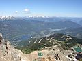
View of Whistler from Whistler Mountain.
-
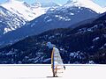
Ice sailing in Whistler.
-
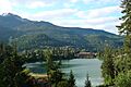
Whistler Mountain as seen from Nita Lake in summer
-
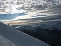
The "Stairway To Heaven" area boundary on Blackcomb Mountain in winter.


See also
 In Spanish: Whistler (Columbia Británica) para niños
