Squamish-Lillooet Regional District facts for kids
Quick facts for kids
Squamish-Lillooet
|
||
|---|---|---|
|
Regional district
|
||
| Squamish-Lillooet Regional District | ||

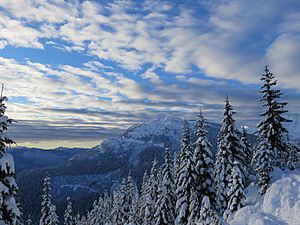
Cloudburst Mountain
|
||
|
||

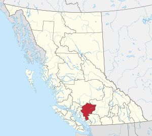
Location in British Columbia
|
||
| Country | Canada | |
| Province | British Columbia | |
| Administrative office location | Pemberton | |
| Government | ||
| • Type | Regional district | |
| • Body | Board of Directors | |
| Area | ||
| • Land | 16,311.62 km2 (6,297.95 sq mi) | |
| Population
(2016)
|
||
| • Total | 42,665 | |
| • Density | 2.62/km2 (6.8/sq mi) | |
| Website | slrd.bc.ca | |
The Squamish-Lillooet Regional District (SLRD) is a special area in British Columbia, Canada. It's like a local government that helps manage services for communities. The SLRD stretches from Britannia Beach in the south to Pavilion in the north.
The SLRD includes four main towns: Lillooet, Pemberton, Whistler, and Squamish. Even though Squamish, Whistler, and Lillooet have more people, the main office for the SLRD is in the Village of Pemberton. This large area covers about 16,353 square kilometers (6,314 square miles) of land.
The southern part of the SLRD is the traditional land of the Squamish people. The northern part is the traditional home of the St'at'imc people. These Indigenous groups have lived here for a very long time.
Population Growth in the SLRD
The number of people living in the Squamish-Lillooet Regional District has been growing steadily. Here's how the population has changed over the years:
- 2016: 42,665 people (an 11.8% increase from 2011)
- 2011: 38,171 people (an 8.4% increase from 2006)
- 2006: 35,225 people (a 6.7% increase from 2001)
- 2001: 33,011 people
Communities of the Squamish-Lillooet Regional District
The SLRD is made up of different types of communities. Some are towns with their own local governments, and others are called "Electoral Areas." These areas are managed directly by the regional district.
Towns and Villages (Incorporated Municipalities)
These are the four main towns and villages in the SLRD, each with its own local government:
| Community | Type of Government | Population (2016) | Growth (2011-2016) |
| Squamish | District Municipality | 19,512 | 13.7% |
| Whistler | Resort Municipality | 11,854 | 20.7% |
| Pemberton | Village | 2,574 | 5.8% |
| Lillooet | District Municipality | 2,275 | -2.0% |
Electoral Areas: Rural Communities
Electoral Areas are parts of the regional district that do not have their own town council. Instead, they are represented by a director on the SLRD Board.
Electoral Area A: Bridge River Valley
This area is in the northern part of the SLRD. It includes the Bridge River valley. The main communities here are Bralorne, Gold Bridge, and Brexton. Other places include Gun Lake and Tyaughton Lake.
- Population in 2016: 186 people.
Electoral Area B: Seton and Anderson Lakes
Area B covers the lower part of the Bridge River valley. It also includes the valleys around Seton and Anderson Lakes. Some communities you'll find here are McGillivray Falls, Seton Portage, Shalalth, and Pavilion.
- Population in 2016: 363 people.
Electoral Area C: Pemberton and Gates Valleys
This area includes the beautiful Pemberton and Gates Valleys. It also covers the valley of the Green River north of Whistler. Communities in this area include Pemberton Meadows, Mount Currie, Birken, and D'Arcy.
- Population in 2016: 1,663 people.
Electoral Area D: Sea-to-Sky Corridor
Area D stretches along the famous Sea-to-Sky Corridor. It includes the valleys of the Cheakamus and Squamish Rivers. Communities here are Britannia Beach, Woodfibre, and Furry Creek.
- Population in 2016: 1,057 people.
 | Kyle Baker |
 | Joseph Yoakum |
 | Laura Wheeler Waring |
 | Henry Ossawa Tanner |


