Mount Silverthrone facts for kids
Quick facts for kids Mount Silverthrone |
|
|---|---|

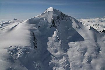
Northeast face of Mount Silverthrone
|
|
| Highest point | |
| Elevation | 2,864 m (9,396 ft) |
| Prominence | 975 m (3,199 ft) |
| Listing | List of volcanoes in Canada List of Cascade volcanoes |
| Geography | |
| Location | British Columbia, Canada |
| Parent range | Pacific Ranges |
| Topo map | NTS 92M/09 |
| Geology | |
| Mountain type | Lava dome |
| Volcanic arc/belt | Canadian Cascade Arc Pemberton/Garibaldi Belt |
| Climbing | |
| First ascent | 1936 Don Munday, Phyllis Munday, H. Hall, Hans Fuhrer |
Mount Silverthrone is a huge, ancient volcano in southwestern British Columbia, Canada. It's not just a mountain; it's what's left of a giant volcanic crater called a caldera. This caldera is about 20 kilometers (12 miles) wide!
Most of Mount Silverthrone's eruptions happened a very long time ago, during the last ice age. Over thousands of years, wind, water, and ice have worn down the volcano, shaping it into what we see today. It stands tall as the highest point in the Ha-Iltzuk Icefield. This icefield is the biggest one in the Coast Mountains, a large mountain range in western North America.
Contents
What is Mount Silverthrone?
Mount Silverthrone is a type of volcano known as a lava dome. Lava domes form when thick, sticky lava slowly pushes out of a volcano's vent. Instead of flowing far, this lava piles up around the vent, creating a dome shape.
The mountain is also part of a larger volcanic area called the Garibaldi Volcanic Belt. This belt is a chain of volcanoes that stretches across southwestern British Columbia. It's part of the bigger Canadian Cascade Arc, which includes many volcanoes in both Canada and the United States.
How does a caldera form?
A caldera is a large, bowl-shaped hollow that forms when a volcano erupts very powerfully. During such an eruption, a huge amount of magma (molten rock) is emptied from the magma chamber beneath the volcano. With nothing to support it, the ground above the chamber collapses inward, creating the caldera. Mount Silverthrone's caldera shows just how massive its ancient eruptions must have been!
Where is Mount Silverthrone located?
Mount Silverthrone is found in the beautiful and rugged Coast Mountains of British Columbia, Canada. It's quite remote, meaning it's far away from cities and towns. The mountain is surrounded by the vast Ha-Iltzuk Icefield.
The Ha-Iltzuk Icefield
An icefield is a large area of interconnected glaciers and snow that covers a mountainous region. The Ha-Iltzuk Icefield is the largest icefield in the Coast Mountains south of the Alaska Panhandle. It's a stunning landscape of ice, snow, and towering peaks. The icefield plays a big role in shaping the land around Mount Silverthrone through erosion.
When did Mount Silverthrone form?
The main eruptions that created Mount Silverthrone happened during the Pleistocene epoch. This was a geological time period that lasted from about 2.6 million to 11,700 years ago. This period is also known as the "Ice Age" because large parts of the Earth were covered by glaciers.
Erosion and its effects
Since its last major eruptions, Mount Silverthrone has been heavily eroded. Erosion is the process where natural forces like wind, water, and ice wear away rocks and soil. Because of this erosion, the original shape of the volcano has changed a lot. What we see today is a "deeply dissected" complex, meaning it has been cut into many valleys and ridges by glaciers and rivers.
Exploring Mount Silverthrone
Mount Silverthrone is a challenging peak to climb due to its remote location and the surrounding icefield. The first recorded climb to its summit was in 1936.
The First Ascent
The first people to successfully reach the top of Mount Silverthrone were Don Munday, Phyllis Munday, H. Hall, and Hans Fuhrer. Don and Phyllis Munday were famous Canadian mountaineers who explored many peaks in British Columbia. Their climb was a significant achievement, showing the adventurous spirit needed to explore such wild and icy places.
 | Stephanie Wilson |
 | Charles Bolden |
 | Ronald McNair |
 | Frederick D. Gregory |

