
Hoodoo Mountain facts for kids
Quick facts for kids Hoodoo Mountain |
|
|---|---|

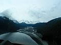
Southern flank in 2004
|
|
| Highest point | |
| Elevation | 1,850 m (6,070 ft) |
| Prominence | 900 m (3,000 ft) |
| Geography | |

Hoodoo Mountain
Location in British Columbia

Hoodoo Mountain
Location in Canada
|
|
| Parent range | Boundary Ranges |
| Topo map | NTS 104B/14 |
| Geology | |
| Age of rock | Pleistocene |
| Mountain type | Stratovolcano |
| Volcanic arc/belt | Northern Cordilleran Volcanic Province |
| Last eruption | 7050 BC (?) |
Hoodoo Mountain is a special kind of volcano in northwestern British Columbia, Canada. It's called a stratovolcano, which means it's shaped like a cone and built up by many layers of hardened lava and ash. It's located about 74 kilometers (46 miles) northeast of Wrangell, Alaska. This mountain has been around for a very long time, since the Pleistocene Ice Age, which ended about 10,000 years ago.
The mountain gets its interesting name from tall, needle-like rock formations called hoodoos. These hoodoos are made of hardened lava and can be as tall as 150 meters (490 feet). They give Hoodoo Mountain a unique look compared to other mountains nearby.
At the very top of Hoodoo Mountain, there's a thick ice cap. Even though it's covered in ice, radar shows that the mountain's summit is naturally flat underneath. Hidden beneath the ice cap is a volcanic crater filled with ice. The summit reaches a height of 1,850 meters (6,070 feet).
Hoodoo Mountain is a large, round lava dome about 6 kilometers (3.7 miles) wide. For most of its history, it has been shaped by glaciers. This means it has had many subglacial eruptions, where lava erupts underneath thick ice. These interactions between the volcano and ice have given Hoodoo Mountain its unique structure.
Contents
Where is Hoodoo Mountain?

Hoodoo Mountain is part of a long chain of volcanoes called the Northern Cordilleran Volcanic Province. This chain stretches from Alaska down into British Columbia. This whole region is also part of the Pacific Ring of Fire. The Ring of Fire is a huge area around the Pacific Ocean where many earthquakes and volcanic eruptions happen.
The volcanoes in this area, including Hoodoo Mountain, form because the Pacific Plate (a giant piece of Earth's crust) is slowly sliding northward. As it moves, it causes the land to stretch and crack, allowing hot magma from deep inside the Earth to rise to the surface. Hoodoo Mountain is one of three large and diverse volcanoes in this province, along with the Mount Edziza volcanic complex and Level Mountain.
Flat-topped Shape
The flat top of Hoodoo Mountain makes it look like a "tuya". A tuya is a special type of subglacial volcano that forms when lava erupts through a very thick glacier or ice sheet. The lava cools quickly against the ice, creating steep sides and a flat top.
However, Hoodoo Mountain is a bit more complex than a typical tuya. Its unusual structure comes from many times the volcano erupted while covered by ice sheets over the last 100,000 years.
Cliffs and Features

Hoodoo Mountain has at least two sets of noticeable cliffs that make it look like it has steps. The bottom of the mountain is surrounded by cliffs that are 100 to 200 meters (330 to 660 feet) tall. The southeastern side of the mountain is smoother because newer lava flows have covered the older land.
There's also a second set of cliffs, 50 to 100 meters (160 to 330 feet) high, that surround the summit. A famous rock formation called The Monument is on the southwestern side. It's a tall dike, which is like a wall of hardened lava that filled a crack in the volcano. It's a leftover from past eruptions that happened under the ice.
The area around Hoodoo Mountain is very high up and has special ecosystems. It's mostly alpine tundra, which means there are no trees because of the high altitude. However, you can find mountain hemlock trees on the lower parts of the mountain.
Glaciers on Hoodoo Mountain
The western, eastern, and northern sides of Hoodoo Mountain are covered by two large valley glaciers: the Hoodoo Glacier and the Twin Glacier. The southern side of the mountain, which goes down to the Iskut River, does not have glaciers. The Hoodoo Glacier is on the western side and feeds the Hoodoo River, while the Twin Glacier is on the northern and eastern sides and feeds the Twin River.
In the past, Hoodoo Mountain was covered by glacial ice that was more than 2 kilometers (1.2 miles) thick! The melting water from these glaciers flows into the Hoodoo and Twin rivers, which then join the much larger Iskut River. This runoff is an important source of fresh water for salmon and fishing areas in the Iskut and Stikine rivers.
Little Bear Mountain
Just north of Hoodoo Mountain is a smaller tuya called Little Bear Mountain. This volcano also formed under ice during the Pleistocene Ice Age. It's made of different types of volcanic rock, including pillow lava (lava that cools quickly underwater) and volcanic glass called obsidian.
Little Bear Mountain is considered a parasitic cone of Hoodoo Mountain. This means it's a smaller volcano that grew on the side of the main volcano. This happens when the main volcano's vent gets blocked, forcing magma to find new paths to the surface through cracks in the side.
Volcanic History
Hoodoo Mountain is a great example of how volcanoes erupt when they are in contact with or underneath ice. Scientists have found that Hoodoo Mountain has had cycles of eruptions, shifting between erupting under ice and erupting when there's no ice. This cycle happens about every 24,000 years and is unique to Hoodoo Mountain among the volcanoes in this region.
More than 90% of Hoodoo Mountain formed during its early history, starting at least 100,000 years ago. During some of its eruptions under ice, the ice could have been more than 2 kilometers (1.2 miles) thick!
The main types of lava from Hoodoo Mountain are called phonolite and trachyte. These lavas are thought to have formed from magma that changed as it moved through the Earth's crust. Scientists estimate that about 17 cubic kilometers (4 cubic miles) of material have erupted from Hoodoo Mountain over time.
Eruption Phases
Hoodoo Mountain has had at least six main periods of eruptions:
- First Phase (85,000 years ago): This was in the Late Pleistocene. Lava flows and domes erupted under more than 100 meters (330 feet) of glacial ice.
- Second Phase (80,000 years ago): Eruptions were no longer completely under the ice, but the volcano was still surrounded by ice at least 800 meters (2,600 feet) thick. The lava flows melted some of the ice and piled up, forming thick cliffs of lava around the base of the mountain.
- Third Phase (80,000 to 54,000 years ago): This phase included explosive eruptions that sent pyroclastic flows (fast-moving currents of hot gas and rock) down the northern and western sides of the mountain. These flows created thick deposits of rock called ignimbrite. This was one of the few explosive eruptions at Hoodoo Mountain.
- Fourth Phase (54,000 years ago): Eruptions were again not under ice. Lava flows from this time covered the pyroclastic deposits from the third phase.
- Fifth Phase (54,000 to 30,000 years ago): This phase involved two types of eruptions that happened under ice. The first created lava domes, and the second happened under thinner ice.
- Final Phase (7,000 to 9,000 years ago): This was an effusive eruption, meaning it produced lava flows without big explosions. These lava flows are still well-preserved and can be seen on the northwest and southwest sides of the mountain. They formed when the area was free of ice.
Recent Activity

Hoodoo Mountain is one of eleven Canadian volcanoes that have shown recent seismic activity (small earthquakes). This suggests that these volcanoes might still have active magma chambers deep inside them, meaning they could erupt again in the future. While the information isn't perfectly clear, it shows that some of Canada's volcanoes are still potentially active.
What are the Dangers?
Hoodoo Mountain could still pose a threat to the nearby area. In 1997, a group of scientists studied the volcano to see how much water was on its summit. They used radar to look through the ice cap, which is 150 meters (490 feet) thick and 3 kilometers (1.9 miles) wide.
If Hoodoo Mountain were to erupt again, especially under its summit ice cap, it could melt a lot of ice. This could cause major floods and mudflows (called lahars) down the Iskut River and Stikine River. Even though few people live right next to the volcano, there are large mining camps about 15 kilometers (9.3 miles) south on the Iskut River. If lava flows were to block the Iskut River, it could cause serious flooding for these mining operations.
Explosive eruptions that create high columns of volcanic ash could also affect air travel between Canada, Alaska, and Asia. However, this is less likely because most of Hoodoo Mountain's eruptions have been lava flows, not big explosions.
Emergency Plans
Canada has a plan called the Interagency Volcanic Event Notification Plan. This plan helps different agencies know what to do if a volcano erupts in Canada or nearby. It mainly focuses on keeping air travel safe, as planes can quickly fly into areas with dangerous volcanic ash. The plan makes sure that all affected agencies are told about volcanic events so they can reroute aircraft and warn people on the ground about possible ash fall.
Monitoring the Volcano
Currently, Hoodoo Mountain is not watched very closely by the Geological Survey of Canada. The existing network of seismographs (instruments that detect earthquakes) is set up to monitor tectonic earthquakes and is too far away to give a clear picture of what's happening deep inside the mountain. It might detect a big increase in activity if the volcano becomes very restless, but this might only give a warning for a large eruption, or even only after an eruption has already started.
Images for kids
-
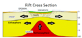
Cross section of a general rift
-
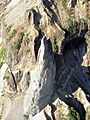
The Monument is one of several hoodoos that have given Hoodoo Mountain its name.
-
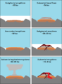
The six eruptive periods of Hoodoo Mountain
-
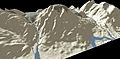
3D model of Hoodoo Mountain
-
Damming of the Iskut River by lava could damage mining infrastructure within the floodplain due to flooding.


.jpg)
.jpg)
