
Level Mountain facts for kids
Quick facts for kids Level Mountain |
|
|---|---|

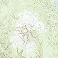
Satellite image of Level Mountain (middle) and Heart Peaks (upper-left corner). This image is approximately 80 km (50 mi) E-W.
|
|
| Highest point | |
| Peak | Meszah Peak |
| Elevation | 2,166 m (7,106 ft) |
| Dimensions | |
| Length | 70 km (43 mi) |
| Width | 45 km (28 mi) |
| Area | 1,800 km2 (690 sq mi) |
| Volume | 860 km3 (210 cu mi) |
| Geography | |

Location in British Columbia
|
|
| Country | Canada |
| Province | British Columbia |
| District | Cassiar Land District |
| Range coordinates | 58°23′26″N 131°24′06″W / 58.39056°N 131.40167°W |
| Topo map | NTS 104J/06 |
| Geology | |
| Formed by | Shield volcano, lava domes, stratovolcano, spatter cones, subglacial volcanoes |
| Age of rock | Neogene-to-Quaternary |
| Volcanic arc/belt | Northern Cordilleran Volcanic Province |
| Last eruption | Unknown |
Level Mountain is a huge complex volcano in northern British Columbia, Canada. It's about 50 km (31 mi) north of Telegraph Creek and 60 km (37 mi) west of Dease Lake. This mountain is the third highest of five big volcanoes in a long chain.
Level Mountain is mostly gently sloped. From its base, it stands about 1,100 m (3,600 ft) tall. The lower part of the mountain looks like a wide shield volcano, while the top has a steeper, more rugged shape. Its large top area has a small mountain range called the Level Mountain Range, with tall peaks and deep valleys. These valleys help small streams flow away from the volcano. Meszah Peak is the only named peak in this range.
This mountain started forming about 15 million years ago, and volcanoes were active until quite recently. There have been four main periods of activity. The first started 14.9 million years ago, creating a large shield volcano with lots of lava. The second period, 7.1 million years ago, formed a complex stratovolcano on top of the shield. Then, 4.5 million years ago, lava domes appeared. The last period, in the past 2.5 million years, saw more lava flows and small volcanic cones.
Level Mountain has three main natural zones. The top is an alpine climate, its sides have Subalpine fir forests, and its base has White spruce forests. Many wild animals used to live here, especially caribou. People arrived in the early 1900s, and scientists began studying the mountain in the 1920s. This remote area is quite dry compared to the Coast Mountains to the west.
Contents
Understanding Level Mountain's Geology
How the Volcano Formed
Level Mountain is part of the Northern Cordilleran Volcanic Province (NCVP). This is a large area of volcanoes stretching from British Columbia into Yukon and Alaska. Volcanic activity here began about 20 million years ago. Many types of volcanoes have formed in the NCVP, like shield volcanoes, lava domes, and cinder cones. Some volcanoes, called subglacial volcanoes, get their shape from forming under ice. The NCVP has over 100 volcanoes and is Canada's most active volcanic area. Eruptions are expected about every 100 years.

Scientists think the volcanoes in this area are caused by the North American Plate slowly stretching apart. As the continental crust stretches, it cracks. Hot, melted rock (magma) rises through these cracks, creating lava flows. Sometimes, thicker magma also reaches the surface, causing explosive eruptions. Two big faults, the Tintina Fault and Denali Fault, run alongside this volcanic area.
The Mountain's Shape and Size
Level Mountain has two main parts: a huge base that looks like a shield volcano and an eroded stratovolcano on top. The lower shield-like part rises from 900 to 1,400 m (3,000 to 4,600 ft) above the surrounding forests. It's made of thin lava flows, usually 2 to 3 m (6.6 to 9.8 ft) thick. This part forms a wide, oval-shaped plateau, about 70 km (43 mi) long and 45 km (28 mi) wide.
Above 1,400 m (4,600 ft), the stratovolcano takes over. Its ridges and peaks form the Level Mountain Range, reaching up to 2,166 m (7,106 ft) at Meszah Peak. So, from far away, Level Mountain looks quite flat, except for the dark peaks on its summit.
Level Mountain is the largest volcano in the NCVP. It covers about 1,800 km2 (690 sq mi) and has a volume of about 860 km3 (210 cu mi). It's so big you can even see it from outer space! Other nearby volcanoes include Hoodoo Mountain and Mount Edziza volcanic complex.
Different Kinds of Rocks
Level Mountain is made of many different types of rocks. The main rocks in the shield base are called ankaramites and alkali basalts. These form lava flows and dikes. The stratovolcano and domes on top are made of rocks like trachybasalts, phonolites, and rhyolites. These can form dikes, welded tuffs, and lava flows.
How Glaciers Shaped the Mountain
Strong glaciation has happened at Level Mountain over the last 5.33 million years. This means much of the mountain was covered by ice during past ice ages. The last ice age ended about 12,000 years ago. Large glaciers carved out U-shaped valleys on the volcano. These valleys now serve as paths for small streams like Dudidontu and Kakuchuya Creek.
The land around Level Mountain has also been lifted up over millions of years. This uplift has caused streams to cut deep valleys, showing that the area is still changing.
Level Mountain's Volcanic History
Level Mountain has erupted on and off for the past 15 million years, making it the longest-lasting volcano in the NCVP. There are more than 20 places where eruptions happened on the mountain. These eruptions produced both thick and thin lavas.
Level Mountain was active during past ice ages. This led to interesting interactions between magma and ice. For example, some lava flows formed under ice, creating unique shapes. It's possible that the heat from Level Mountain affected how the ice sheets moved, similar to how the Grímsvötn volcano in Iceland heats the ice above it today.
The first major volcanic activity at Level Mountain began 14.9 million years ago, building the large shield volcano. This stage ended 6.9 million years ago. A second stage, from 7.1 to 5.3 million years ago, created the stratovolcano on top. Then, from 4.5 to 2.5 million years ago, lava domes formed. The fourth and final stage began in the last 2.5 million years, with smaller volcanic cones and lava flows. This activity might have continued in the last 10,000 years.
Building the Shield Volcano
The shield volcano started with thin lava flows spreading over the land. These eruptions sent lava in all directions from central openings, creating a wide, gently sloped volcano that looked like a warrior's shield. The main lavas were alkali basalts and ankaramites. Because they were very fluid, these lavas could travel long distances. They also erupted from vents on the sides of the volcano.
The Stratovolcano and Lava Domes
After the shield volcano was built, different types of lavas erupted, forming a tall and complex stratovolcano on top of the shield. This stratovolcano grew to be over 2,500 m (8,200 ft) high. Explosive eruptions during this time produced ash and rock fragments. The lava flows could be up to 7 km (4.3 mi) long.
Later, as glaciers eroded the stratovolcano, new eruptions created thick, sticky lava domes. These domes piled up around the volcanic vents.
Recent Volcanic Activity
Volcanic activity continued into the Quaternary period (2.58 million years ago to today). Some eruptions happened on the summit, near the Level Mountain Range. Meszah Peak, the highest point, was active during this time.
Scientists have debated whether there have been very recent eruptions. Some small basaltic vents on the summit might have formed in the last 10,000 years. These eruptions produced small cones and lava flows. There's also an area where hot springs might be active, which could be linked to the volcano.
Two thin layers of volcanic ash, called the Finlay tephras, are found near Dease Lake. They are thought to be from a single volcano and are about 10,000 years old. Level Mountain is one possible source for these ash layers.
Nature at Level Mountain
Plants and Animals Thrive Here

Level Mountain has three main natural zones.
- Below 1,200 m (3,900 ft), you'll find lodgepole pine and bog birch trees.
- Between 1,200 and 1,540 m (3,940 and 5,050 ft), the climate is harsh with strong winds and cold. Bog birch is very common here.
- Above 1,540 m (5,050 ft), it's an alpine tundra with no trees. You'll see plants like dwarf willows and lichens.
Many animals live on Level Mountain, including brown bears, wolves, caribou, mountain goats, and moose. Wolves hunt in the valleys and use the high alpine areas. Brown bears are common at high elevations and might hunt caribou calves. In 1978, over 400 caribou were counted here, but their numbers have been decreasing.
Level Mountain's Climate
The Coast Mountains to the west block most of the moisture from reaching Level Mountain, creating a rain shadow. This means Level Mountain has a relatively dry climate. Because the volcano is mostly flat, the climate doesn't change much across its lower and middle parts.
In winter, it can be hard for some animals to move from high to low elevations due to deep snow. However, at higher elevations (above 1,700 m (5,600 ft)) the wind helps clear snow from ridges. Level Mountain gets less snowfall than the Coast Mountains.
During late May and early June, when caribou calves are born, winds usually come from the south. It's rarely calm. There's a 15–20% chance of snow at 1,370 m (4,490 ft) elevation, and this chance increases higher up.
People and Level Mountain
Early Settlements and History
In the early 1890s, the Hudson's Bay Company built a trail and a trading post called Egnell near Level Mountain. However, the post was soon abandoned because there wasn't much trade.
In the early 1900s, the Egnell Post became a repair station for the long Yukon Telegraph Line. By 1944, a small settlement called Sheslay had grown there, but it has since been abandoned. Today, no one lives within 30 km (19 mi) of Level Mountain, but over 630 people live within 100 km (62 mi) of it.
Studying the Mountain's Secrets

Scientists began studying Level Mountain's rocks in the 1920s. They found different types of lava flows, with some being older than others. For a while, scientists thought Level Mountain might be the source for the lavas in the nearby Tuya volcanic field. However, in the 1940s, a Canadian volcanologist named Bill Mathews discovered that the flat-topped mountains in the Tuya field were actually individual volcanoes that formed under ice. He called these "tuyas." This showed that Level Mountain was a separate, much larger volcano.
In the 1950s and 60s, more detailed mapping of Level Mountain was done using helicopters. In the 1970s, T. S. Hamilton created a detailed map and studied the mountain's lavas, helping us understand its complex history.
How Level Mountain Got Its Name
The name "Level Mountain" refers to the mountain's gently sloping, flat top. It was officially adopted on December 21, 1944. For a short time, the name "Level Mountain Range" was used on maps because cartographers weren't sure what "Level Mountain" referred to. However, "Level Mountain" is still the local name for the entire volcano, and "Level Mountain Range" refers to the steep peaks on its summit.
Visiting Level Mountain
Level Mountain is in a remote area with no roads leading directly to it. The closest road is about 50 km (31 mi) away, connecting Dease Lake to Telegraph Creek. From Telegraph Creek, you can hike about 30 km (19 mi) to reach the volcano.
Small lakes around Level Mountain, like Ketchum Lake, allow access by float plane. The old Yukon Telegraph Trail can also be used to reach the volcano. You can also land a small plane at a runway in Sheslay. For direct access to the Level Mountain Range, you can charter a helicopter from Dease Lake. The flat, high parts of Level Mountain are easy to travel on by horse or on foot during the snow-free months from June to September.
Watching for Volcanic Activity
Level Mountain, like other volcanoes in the NCVP, isn't watched very closely by the Geological Survey of Canada. The Canadian National Seismograph Network monitors earthquakes across Canada, but it's too far away to detect small changes under Level Mountain. It might only detect activity if the volcano becomes very restless or starts erupting. If Level Mountain were to erupt, there are plans in place to help people.
The edges of Level Mountain's lava plateau can be prone to landslides, especially where the ground is steep. There are signs of past mudflows and landslides around the plateau.
Images for kids
-
Topographic map of Level Mountain

