
Heart Peaks facts for kids
Quick facts for kids Heart Peaks |
|
|---|---|

Satellite photo of Heart Peaks (middle)
|
|
| Highest point | |
| Elevation | 2,012 m (6,601 ft) |
| Prominence | 1,012 m (3,320 ft) |
| Geography | |

Heart Peaks
Location in British Columbia
|
|
| Location | British Columbia, Canada |
| Parent range | Nahlin Plateau |
| Topo map | NTS 104J/12 |
| Geology | |
| Age of rock | Neogene-to-Quaternary |
| Mountain type | Shield volcano |
| Volcanic arc/belt | Northern Cordilleran Volcanic Province |
| Last eruption | Unknown |
Heart Peaks, once called the Heart Mountains, is a large mountain in northern British Columbia, Canada. It is about 90 km (56 mi) northwest of Telegraph Creek. This mountain rises high above the flat lands of the Nahlin Plateau.
Heart Peaks is actually a huge shield volcano. It was created over millions of years by many lava flows. Scientists believe it formed over the past 23 million years. However, it is not erupting today. Heart Peaks is part of a long chain of volcanoes in western Canada.
Contents
Understanding Heart Peaks Geology
How Volcanoes Form Here
Heart Peaks is part of the Northern Cordilleran Volcanic Province. This is a long chain of volcanoes stretching from British Columbia into Yukon and Alaska. Here, the Earth's outer layer, called the lithosphere, is slowly pulling apart.
The Earth's surface is made of huge pieces called tectonic plates. These plates are always moving. They can crash into each other or pull apart. When they move, they cause volcanoes and earthquakes. Along the coast of British Columbia, the Pacific Plate is sliding past the North American Plate.
As the Pacific Plate moves north, it causes cracks in the North American continent. Hot, melted rock, called magma, rises through these cracks. When it reaches the surface, it erupts and forms a volcano. This process created the Northern Cordilleran Volcanic Province. It is the most active volcanic area in Canada.
What Heart Peaks Looks Like
The Heart Peaks volcano is shaped like a wide, flat oval. It is made mostly of basalt and trachybasalt rocks. These rocks are up to 430 m (1,410 ft) thick. You can also find pyroclastic rocks here, which are pieces of rock thrown out during eruptions.
Heart Peaks sits west of the even larger Level Mountain volcano. On its western side, there are steep-sided lava domes. These domes are made of rhyolite and trachyte and can be light green or pink. More rhyolite lava domes are found on the top of the mountain.

Heart Peaks is at least 33 km (21 mi) long and 19 km (12 mi) wide at its base. The west and east sides of the volcano are rugged. The north side is smooth, while the south side is more pointed. The highest point of Heart Peaks is 2,012 m (6,601 ft) high. The land around it, the Nahlin Plateau, is about 1,000 m (3,300 ft) high. This means Heart Peaks rises over 1,012 m (3,320 ft) above the land around it.
Many small creeks flow from the volcano. These creeks drain into the Dudidontu and Sheslay rivers nearby. Heart Peaks covers about 275 km2 (106 sq mi). It is the third-largest volcano in the Northern Cordilleran Volcanic Province. Only the Mount Edziza and Level Mountain volcanoes are bigger. Heart Peaks is more than five times larger than Mount Meager massif, which is a big volcano in southwestern British Columbia.
The area around Heart Peaks is mostly wild and undeveloped. The only nearby settlement is Callison Ranch. The mountain's sides have plants and trees, but its wide top is rocky. Because it is so far away, people usually reach Heart Peaks by helicopter. They fly from small towns like Atlin or Dease Lake.
Heart Peaks Eruptive History
When Heart Peaks Erupted

Scientists do not know much about Heart Peaks' past eruptions. This is because it has not been studied in great detail. We do not know its exact age. However, its first volcanic activity happened during the Neogene period. This was between 23 and 2.5 million years ago.
Heart Peaks has had different types of eruptions. It has produced runny, quiet lava flows. It has also had more explosive eruptions with thicker lavas. There is also evidence of "phreatic" eruptions. These happen when hot magma heats groundwater, causing steam explosions. Features from eruptions under ice are also present.
The most recent volcanic activity at Heart Peaks was mostly during the Pleistocene epoch. This was between 2.5 million and 10,000 years ago. It is not clear if there has been any activity in the last 10,000 years (the Holocene epoch). This is because scientists have not found Holocene volcanic rocks there yet. So, the exact date of its last eruption is still a mystery.
The Finlay Tephras Mystery
Heart Peaks is one of four volcanoes that might have erupted the Finlay tephras. Tephras are layers of ash and rock fragments from an eruption. These tephra layers are found across northwestern British Columbia. They might even reach into the Canadian Rockies.
In some areas, two layers of tephra are found between layers of sand, silt, and gravel. These tephras have a similar chemical makeup. This suggests they might have come from the same volcano. Plant fossils found above the youngest tephra layer are about 8,960 to 9,180 years old. This means the Finlay tephras erupted shortly after the last ice age ended.
The Finlay tephras are very similar to rocks from Hoodoo Mountain. Hoodoo Mountain is a flat-topped volcano that formed under ice. Two lava flows from Hoodoo Mountain, erupted about 9,000 to 10,000 years ago, have a similar chemistry to the tephras. However, no tephra from Hoodoo Mountain has been found from that time. So, other volcanoes are also possible sources. Heart Peaks and Level Mountain have not been studied much. It is unknown if they have Holocene-age rocks. Because of this, they are also considered possible sources for the Finlay tephras.
Heart Peaks and People
How Heart Peaks Got Its Name
The mountain was first called Heart Mountains in 1930. It was later renamed Heart Peaks on May 6, 1947. The reason for the name change is not known. Many other mountains in British Columbia also had their names changed around that time.
The name Heart Peaks officially refers to two small peaks on top of the main volcano. Because the whole volcano is one large landmass, some people call it Heart Peak to avoid confusion. In scientific papers and maps, it is sometimes called HP.
Searching for Minerals

People have been searching for minerals on the western side of Heart Peaks since 1980. In 1980, gold-bearing quartz veins were found. These were in an area of altered rock covering more than 3 km2 (1.2 sq mi).
In 1982, scientists took soil samples and rock samples. They also did some digging. In 1983, they used special equipment to survey the area. In 1984, they drilled eight holes to look for minerals. More drilling happened in 1987.
Exploration stopped until 1996. Then, the United States Diamond Corporation did more sampling and drilling. All these explorations happened on the Heart Peaks property. This area covers about 2,867 ha (7,080 acres). It is owned by Colorado Resources Ltd.
Watching for Eruptions
The Geological Survey of Canada does not watch Heart Peaks very closely. This is true for most volcanoes in this region. One reason is that the area is very remote. Also, Canada has not had any major volcanic eruptions in the last few hundred years.
Because of this, monitoring volcanoes is less important than watching for other natural dangers. These include tsunamis, earthquakes, and landslides. No recent earthquakes have been reported at Heart Peaks.
If Heart Peaks were to erupt, there would likely be warning signs. These could include small earthquakes happening weeks or months before. These quakes would probably be too small for people to feel. However, the current network of seismographs is too far away to give a good warning. It might only detect activity once an eruption has already started.
Images for kids
-
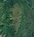
Satellite photo of Heart Peaks (middle)
-
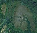
A satellite photo of Heart Peaks (upper-left corner) and nearby Level Mountain (middle). This image clearly shows the large contrast in size between the two volcanoes.
-
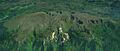
Heart Peaks from the north. The Dudidontu River is in the lower-left corner and the Sheslay River is in the upper-right corner along the Coast Mountains.
-
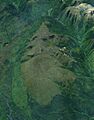
Heart Peaks seen from the west. Mineral explorations have occurred at the circular feature at the bottom centre of this image.
