
Mount Meager massif facts for kids
Quick facts for kids Mount Meager massif |
|
|---|---|

The Mount Meager massif as seen from the east near Pemberton. Summits left to right are Capricorn Mountain, Mount Meager and Plinth Peak.
|
|
| Highest point | |
| Peak | Plinth Peak |
| Elevation | 2,680 m (8,790 ft) |
| Dimensions | |
| Length | 13 km (8.1 mi) |
| Width | 9 km (5.6 mi) |
| Volume | 20 km3 (4.8 cu mi) |
| Geography | |

Location in British Columbia
|
|
| Country | Canada |
| Province | British Columbia |
| District | Lillooet Land District |
| Range coordinates | 50°38′N 123°03′W / 50.63°N 123.05°W |
| Parent range | Pacific Ranges |
| Topo map | NTS 92J/12 |
| Geology | |
| Formed by | Complex volcano |
| Volcanic arc/belt | Canadian Cascade Arc Garibaldi Volcanic Belt |
| Last eruption | 410 BCE ± 200 years |
The Mount Meager massif is a group of volcanic mountains in southwestern British Columbia, Canada. It is part of the Cascade Volcanic Arc, a chain of volcanoes in western North America. The massif is located about 150 km (93 mi) north of Vancouver. Its highest point reaches 2,680 m (8,790 ft) (about 8,793 feet) high.
This mountain group has several eroded volcanic features. These include lava domes, volcanic plugs, and layers of hardened lava. These features form at least six main peaks. Mount Meager itself is the second highest peak in the massif.
The Garibaldi Volcanic Belt (GVB), which includes Mount Meager, has a long history of eruptions. It can be dangerous to people and wildlife. Even though Mount Meager has not erupted in over 2,000 years, a large eruption is still possible. If it happened, emergency teams like the Interagency Volcanic Event Notification Plan (IVENP) would help.
Mount Meager produced Canada's largest volcanic eruption in the last 10,000 years. This happened about 2,400 years ago. An explosive eruption created a volcanic crater on its side. It also sent hot ash, rocks, and gases down the mountain. Today, signs of volcanic activity include hot springs and small earthquakes. The massif has also caused several large landslides. One huge mudslide in 2010 flowed down Meager Creek and the Lillooet River.
Contents
Where is Mount Meager? (Geography)
Location in the Coast Mountains
The Mount Meager massif is located in the Coast Mountains. These mountains stretch for 1,600 km (990 mi) from Vancouver to Alaska. They are about 300 km (190 mi) wide. Deep, narrow inlets called fjords cut through them.
The Coast Mountains greatly affect British Columbia's weather. They block moist air from the Pacific Ocean. This causes heavy rainfall on their western slopes. These areas have some of the most extreme rainfall in North America. This rain helps grow thick forests on the mountains.
Nature and Wildlife Around the Massif
The valleys around Mount Meager have old, tall forests. There are also wetlands with plants like cottonwood, willow, and thimbleberry. Many animals live here, including wolves, wolverine, moose, raptors, black-tailed deer, mountain goats, and waterfowl. Both grizzly and black bears also live in the area.
How Mount Meager Formed (Geology)
The Garibaldi Volcanic Belt

The Mount Meager massif is part of the Garibaldi Volcanic Belt (GVB). This is the northernmost part of the Cascade Volcanic Arc. The GVB has many types of volcanoes. These include cinder cones, calderas, and stratovolcanoes. Some are even subglacial volcanoes, meaning they are under glaciers or ice sheets. All of these have been active in the last 10,000 years.
The most recent explosive eruption in the GVB happened at Mount Meager. It was about 2,400 years ago. This eruption created a clear bowl-shaped crater on the mountain's side.
The Cascade Volcanic Arc
Volcanoes in the Cascade Volcanic Arc form because of something called subduction. This is when one of Earth's large plates, the Juan de Fuca Plate, slides under another, the North American Plate. This happens at the Cascadia subduction zone.
This zone is a 1,094 km (680 mi) long fault zone. It lies about 80 km (50 mi) off the coast of the Pacific Northwest. The plates move slowly, about 10 mm (0.39 in) per year. This movement can cause very large earthquakes, even magnitude 7.0 or higher.
Peaks of the Massif

The Mount Meager massif has six main peaks:
- Plinth Peak: The highest and northernmost peak, at 2,680 m (8,790 ft).
- Mount Meager: 2,650 m (8,690 ft) high.
- Capricorn Mountain: West of Mount Meager, at 2,570 m (8,430 ft).
- Mount Job: West of Capricorn Mountain, at 2,493 m (8,179 ft).
- Pylon Peak: South of Capricorn Mountain and Mount Meager, at 2,481 m (8,140 ft).
- Devastator Peak: Also called The Devastator, it's the lowest and southernmost peak, at 2,315 m (7,595 ft).
Streams and glaciers have carved deep valleys into the massif. Its upper parts are covered with snow and ice. Many streams drain meltwater from the massif. These include Capricorn Creek, Job Creek, and Devastation Creek. The massif is in the Lillooet Land District.
How the Massif Changed Over Time
The Mount Meager massif is made of at least four overlapping stratovolcanoes. The ones to the north are younger. The massif is quite old for a Cascade Arc volcano, starting about 2.2 million years ago. Most Cascade Range volcanoes are less than a million years old.
The volcano is made of different types of volcanic rocks. The highest peaks are made of rhyodacite, which forms eroded volcanic plugs. These rocks show how magma chambers connect to the lava flows on the surface.
The Bridge River Vent Eruption

The Bridge River Vent is a younger volcanic crater. It formed during an eruption about 2,400 years ago. This eruption was both explosive and slow-flowing. It created lava domes, pyroclastic flows (hot gas and rock avalanches), and lahars (mudflows).
The eruption sent a huge cloud of ash across Western Canada. Near the Bridge River, the ash had large pieces of pumice. Farther east, the ash became much finer.
The Bridge River Vent is on the northeastern side of Plinth Peak, at 1,524 m (5,000 ft) elevation. It's a bowl-shaped crater, but it's open on the northern side. Because it's on the side of the massif, it's considered a "satellite vent." The eruption was likely fed by magma from deep inside the massif.
Mount Meager's Story (Human History)
How Mount Meager Got Its Name
The name Meager Mountain was first used on a British Columbia map in 1923. In 1966, it was officially renamed Mount Meager. The mountain was named after Meager Creek, which is to its south. Meager Creek was named after J. B. Meager, who owned timber rights there. Sometimes, people mistakenly spell it Mount Meagre or Mount Meagher.

Canadian mountaineer Neal M. Carter suggested the names for the massif's peaks. Devastator Peak was named in 1977, linked to Devastation Glacier. Plinth Peak was named in 1951. Mount Job and Pylon Peak were named in 1957. Capricorn Mountain was first called Mount Capricorn in 1932. It was named after a creek that drains the Capricorn glacier. It was officially renamed Capricorn Mountain in 1967.
Mining and Geothermal Energy
A large deposit of pumice (a light, porous volcanic rock) has been mined at Mount Meager since the 1970s. This deposit is over 2,000 m (6,600 ft) long and 1,000 m (3,300 ft) wide. The pumice was used for construction and as an absorber for oil. Mining stopped for a while when a bridge was washed out, but it started again in 1988.
The Mount Meager massif is also being studied for geothermal energy. This is energy from the Earth's heat. The Meager Creek area is one of the best places in British Columbia for this. It could power a 100–200 megawatt power station. Nearby Pebble Creek also has good potential for a 200 megawatt plant. This makes the Mount Meager area the most promising site for geothermal power in British Columbia.
Volcano Activity (Volcanic History)

Mount Meager has had at least 54 eruptions in the last 2.6 million years. These eruptions varied from slow lava flows to explosive blasts. Scientists have found four main periods of eruptions, separated by thousands of years. Large cracks in the Earth's crust, running northwest-southeast, might control where magma rises.
Early Eruptions
The first eruptions happened between 2.2 and 1.9 million years ago. These eruptions produced volcanic rocks at the southern end of the massif. Some rocks from this period are 300 m (980 ft) thick. They lie on top of older bedrock.
Some scientists think two even earlier eruptions might have happened. One about 2.4 million years ago, and another about 2.6 million years ago.
Major Eruptions Over Time
The second period of eruptions was between 1.6 and 1.4 million years ago. This created thick layers of volcanic ash, rocks, and lava flows. These layers are 500 m (1,600 ft) thick on the south and west sides of Pylon Peak and Devastator Peak.
The third period of activity was between 1.1 million and 200,000 years ago. During this time, thick lava flows erupted from Devastator Peak. These flows are over 1 km (0.62 mi) thick, making them the largest rock unit in the massif.
The fourth and final eruptive period was from 150,000 years ago to less than 3,000 years ago. This period created the Plinth, Job, and Capricorn peaks. Mount Meager itself is a huge lava dome or volcanic plug from this time. Plinth Peak also formed then, with its distinctive columnar lava flows.

The most famous eruption of Mount Meager happened about 2,400 years ago. This was a huge explosive eruption, similar to the 1980 eruption of Mount St. Helens. It likely reached a 5 on the Volcanic Explosivity Index (VEI). This eruption sent a giant column of ash at least 20 km (12 mi) high into the air. Winds carried the ash east, all the way to Alberta.
Close to the volcano, heavy ash fell when parts of the ash column collapsed. Then, hot pyroclastic flows rushed down the mountain for 7 km (4.3 mi). After that, a lava flow erupted. It blocked the Lillooet River, creating a lake. This lake later burst, causing a massive outburst flood. This entire eruption came from the Bridge River Vent. It was the largest known explosive eruption in Canada in the last 10,000 years.
Some scientists think a smaller eruption might have happened about 2,000 years ago. This would mean the volcano was active more recently than the big eruption.
Latest Activity Signs

Two groups of hot springs are found at Mount Meager. These are the Meager Creek Hot Springs and Pebble Creek Hot Springs. They show that there is still heat from magma under the surface. The Meager Creek Hot Springs are the largest in British Columbia. These springs might mean there's a shallow magma chamber below.
Between 1970 and 2005, over 20 small earthquakes were recorded at the volcano. These quakes were usually small, less than 2.0 on the Richter scale. They happened close to the surface. Other volcanoes in the Garibaldi Volcanic Belt also have earthquakes. This suggests that some of these volcanoes still have active magma chambers.
In 2016, scientists found fumarolic activity (steam and gas vents) and sulfur smells on the Job Glacier. This led to more monitoring of the mountain. The fumarole area was dangerous because of harmful gases and unstable ice.
What are the Dangers? (Threats and Preparedness)
Volcano Eruptions
The Mount Meager massif is still a major volcanic hazard. It could produce very explosive eruptions. A large eruption would threaten many towns in southern British Columbia and Alberta. Pemberton, a town 50 km (31 mi) downstream, is at high risk. An eruption would also affect fishing, mining, and logging in the area.

Mount Meager is also near a major air traffic route. Volcanic ash can reduce visibility for planes and damage jet engines. Even a small eruption could cause huge damage. It could quickly melt glacial ice, leading to large mudflows. For example, a small eruption under the ice cap of Nevado del Ruiz in Colombia caused the 1985 Armero tragedy.
Scientists are concerned about future eruptions. The Geological Survey of Canada plans to create hazard maps and emergency plans for Mount Meager. Even though few eruptions in Canada have been seen by people, it is still an active volcanic area.
Mount Meager is not watched closely enough to know how active its magma system is. The Canadian National Seismograph Network monitors earthquakes, but it's too far away to give a clear picture of activity under the mountain. It might only detect activity once an eruption has already started. If Mount Meager were to erupt, plans are in place to help. The Interagency Volcanic Event Notification Plan (IVENP) outlines how agencies would respond.
As of 2016, there was no sign of an immediate eruption. Usually, many small earthquakes happen before a volcano erupts. Magma rising to the surface would also make hot springs more active. These signs often appear weeks, months, or years before an eruption. However, the chance of an eruption soon is still low.
Landslides
Scientists believe Mount Meager is the most unstable mountain in Canada. It's made of volcanic rock that breaks apart easily. More than 25 landslides have happened there in the last 8,000 years. Mudflows from the massif have filled Meager Creek valley up to 250 m (820 ft) deep.
Large mudflows, called lahars, can threaten towns downstream from volcanoes. Lahars can happen even without an eruption. Melting snow and ice, heavy rain, or a bursting crater lake can all cause them. Landslides at Mount Meager might also be linked to climate change. As glaciers melt, water seeps into cracks in the mountain, making it unstable.
Because Mount Meager can cause large landslides, Meager Creek valley is very dangerous. Towns like Pemberton, which are growing quickly, are at risk even though they are far away.
The Lillooet River Early Warning System helps reduce this risk. It was set up in 2014 to warn the Pemberton Valley about landslides. Sensors measure the Lillooet River's water level. A drop in water level could mean a landslide has blocked the river. A rise could mean a landslide dam has broken.
Past Landslides
Mount Meager has a long history of landslides, both prehistoric and historic. Some of the largest include:
- A huge rock avalanche/debris flow from Pylon Peak about 7,900 years ago.
- Another massive rock avalanche/debris flow from Job Creek about 6,250 years ago.
- A large debris flow from Devastation Creek in 1931.
- A significant rock avalanche from Devastation Creek in 1947.
The 1975 Landslide

On July 22, 1975, a massive rock avalanche happened at the massif. It was 13,000,000 m3 (460,000,000 cu ft) of rock. It buried and killed four geologists near Devastation Creek and Meager Creek. The landslide started on Pylon Peak and flowed for 7 km (4.3 mi). Scientists found that the landslide was caused by glacial erosion and the melting of Devastation Glacier due to global warming.
The 2010 Landslide
On August 6, 2010, a huge debris flow rushed down from Capricorn Glacier. It moved at 30 m (98 ft) per second. Experts first thought it was 40,000,000 m3 (1.4×10⁹ cu ft) of debris. This would have made it the second largest landslide in Canadian history. However, later estimates put it at over 48,500,000 m3 (1.71×10⁹ cu ft), making it the largest ever in Canada.
The 2010 landslide was 300 m (980 ft) wide and 2 km (1.2 mi) long. It created a dam across Meager Creek and the Lillooet River, forming a lake. People worried the dam might break and flood the valley. But a day later, part of the dam broke slowly, releasing the water. An evacuation warning was lifted, and nearly 1,500 residents could return home. No one was hurt.
Images for kids
-
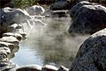
A hot spring near Meager Creek related to volcanism at the massif
