
Meager Creek facts for kids
Quick facts for kids Meager Creek |
|
|---|---|

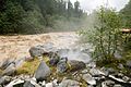
Meager Creek flowing next to a hot spring pool
|
|
| Country | Canada |
| Province | British Columbia |
| Physical characteristics | |
| River mouth | Lillooet River |
Meager Creek is a creek located in the southern Coast Mountains of British Columbia, Canada. It flows northeast and joins the Lillooet River. This meeting point is about 95 kilometers (59 miles) northwest of Pemberton. The creek is also next to the Upper Lillooet Provincial Park.
Meager Creek is famous for its natural hot springs. These hot springs are linked to the Mount Meager massif, a large group of volcanoes nearby.
Contents
Discover Meager Creek Hot Springs
Meager Creek is well-known for its amazing natural hot springs. These warm pools are heated by the same underground volcanic activity that created the Mount Meager massif. This area is very active with volcanoes.
Meager Creek Hot Springs Access
There are two main hot spring areas. The Meager Creek Hot Springs are a bit harder to reach. They require a longer trail of about 9.5 kilometers (5.9 miles).
The Keyhole Hot Springs, also called Pebble Creek Hot Springs, are easier to get to. You can reach them by driving on the Upper Lillooet Forest Service Road. From there, it's only about a 1.5-kilometer (0.9-mile) walk. Always check road reports before you travel!
History of Access and Closures
The hot springs have had some challenges with public access. In 2008, the area reopened after some damage to the site and flooding on the access road. However, in September 2009, a large landslide destroyed the Capricorn Creek Bridge. This closed the springs to the public.
For a while, the only way to reach the springs in winter was by snowmobile or cross-country skiing. You had to travel over the Pemberton Icefield or Meager Glacier. Before 2010, a company called Creekside Resources managed the site and charged a fee to use the pools.
Even though the pools are still officially closed, people can now access the area again. Because access has been limited, regular water quality tests (like for fecal coliform) haven't been done. Before the landslide, these tests were done monthly. The pools often need to be cleaned out before use, which usually takes about 45 minutes.
New Trails and Future Plans
In the summer of 2014, a new public trail opened. It's called the VOC Harrison Hut Trail. Volunteers from the University of British Columbia Varsity Outdoor Club (VOC) built this trail.
In December 2015, the government of British Columbia looked for groups to manage the area. They wanted someone to formally develop the trail that connects to the old Meager Creek Hot Springs Trail. This older trail was built on a decommissioned logging road.
Fees and Camping Rules
Currently, there is no fee to visit the Meager Creek Hot Springs because they are officially closed. If a group is chosen to manage the area, a fee will likely be put in place again. The Lil'wat First Nation's Creekside Resources, who managed the site before, will have the first chance to take over. If they don't, the new manager will maintain the pools. Before 2010, the fee was $5.
Camping in the Valley
While some people camp for free in unofficial spots in the Upper Meager Valley, camping is not allowed right around the hot spring pools. The Meager Creek Hot Springs Recreational Area is a "Minimum Impact Site." This means visitors should leave as little trace as possible.
Also, camping in the very bottom of the valley is not allowed. This is because of significant seismic danger in the area.
Wildlife in the Area
The Meager Creek area is home to many different animals. You might see wolves, wolverines, moose, and various raptors. There are also hybrid black-tailed deer/mule deer and hybrid lynx/bobcats.
Other animals that live here include mountain goats, mountain sheep, and many types of waterfowl. Both grizzly and black bears also live in this region.
Travel and Safety
Getting to Meager Creek usually takes about two hours by car from Pemberton. The journey involves paved roads, gravel roads, and dirt tracks. Most people use four-wheel drive vehicles or large pickup trucks to get there. In winter, the last 25 kilometers (15.5 miles) can be covered by snowmobile.
Natural Hazards
The area around Meager Creek has real and ongoing dangers from avalanches. This is because of the combination of volcanoes and glaciers in the mountains. The Meager Creek valley is one of the most active and dangerous valleys in the North American Cordillera.
Large debris flows, which are like fast-moving landslides of mud and rocks, often come from the Mount Meager massif. These flows have filled the valley to an amazing depth of 250 meters (820 feet).
Images for kids
-
Meager Creek flowing next to a hot spring pool
