Cascadia subduction zone facts for kids
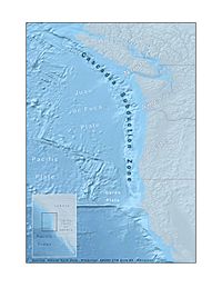
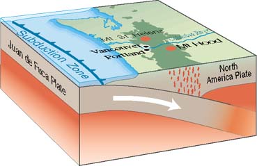
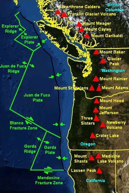
The Cascadia Subduction Zone is a huge underground area where two of Earth's giant plates meet. It stretches from northern Vancouver Island in Canada all the way down to Northern California in the United States. This zone is a very long, sloping area where smaller ocean plates, like the Explorer, Juan de Fuca, and Gorda plates, slowly slide underneath the much larger North American Plate.
This special zone is located offshore, starting near Cape Mendocino in Northern California. It continues along the coasts of Oregon and Washington, and ends near Vancouver Island in British Columbia. The smaller plates are actually pieces of a much older, huge plate called the Farallon Plate. Most of that ancient plate has already slid under North America. The North American Plate itself is also moving slowly, gliding over these smaller plates. It also moves past the giant Pacific Plate in other places, like along the San Andreas Fault in California.
In the Cascadia Subduction Zone, many things happen deep underground. These include plates sticking together and then slipping, deep earthquakes, and active volcanism. This means volcanoes like those in the Cascades can erupt. Famous past eruptions include Mount Mazama (which formed Crater Lake) about 7,500 years ago, and Mount St. Helens in 1980. Big cities like Vancouver and Victoria in British Columbia, Seattle, Washington, and Portland, Oregon, could be affected by a major event in this zone.
Contents
How Scientists Learned About Cascadia
Old Stories and Legends
We don't have written records from the time of the big 1700 Cascadia earthquake. But many First Nations groups in the Olympic Peninsula area have old stories. These legends talk about a huge battle between a thunderbird and a whale. In 2005, a scientist named Ruth Ludwin gathered these stories. Reports from groups like the Huu-ay-aht, Makah, Hoh, Quileute, Yurok, and Duwamish peoples described earthquakes and huge saltwater floods. By studying these stories, researchers could guess when the big event happened, placing it around the year 1701.
Clues from "Ghost Forests"
In 1986, a scientist named Brian Atwater found an important clue. He was digging near Neah Bay and found a layer of marsh soil with plants that had died suddenly. This showed that the ground had quickly sunk below sea level. Saltwater then killed the plants. A layer of sand covered them, keeping them preserved for hundreds of years.
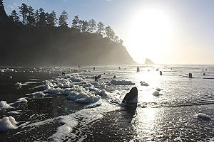
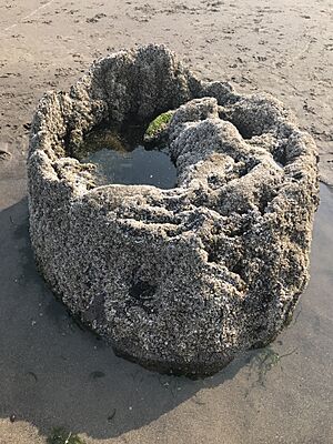
Later, in 1987, Atwater and Dr. David Yamaguchi found a "ghost forest" along the Copalis River. These were dead, gray tree stumps. Scientists first thought the trees died slowly as sea levels rose. But they soon realized the land had dropped quickly, up to two meters, during an earthquake. By studying the tree rings, they found the trees died around the winter of 1699 to 1700. This matched the idea of a sudden event.
Just like the arrowgrass, the riverbanks had a layer of marsh soil covered by sand. Scientists later showed that this sand came from a tsunami wave, not just a storm. In 1995, a team led by Alan Nelson found similar evidence all along the Pacific Northwest coast. This proved that a powerful earthquake had caused the coast to drop. A tsunami then covered it with sand.
The "Orphan Tsunami"
In 1996, another scientist, Kenji Satake, added more evidence. He studied old Japanese records of natural disasters. These records mentioned a 16-foot tsunami that hit Honshu Island in Japan. But there was no earthquake recorded in Japan at that time. So, they called it an "orphan tsunami." By checking the Japanese calendar, Satake found the tsunami happened around midnight on January 27–28, 1700. This meant the huge magnitude 9.0 earthquake in the Pacific Northwest must have happened about ten hours earlier, around 9 PM on January 26, 1700. This confirmed the date of the big Cascadia earthquake.
How the Cascadia Subduction Zone Works
The Cascadia Subduction Zone (CSZ) is a long fault that stretches for about 1,000 kilometers (620 miles). It separates the Juan de Fuca Plate from the North American Plate. New Juan de Fuca plate material is constantly being made offshore.
The Juan de Fuca plate moves towards the continent and slowly slides underneath the North American Plate. This has been happening for about 200 million years. Currently, it slides at a speed of about 40 millimeters (1.6 inches) per year.
At depths shallower than about 30 kilometers (18 miles), the Cascadia zone is "locked." This means the plates are stuck together due to friction. Stress slowly builds up as the plates try to move past each other. Eventually, this stress becomes too much, and the rocks suddenly slip. This causes a very powerful megathrust earthquake. Deeper than 30 kilometers, the plates move more smoothly in what's called "episodic tremor and slip."
The width of the Cascadia subduction zone changes along its length. This depends on how steeply the ocean plate is sliding down. As the plate sinks deeper, it gets hotter and more melted. This means it can't store stress as well. The "locked" zone is where energy is building up for an earthquake. The "transition" zone, which is a bit more flexible, could also break during a quake.
The Cascadia subduction zone connects to other major faults. In the north, near Haida Gwaii, it meets the Queen Charlotte Fault. In the south, off Cape Mendocino in California, it connects to the San Andreas Fault.
Earthquakes in Cascadia Today
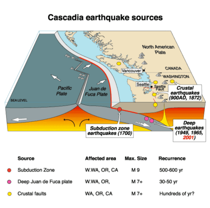
The Cascadia Subduction Zone has different kinds of earthquakes. These include slow earthquakes, megathrust earthquakes, and earthquakes that happen within or between plates. Unlike many other subduction zones around the world, Cascadia doesn't have many big earthquakes very often. The last huge megathrust earthquake was on January 26, 1700.
Even though big quakes are rare, Cascadia still has other types of earthquakes. Scientists use special tools like seismometers to record them.
- Slow Earthquakes: These are very slow movements of the fault. They happen along almost the entire length of Cascadia every 13-16 months. They occur deeper than where the big megathrust earthquakes happen. These movements are so slow that people don't feel them. But scientists can measure them with special GPS tools. The most active areas for these slow tremors are northern Washington, southern Vancouver Island, and northern California.
- Crustal Earthquakes: These earthquakes happen closer to the surface, within the North American Plate. They can cause a lot of damage because they are shallow. A strong magnitude 7 earthquake happened on the Seattle Fault around 900–930 CE. It caused the land to lift by 3 meters and created a 4-5 meter tsunami. Many of these earthquakes also happen in northern California. Oregon has fewer of these types of quakes.
- Intraslab Earthquakes: These earthquakes happen inside the plate that is sliding down. They are most common in northern Cascadia, near Vancouver Island and in Puget Sound. They also happen in southern Cascadia, within the Gorda Plate. The 1949 Olympia earthquake was a damaging magnitude 6.7 intraslab earthquake. It happened at a depth of 52 kilometers and caused 8 deaths. Another important one was the magnitude 6.8 2001 Nisqually earthquake in the Puget Sound area.
Megathrust Earthquakes: The Big Ones
Megathrust earthquakes are the most powerful earthquakes known. They can be stronger than magnitude 9.0. They happen when a lot of energy builds up in the "locked" part of the fault. When the fault finally breaks, it causes a huge earthquake. The longer the fault breaks, the bigger the earthquake. The Cascadia Subduction Zone is a very long fault. This means it can produce very large earthquakes if the entire fault breaks.
Scientists have found that a part of the fault, about 60 kilometers (40 miles) east of where the plates start to deform, is completely locked. This area is storing up a lot of energy. Further east, the plates slide past each other more smoothly.
In 1999, GPS devices showed a small, brief movement of about 2 centimeters (0.8 inches) over a large area. This movement was like a magnitude 6.7 earthquake, but it happened slowly and silently. It didn't cause a sudden quake.
A 2004 study looked at how the land might sink during a Cascadia earthquake. It suggested that towns on the west coast of Vancouver Island, like Tofino and Ucluelet, could suddenly drop by 1–2 meters (3–6 feet) during a quake.
Connection to the San Andreas Fault
Studies show that big earthquakes on the northern San Andreas Fault and the southern Cascadia Subduction Zone might be connected. It seems that quakes on the Cascadia zone might have triggered most of the major quakes on the northern San Andreas over the last 3,000 years. The evidence also shows that these breaks usually moved from north to south. However, the 1906 San Francisco earthquake was different. It was not caused by a major Cascadia quake.
When Will the Next Big One Happen?
The last known huge earthquake in the Pacific Northwest was the 1700 Cascadia earthquake. Scientists believe that very large earthquakes (over magnitude 8.0) have happened at least seven times in the last 3,500 years. This suggests they might happen about every 500 years. However, other evidence from the seafloor shows 41 subduction zone earthquakes in the past 10,000 years. This means the average time between quakes could be closer to 243 years. Out of these 41, 19 caused the entire fault to break. Other similar subduction zones around the world usually have such earthquakes every 100 to 200 years. The longer time between quakes in Cascadia might mean that a lot of stress builds up, leading to unusually large earthquakes.
Scientists also found evidence of tsunamis with every earthquake. The timing of fossil damage from tsunamis in the Pacific Northwest matches historical Japanese records of tsunamis. This is strong proof of these past events.
When the Cascadia Subduction Zone breaks again, it is expected to cause widespread damage across the Pacific Northwest.
Future Predictions
Before the 1980s, scientists thought the Cascadia Subduction Zone wasn't very active. But research by Brian Atwater and Kenji Satake changed that. They connected evidence of a large tsunami on the Washington coast with the "orphan tsunami" in Japan. This showed that the subduction zone was much more dangerous than previously thought.
In 2009, some geologists predicted a 10% to 14% chance that the Cascadia Subduction Zone will produce an earthquake of magnitude 9.0 or higher in the next 50 years. In 2010, other studies suggested the risk could be as high as 37% for earthquakes of magnitude 8.0 or higher.
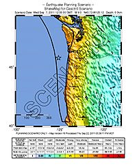
Experts believe the Pacific Northwest region is not fully ready for such a huge earthquake. The next earthquake is expected to be similar to the 2011 Tōhoku earthquake and tsunami in Japan. The break is expected to be as long as the one that caused the 2004 Indian Ocean earthquake and tsunami. The resulting tsunami could reach heights of about 30 meters (100 feet). The FEMA estimates that about 13,000 people could die from such an event. Another 27,000 could be injured. They predict that a million people might lose their homes. Also, 2.5 million people might need food and water.
Cascade Volcanic Arc
The Cascade Volcanic Arc is a chain of volcanoes that stretches from northern California up to the coast of Alaska. These volcanoes are mostly stratovolcanoes, which are cone-shaped mountains built up by many layers of hardened lava and ash. They sit about 100 kilometers (60 miles) inland from the coast. They form a line of peaks that are often over 3,000 meters (10,000 feet) tall.
Some of the major peaks from south to north include:
- Lassen Peak and Mount Shasta (California)
- Crater Lake (Mazama), Three Sisters, Mount Jefferson, Mount Hood (Oregon)
- Mount Adams, Mount St. Helens, Mount Rainier, Glacier Peak, Mount Baker (Washington)
- Mount Garibaldi and Mount Meager massif (British Columbia)
The most active volcanoes in this chain are Mount St. Helens, Mount Baker, Lassen Peak, Mount Shasta, and Mount Hood. Mount St. Helens became famous worldwide when it erupted violently in 1980. St. Helens still rumbles today, with occasional steam plumes and small earthquakes. These are signs that magma is still moving beneath it.
Most of these volcanoes have a main opening where eruptions happen. They are made of layers of hardened lava that can be very explosive.
Here are some of the volcanoes located above the subduction zone:
 | William L. Dawson |
 | W. E. B. Du Bois |
 | Harry Belafonte |


