
Mount Garibaldi facts for kids
Mount Garibaldi is an old, cone-shaped volcano in southwestern British Columbia, Canada. It's about 80 kilometers (50 miles) north of Vancouver. This volcano is part of a chain of volcanoes called the Cascade volcanic arc, which also includes Mount Baker to the south. Mount Garibaldi is actually made up of a few different parts, including Atwell Peak and Dalton Dome. It's located in a volcanic area that has about 13 different vents (places where magma comes out) spread over a large space, much of which is inside Garibaldi Provincial Park.
Contents
How Mount Garibaldi Formed
Mount Garibaldi's history involves two main periods of volcanic activity. The first period happened a very long time ago, between 200,000 and 300,000 years ago. Then, the volcano was quiet for a long time.
About 50,000 years ago, the volcano became active again. During this time, powerful eruptions helped build up the mountain. Imagine fast-moving flows of hot ash, gas, and rock, called pyroclastic flows, rushing down the mountain. These flows built up the volcano, giving it its wide, cone shape.
The Ice Age and Collapse
During the last ice age, thick glaciers filled the valleys around Mount Garibaldi. Part of the volcano's side actually grew on top of this glacial ice in the Squamish River valley. When the ice melted quickly at the end of the ice age, it took away the support from the western side of the volcano. This caused a huge part of the mountain to collapse!
This massive collapse created the rugged, jagged look of Mount Garibaldi and Atwell Peak that we see today. It also left a big scar on the mountain, showing its inside structure, and a huge pile of debris (rock and dirt) at the base of the mountain near Squamish.
Later Eruptions
As the valley glaciers continued to melt away, two lava flows erupted from a place called Clinker Peak, which is just north of Mount Garibaldi. One of these, the Rubble Creek flow, was partly held back by a wall of ice. This made the lava flow incredibly thick, over 244 meters (800 feet) tall! The steep northern edge of this flow has collapsed several times, most recently in 1855-1856. Because of the danger of future collapses, the nearby village of Garibaldi had to be abandoned.
The most recent volcanic activity happened shortly after the glaciers disappeared, between 10,700 and 9,300 years ago. This period ended with the eruption of the Ring Creek lava flow from Opal Cone, located on the southeastern side of Mount Garibaldi.
The Unusual Ring Creek Flow
The Ring Creek lava flow is quite special. It's 15 kilometers (9 miles) long! This is usually the length you'd expect from a different type of lava called basalt, but the Ring Creek flow is made of dacite, which usually doesn't travel as far. This long flow ends only about 6 kilometers (3.7 miles) from the town of Squamish.
Potential Dangers from Mount Garibaldi
Even though Mount Garibaldi hasn't erupted in thousands of years, if it became active again, it could pose a serious threat to nearby communities like Whistler and Squamish.
Ash and Air Travel
While there haven't been super-explosive eruptions (like Plinian-style) known from Mount Garibaldi, even smaller eruptions (like Pelean-type) could produce a lot of ash. This ash could rise hundreds of meters into the sky. Since the volcano is close to Vancouver, this would be dangerous for airplanes flying in and out of the city.
Lava Flows and Mudslides
The danger from lava flows is considered low to moderate. The type of lava from Mount Garibaldi usually doesn't travel very far from its source, even though the Ring Creek flow is quite long.
However, if the remaining glaciers and ice caps on Mount Garibaldi were to melt quickly during an eruption, it could cause floods, lahars (which are like fast-moving mudslides made of volcanic ash and water), or debris flows (fast-moving mixtures of rock, soil, and water). These could endanger smaller communities, including Brackendale.
Impact on Local Areas
Highway 99, which connects Whistler, Squamish, and Vancouver, already experiences landslides and debris flows from the steep Coast Mountains. An eruption causing floods could destroy parts of this important highway. Flooding and debris flows could also seriously affect the salmon fishing in the Squamish, Cheakamus, and Mamquam rivers.
Explosive eruptions and the ash they produce could also cause short-term and long-term problems for Vancouver's water supply and much of the lower mainland. The area that collects water for Greater Vancouver is downwind from Mount Garibaldi. Ash falling on the ice fields east of the volcano could cause them to melt faster, leading to more spring flooding. This, in turn, could threaten water supplies from Pitt Lake and affect fisheries on the Pitt River.
Images for kids
-
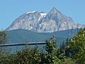
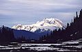
Mount Garibaldi from Squamish
-
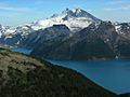
Mount Garibaldi, Mount Price and The Table from The Black Tusk
-
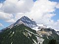
Atwell Peak from the south
-
Mount Garibaldi and The Table
-
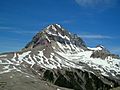
Atwell Peak was the source of pyroclastic flows during Mount Garibaldi's second eruptive stage about 13,000 years ago.
-
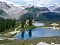
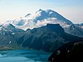
Opal Cone, seen here behind the Elfin Lakes, was the source of an extensive dacitic lava flow late in Mount Garibaldi's eruptive history.
-
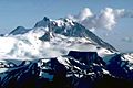
Mount Garibaldi with Mount Price and Clinker Peak in the left-centre
-
Mount Garibaldi as seen from the north-northeast
-
The thunderbird on top of a totem pole in Victoria, British Columbia
-
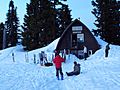
The Elfin shelter
-
Mount Garibaldi and The Table
-
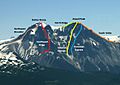
Atwell Peak and Dalton Dome climbing routes


.jpg)


See also
 In Spanish: Monte Garibaldi para niños
