
Mount Jefferson (Oregon) facts for kids
Quick facts for kids Mount Jefferson |
|
|---|---|

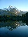
Mount Jefferson from the north side of Three Fingered Jack
|
|
| Highest point | |
| Elevation | 10,502 ft (3,201 m) NAVD 88 |
| Prominence | 5,777 ft (1,761 m) |
| Listing | |
| Geography | |

Mount Jefferson
Location in Oregon
|
|
| Location | Jefferson, Linn and Marion counties, Oregon, U.S. |
| Parent range | Cascade Range |
| Topo map | USGS Mount Jefferson |
| Geology | |
| Age of rock | Less than 100,000 years |
| Mountain type | Stratovolcano |
| Volcanic arc | Cascade Volcanic Arc |
| Last eruption | 950 AD |
| Climbing | |
| First ascent | 1888 by R. L. Farmer and E. C. Cross |
| Easiest route | Rock climb |
Mount Jefferson is a large stratovolcano in the Cascade Range in Oregon, USA. It is the second highest mountain in Oregon. The mountain is found in Linn, Jefferson, and Marion counties. It is also part of the Mount Jefferson Wilderness.
Mount Jefferson is one of the hardest volcanoes to reach in the Cascades because of its rough surroundings. Even so, it is a popular place for tourists. People enjoy hiking, backpacking, mountaineering, and photography there. The area has many trees like Douglas fir and mountain hemlock. Many animals live here, including bears, coyotes, deer, and various birds.
Native Americans called the volcano Seekseekqua. It was later named after U.S. President Thomas Jefferson. The first people to climb it were E. C. Cross and R. L. Farmer in 1888. The volcano formed about 730,000 years ago. It sits where the oceanic Juan de Fuca tectonic plate slides under the North American tectonic plate. This process is called subduction.
Mount Jefferson is made of different kinds of volcanic rock. Glaciers have changed its shape a lot over time. The area around it has other volcanic features like cinder cones and shield volcanoes. Scientists consider Mount Jefferson a low threat for future eruptions. However, they believe mudflows are a major risk.
Contents
Geography

Mount Jefferson is the second tallest mountain in Oregon, after Mount Hood. It is located in the central part of the state. The volcano reaches about 10,497 feet (3,199 m) high. You can often see it from Salem on clear days. It is also visible from highways east and west of the Cascade Range. The land around Jefferson is about 5,500 to 6,500 feet (1,700 to 2,000 m) high. This means the volcano rises almost 1 mile (1.6 km) above its surroundings.
Mount Jefferson Wilderness
Part of Mount Jefferson is in the Warm Springs Indian Reservation. The western part is in the Mount Jefferson Wilderness. This wilderness area is part of the Willamette National Forest and Deschutes National Forests. It covers about 111,177 acres (449.92 km2) and has over 150 lakes. There are also about 190 miles (310 km) of trails, including 40 miles (64 km) of the Pacific Crest National Scenic Trail. Mount Jefferson is the main feature of this wilderness.
Physical Features
Mount Jefferson has a temperate climate. The Cascade Mountains block moisture moving east. This causes warm and dry summers. Winters have more rain and snow, especially at higher elevations. Snowfall can be very heavy at the peak.

When glaciers from the Little Ice Age melted, they left behind lakes. These lakes are common in the Mount Jefferson Wilderness. Some of these lakes have burst in the past. This caused floods and small mudflows. For example, a flood in 1934 buried parts of Jefferson Park under 1 to 8 feet (0.30 to 2.44 m) of debris.
Mount Jefferson has 35 areas of snow and ice. Four of these are named glaciers: Whitewater, Jefferson Park, Russell, and Waldo. These glaciers are mostly on the northern, eastern, and southeastern sides of the mountain. They cover an area of about 5.5 square kilometres (2.1 sq mi). Long ago, during the Ice Age, the volcano was likely covered by a large ice cap. In recent years, the glaciers have been shrinking.
Other features around Jefferson include rocky areas, steep slopes, forests, and meadows. Many rivers flow from Mount Jefferson. These include the South Fork Breitenbush River and the Whitewater River.
Wildfires can happen in the wilderness area. In 2017, the Whitewater fire burned over 10,000 acres (40 km2). This caused trails to close. The Mount Jefferson Wilderness was even closed during the solar eclipse of August 21, 2017.
Plants and Animals
_(desD0002a).jpg)
The plants at Mount Jefferson are mostly conifer trees. These include Douglas fir, silver fir, mountain hemlock, ponderosa pine, lodgepole pine, and different kinds of cedar. Other common plants are vine maple, rhododendron, purple lupine, and red huckleberries. Above the tree line, at about 7,200 feet (2,200 m) high, you will find mountain hemlock and whitebark pine.
Many animals live around Mount Jefferson.
- Meat-eating animals include black bears, coyotes, cougars, red foxes, and bobcats.
- Deer like Roosevelt elk and mule deer are also present.
- Small mammals include American pikas, snowshoe hares, and many types of rodents. These rodents are yellow-bellied marmots, mountain beavers, and different kinds of squirrels.
- Birds are common, such as mallards, red-tailed hawks, great horned owls, and pileated woodpeckers. Other birds include common ravens, American robins, and various sparrows.
- Amphibians and reptiles found here are Long-toed salamanders, western toads, Pacific tree frogs, and common garter snakes.
- About half of the lakes in the area have rainbow trout.
Geology

Mount Jefferson formed less than 730,000 years ago. It was created when the Juan de Fuca tectonic plate slid under the North American tectonic plate. This process is called subduction. The volcano is part of the Oregon High Cascades. The Earth's crust here is about 25 to 28 miles (40 to 45 km) thick.
Mount Jefferson is a stratovolcano. This means it is a cone-shaped volcano built up by many layers of hardened lava, ash, and rock. It is mostly made of basaltic andesite, andesite, and dacite. The volcano is relatively small for a stratovolcano in the Cascades. It has a volume of about 14 cubic kilometres (3.4 cu mi). However, it used to be much larger, perhaps 30 cubic kilometres (7.2 cu mi).
Mount Jefferson has been greatly changed by erosion. Glaciers have worn down the mountain. During the Ice Age, glaciers removed about a third of the volcano's original size. This lowered its height by about 1,000 feet (300 m). Today, glaciers continue to erode the mountain. They are slowly forming a split between the northern and southern parts of the summit.
The main part of the volcano has over 200 layers of andesite lava flows. It also has a very thick dacite lava flow. The upper 3,300 feet (1,000 m) of the cone formed in the last 100,000 years. This part is mostly made of dacite lava flows and lava domes.
Nearby Volcanic Features
Volcanic activity near Mount Jefferson comes from two types of volcanoes. Some are stratovolcanoes, which erupt for thousands of years. Others are monogenetic volcanoes, which erupt only for short times. There are at least 35 volcanic vents within 9 miles (14 km) of Mount Jefferson. These vents have produced lava flows, lava domes, and small shield volcanoes.
The area also has many cinder cone volcanoes. These are cone-shaped hills made of volcanic ash and rock. Some cinder cones south of Mount Jefferson have erupted lava flows. For example, the South Cinder Peak cinder cone erupted about 1,000 years ago. This eruption sent a lava flow that reached Marion Lake.
Eruptive History

Scientists do not have a complete record of Mount Jefferson's eruptions. This is because large glaciers have eroded many of the old deposits. However, they know that the volcano's activity has changed over time. It has produced both powerful explosive eruptions and slower lava flows.
The volcano started forming about 300,000 years ago. Its main cone formed mostly within the last 100,000 years. The most recent activity that built the central cone happened between 30,000 and 20,000 years ago. These eruptions happened during the last Ice Age. This means lava interacted with ice.
About 150,000 years ago, an eruption created volcanic rock in the Park Butte area. A huge explosive eruption happened between 100,000 and 35,000 years ago. This eruption sent ash layers as far as Arco, Idaho. This eruption might have created the volcano's crater. However, later eruptions have filled it in.
The newest lava flows in the Jefferson area are from Forked Butte. These flows happened after Mount Mazama erupted about 7,600 years ago. The very last eruption at Mount Jefferson happened about a thousand years ago. It came from a cinder cone on the side of the South Cinder Peak cone.
Future Activity and Safety
Mount Jefferson is listed as having a "Low/Very Low" threat by the United States Geological Survey. This means it is not expected to erupt soon. However, scientists say it is "almost impossible to estimate the probability of future eruptions." This is because the volcano has not been very active recently.
If Mount Jefferson were to erupt, it could affect the nearby area. Ashfall could reach places far downwind. Lahars (volcanic mudslides) could also travel far from the volcano. The volcano might also produce pyroclastic flows (fast-moving hot gas and rock), lava domes, and lava flows. While not many people live very close to the volcano, over 550,000 people live within 62 miles (100 km) of it.
Lava flows from nearby volcanoes usually move slowly. They would burn and bury anything in their path. Ash from an eruption could be thick enough to cause problems. It could affect air travel and cause breathing issues for some people. Ash can also damage power lines and car engines.
Scientists believe mudflows are the biggest threat at Mount Jefferson. These could happen even without an eruption. For example, if a glacial lake dam breaks, it could cause a mudflow. This has happened in the past. Such mudflows could reach Detroit Lake or Lake Billy Chinook. This would raise lake levels and put people downstream in danger.
Scientists monitor Mount Jefferson for earthquakes. They use special equipment to detect ground movement. So far, there have been no frequent earthquakes in the last 20 years. If earthquake activity increases, scientists are ready to set up more monitoring tools. These tools would check for volcanic gases and ground changes.
Human History
.jpg)
Native Americans called the mountain Seekseekqua. Its English name, Mount Jefferson, honors U.S. President Thomas Jefferson. The Lewis and Clark Expedition named it in 1806. They first saw the peak from the mouth of the Willamette River.
The first people to climb Mount Jefferson were likely E. C. Cross and Ray L. Farmer. They reached the summit on August 12, 1888. They climbed using the south ridge. George J. Pearce, who was with them, wrote about the climb. The first person to climb the north face was S. S. Mohler in 1903.
Recreation

Mount Jefferson is a remote mountain. You can usually only reach it by walking or riding a horse. There are no paved roads within 4 miles (6.4 km) of the mountain. It is not as well-known as some other mountains in Oregon. Still, many hikers, backpackers, and climbers visit the mountain each year. Most visitors come during the summer.
The Warm Springs Tribal Council does not allow public access to the eastern side of the volcano. So, people can only use the western side. You can reach the western side from the Oregon Route 22 highway.
Jefferson Park is on the northern slope of the mountain. You can hike to it by taking the Whitewater Trail. Then, follow the Pacific Crest Trail for 1 mile (1.6 km). Jefferson Park is a popular spot for its views, lakes, and meadows. People enjoy backpacking, climbing, and hiking there. It is also great for nature photography. The area has 26 campsites. These campsites have rules, like a maximum group size of 12 people. Campfires are not allowed.
The Jefferson Lake Trail is 4.2 miles (6.8 km) long round trip. It has an elevation gain of 400 feet (120 m). Parts of this trail were damaged by a fire in 2003. However, the trail has reopened after repairs.
At Marion Lake, there are several trails. One route is 6 miles (9.7 km) long. Another hike to Marion Mountain is 11.2 miles (18.0 km) round-trip. These trails offer views of areas affected by past wildfires.
The Whitewater Trail goes north through the wilderness for 1.5 miles (2.4 km). It then reaches a junction. The right path leads 2.5 miles (4.0 km) to the Pacific Crest Trail. In the Maxwell trail area, you can find hikes for all skill levels. These include the challenging Maxwell Butte Trail and the 9-mile (14 km) Santiam Lake Trail.
The Pamelia Lake trail area has streams, lakes, and springs. It also has bathrooms, parking, and picnic tables. To protect the wilderness, only 20 groups are allowed per day in the Pamelia Limited Entry Area. Group sizes are also limited. Trails at Pamelia Lake include the Hunts Creek Trail and a part of the Pacific Crest Trail. The Pamelia Lake Trail rises 800 feet (240 m) before meeting the Hunts Creek Trail. This area is popular for backpacking, mountaineering, horseback riding, and day hiking.
Other popular trails include the Firecamp Lakes Trail and Canyon Creek Meadows trails. Some of the most visited areas around Mount Jefferson Wilderness are Eight Lakes Basin, Pamelia Lake, Jack Lake, Duffy Lake, Russell Lake, Santiam Lake and Wasco Lake.
Climbing Mount Jefferson is very challenging. The summit is especially difficult. Sadly, almost every year, at least one climber has a serious accident while trying to climb Jefferson. Because of the dangers, the U.S. National Geodetic Survey suggests that only very experienced climbers attempt it.
Images for kids
-
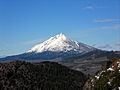
Mount Jefferson from the north side of Three Fingered Jack
-
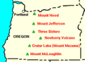
Jefferson's location in Oregon relative to other major volcanoes
-
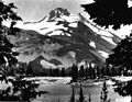
A view of Mount Jefferson from Russell Lake in 1934
-
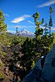
A coniferous forest near Mount Jefferson (Jefferson visible in the background)
-
Mount Jefferson
-
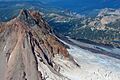
An aerial photo of the summit of Mt. Jefferson, October 2015
-
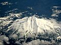
Mount Jefferson from above
-

Mount Jefferson was named after the third President of the United States, Thomas Jefferson (pictured; painted in 1800 by Rembrandt Peale)
-
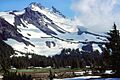
Mount Jefferson from the Mount Jefferson Wilderness area

