
Warm Springs Indian Reservation facts for kids
Quick facts for kids
Warm Springs Indian Reservation
|
|
|---|---|

Location of the Warm Springs Indian Reservation and former tribal area
|
|
| Tribe | Confederated Tribes of Warm Springs |
| Country | United States |
| State | Oregon |
| Area | |
| • Total | 2,640 km2 (1,019 sq mi) |

The Warm Springs Indian Reservation is a large area of land in central Oregon, USA. It covers about 1,019 square miles (2,639 square kilometers). This land is managed by the Confederated Tribes of Warm Springs.
Contents
Meet the Tribes of Warm Springs

The Warm Springs Reservation is home to three main tribes. These are the Wasco, Tenino (also known as Warm Springs), and Paiute people. Since 1938, these tribes have worked together. They are now known as the Confederated Tribes of Warm Springs.
A Look at Warm Springs History
The Warm Springs Reservation was created by a special agreement called a treaty in 1855. This treaty set the exact borders of the land. It was a very important agreement for the tribes.
The Warm Springs and Wasco tribes gave up a huge area of land. This land was about 10 million acres (40,000 square kilometers). They had lived there for over 10,000 years. In return, the treaty promised them healthcare, education, and other help. This was all part of the Treaty with the Tribes of Middle Oregon.
The treaty also made sure that tribal members could still hunt and fish. They kept these rights in their old hunting and fishing areas. These were not new rights given by the U.S. government. They were rights the tribes already had and kept.
Paiute People Join the Reservation
In the late 1800s, the U.S. government moved some Paiute people to the reservation. About 38 Paiutes moved there in 1879. Then, around 70 more moved in 1884. This happened even though the Paiute tribe had a history of disagreements with the other tribes.
The McQuinn Strip Land Dispute
The exact borders of the reservation were argued about for 101 years. This argument was called the McQuinn Strip boundary dispute. In 1871, a surveyor named T.B. Handley measured the land. He said it was smaller than what the 1855 treaty described.
The Warm Springs people disagreed with Handley's measurement. In 1887, another surveyor, John A. McQuinn, agreed with them. He found that Handley had measured the land incorrectly. By this time, other people had moved onto the disputed land. The government offered money to the Warm Springs people for the land. But the Warm Springs people said no. Finally, in 1972, a new law gave the land back to the Warm Springs people.
Where is Warm Springs Located?

The reservation is mostly in Wasco County and Jefferson County. But it also has smaller parts in six other counties. These include Clackamas, Marion, and Hood River counties.
The reservation is about 105 miles (169 kilometers) southeast of Portland. More than half of the land, about 348,000 acres (1,408 square kilometers), is covered in forests.
Warm Springs Population and People
In the year 2000, about 3,314 people lived on the reservation. The main town on the reservation is called Warm Springs. This town is home to over 73% of all the people living on the reservation. By 2003, more than 4,200 tribal members were officially enrolled.
Culture and Languages of Warm Springs
The Warm Springs Reservation is one of the few places where Chinook Jargon is still spoken. This language was useful for different tribes to talk to each other. The way elders speak it here is different from other places.
Schools on the Warm Springs Reservation teach tribal languages. These include Kiksht, Numu, and Ichishkiin Snwit. This helps keep the languages alive.
The Museum at Warm Springs has many old items from North American Indian cultures. It opened in 1993. It helps people learn about the history and traditions of the tribes.
How the Warm Springs Economy Works
The tribes earn most of their money from hydroelectric projects. These projects use the power of the Deschutes River to make electricity. This business is called Warm Springs Power Enterprises. The tribes also run Warm Springs Forest Products Industries. This company works with wood from the forests.
Many tribal members also fish in the Columbia River. They catch salmon, steelhead, and sturgeon. They fish for food, for special ceremonies, and to sell. They also fish for salmon and steelhead in the Deschutes River, especially at Sherars Falls. Tribal members also gather Pacific lamprey at Sherars Falls and Willamette Falls. The tribes' fishing rights are protected by their treaty. Court cases like Sohappy v. Smith and United States v. Oregon have also confirmed these rights.
Fun and Tourism at Warm Springs

In 1964, the first part of the Kah-nee-ta resort was finished. It had a motel, small cabins, and tipis for people to stay in. Later, the resort grew to include a lodge, a casino, a convention center, and a golf course. However, the resort closed in September 2018 because it was not making enough money.
The Indian Head Casino opened in February 2012. It is located on U.S. Route 26. The casino has 18,000 square feet (1,672 square meters) of gaming space. It has 500 slot machines and 8 blackjack tables. The tribes hoped the casino would make $9 to $12 million each year. The casino used to be at Kah-Nee-Ta. There, it only had 300 slot machines and made less money. The new location is easier for travelers to reach.
Other Businesses and Ventures
In 2016, the tribe's lumber mill closed down. It was also located near the village of Warm Springs. The mill had been working for many decades. But its production had gone down in recent years. In 2016, the tribe also gained the right to certify drone operators. This right was given by the Federal Aviation Administration.
Wildlife and Nature at Warm Springs
Biologists from the Confederated Tribes of Warm Springs help track wolves in Oregon. They work with the Oregon Department of Fish and Wildlife. Wolves are now moving into areas where they have not lived for many years. This includes the northern Cascade Mountains.
In June 2020, biologists put a special collar on a male wolf named OR-93. This wolf left his pack and traveled far. In February 2021, he became the 16th gray wolf found in repopulation of wolves in California. He reached Mono County, near Yosemite National Park. In December 2021, two adult wolves were found on the reservation by biologists. Then, in August 2022, two wolf pups were seen on a trail camera. These new wolves mean there are now three known wolf groups in the area.
Warm Springs Infrastructure
Water for the reservation comes from the Deschutes River. It goes through a special treatment facility. This clean water then serves about 3,800 people on the reservation.
Images for kids
-
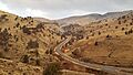
View of a road in the Warm Springs Reservation
-
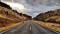
Road to the now closed Kah-Nee-Ta Resort
-
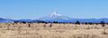
Mount Hood (as seen from Warm Springs Reservation)
-
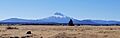
Mount Jefferson (as seen from Warm Springs Reservation)


