
Willamette Falls facts for kids
Quick facts for kids Willamette Falls |
|
|---|---|
 |
|
| Lua error in Module:Infobox_mapframe at line 185: attempt to index field 'wikibase' (a nil value). | |
| Location | Oregon City / West Linn, Clackamas County, Oregon, U.S. |
| Coordinates | 45°21′09″N 122°37′03″W / 45.35239°N 122.61763°W |
| Type | block |
| Total height | 40 ft (12 m) |
| Number of drops | 1 |
| Average flow rate |
30,849 cu ft/s (874 m3/s) |
The Willamette Falls is a natural waterfall located on the Willamette River in the United States. It sits between the cities of Oregon City and West Linn, Oregon. This amazing waterfall is the largest in the Northwestern United States when you measure its water volume. It is also the seventeenth widest waterfall in the world!
The falls are shaped like a horseshoe. They are about 1,500 feet (457 meters) wide and 40 feet (12 meters) high. A huge amount of water, about 30,849 cubic feet (874 cubic meters) per second, flows over them. The Willamette Falls are located about 26 miles (42 kilometers) upriver from where the Willamette River meets another river. Until 2011, a special canal and a set of locks helped boats pass the falls. However, these locks are now closed.
Contents
History of Willamette Falls

Native American stories say that a great god put the falls there. This was so their people would always have fish to eat, especially during winter. The Willamette Falls area was once home to the Charcowah village. These were people from the Clowewalla band of Tumwaters, who spoke a language called Upper Chinookan.
The Native American lands here were given to the United States Government in 1855. This happened through the Willamette Valley Treaty. After this, tribal members had to move from their old lands to the Grand Ronde Reservation. This reservation was a large area of 60,000 acres.
.JPG)
Willamette Falls was a very important place for many Native American tribes. Lots of salmon lived there, which brought tribal members from all over. They came to fish, trade, and meet up at the falls. This made the area a busy center for business. Even though Native Americans were moved away, the falls are still important today. Each year, the Grand Ronde Tribe catches special salmon for ceremonies. They also collect lamprey fish in the summer. Other tribes, like the Warm Springs, also collect Pacific Lamprey at the falls.
European fur traders first learned about the falls in 1810. John McLoughlin claimed land at the falls for the Hudson's Bay Company in 1829. The city of Oregon City was started in 1842 near the east side of the falls. Another town, Linn City, was founded on the west side in 1843. These two towns competed to get the most business from steamboats. Steamboat captains had to choose which side of the river to dock on. This led to a lot of competition between the towns.
The competition ended with the Great Flood of 1862. Oregon City was badly damaged by the flood. But Linn City was completely wiped out. Boats could not get past the falls until the Willamette Falls Locks were finished in 1873. During the building of the locks, parts of the rocks where Linn City once stood were blasted away. Today, the modern city of West Linn sits on some of the old Linn City site. The locks were later sold to the United States Army Corps of Engineers in 1915.

Modern History of the Falls
The Willamette Falls Electric Company was started in 1888. This company, later called Portland General Electric, built a power plant at the falls. This plant used the force of the water to create electricity. Four machines called turbine-driven dynamos were built on the east side of the falls. In 1889, a 14-mile (23-kilometer) long power line was built to Portland. This was the first long-distance transmission of electrical energy in the United States.
In 1895, Portland General Electric built a second power station on the west side. This newer plant is now called the T. W. Sullivan Hydroelectric Plant. It is still working today and can produce 16,000 kilowatts of power. You can still see the foundations of the older plant.
Several paper mills have been located at the falls. The first one, the Oregon City Paper Manufacturing Co., opened in 1866. The Willamette Pulp and Paper Co. opened on the West Linn side in 1889. The ownership of these mills changed many times over the years. In 2011, the last two mills were the West Linn Paper Company and the Blue Heron Paper Company. The West Linn Paper Company closed in 2017 but reopened in 2019 as Willamette Falls Paper Company. The Blue Heron Paper Company closed its mill in 2011.
The land where the Blue Heron mill was located has been sold for new development. An investment company bought the old mill buildings. They started removing old machines and cleaning up the land. In 2019, the Confederated Tribes of Grand Ronde bought the property.
The many factories in the area caused fewer salmon and steelhead fish to return to the river. Because of this, a special fish ladder was built in 1882. A newer fish ladder, built in 1971, is still used today. It is managed by the Oregon Department of Fish and Wildlife. For example, about 52,000 spring chinook salmon returned in 2007. For a long time, people could not get close to the bottom of the waterfall because of the factories. But now, plans are being made to build a public walkway and allow people to visit the area.
Willamette Falls Details
The Willamette Falls is a horseshoe-shaped waterfall. It is formed by a hard rock layer called basalt on the river floor. The falls are 40 feet (12 meters) high and 1,500 feet (457 meters) wide. They are located 26 river miles (42 kilometers) upstream from where the Willamette River joins the Columbia River. The locks at the falls were managed by the U.S. Army Corps of Engineers. They were a four-lock canal system. This system was the oldest continuously working navigation canal in the United States.
You can see the falls from several places. There are viewpoints on the hills in Oregon City. You can also see them from a marked spot along Highway 99E. The Oregon City Bridge also offers a good view. Another viewpoint is on northbound I-205. You can also see the falls from boats on the river.
Images for kids
-
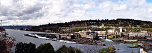
Panorama of the paper mill on October 23, 2010
-
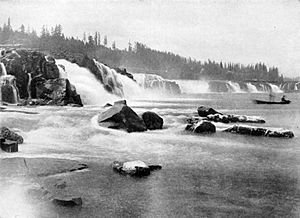
The falls in 1918
-
The falls after the Hanukkah Eve windstorm of 2006 swelled the Willamette River and part of the paper mill
-
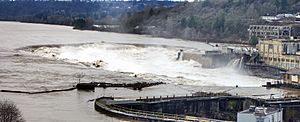
An aerial view of the Willamette Falls with the river near flood stage, taken on January 22, 2006
-
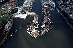
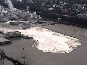
View is downriver facing northeast. The locks are at far left.
-
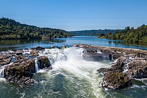
Willamette Falls as seen from overhead via a drone on July 19, 2017


