
Willamette River facts for kids
Quick facts for kids Willamette River |
|
|---|---|

The Willamette passing through Downtown Portland in the 1980s
|
|

A map of the Willamette River, its drainage basin, major tributaries and major cities
|
|
| Country | United States |
| State | Oregon |
| Cities | Eugene, Corvallis, Albany, Independence, Salem, Newberg, Wilsonville, Portland |
| Physical characteristics | |
| Main source | Confluence of Middle Fork Willamette River and Coast Fork Willamette River near Eugene, Lane County, Oregon 438 ft (134 m) 44°01′23″N 123°01′25″W / 44.02306°N 123.02361°W |
| River mouth | Columbia River Portland, Multnomah County, Oregon 10 ft (3.0 m) 45°39′10″N 122°45′53″W / 45.65278°N 122.76472°W |
| Length | 187 mi (301 km) |
| Basin features | |
| Basin size | 11,478 sq mi (29,730 km2) |
| Tributaries | |
The Willamette River ( wil-AM-it) is a major river in Oregon, United States. It flows into the Columbia River, providing about 12 to 15 percent of the Columbia's water. The Willamette is 187 miles (301 km) long and runs entirely within northwestern Oregon.
It flows north between the Oregon Coast Range and the Cascade Range. The river and its smaller streams form the Willamette Valley. This valley is home to two-thirds of Oregon's population. This includes Salem, the state capital, and Portland, Oregon's largest city. Portland is located where the Willamette meets the Columbia River.
The Willamette River basin was formed by plate tectonics about 35 million years ago. It was later changed by volcanoes and erosion. Huge floods, called the Missoula Floods, shaped the river's area at the end of the last ice age. People have lived in this area for over 10,000 years. Many Native American villages once existed along the lower river and near its mouth.
The Willamette Valley has very rich soil from floods and lots of rain from the Cascades. This makes it one of the best farming areas in North America. Many pioneers traveled here in the 1800s using the Oregon Trail. The river was important for travel in the 19th century. However, Willamette Falls, near Portland, was a big obstacle for boats. Today, major highways follow the river, and about 30 bridges cross it. There are also ferries that carry cars and people across the river.
Since 1900, more than 15 large dams have been built in the Willamette's area. The U.S. Army Corps of Engineers (USACE) runs 13 of these dams. These dams help produce hydroelectricity (power from water), create lakes for fun, and prevent floods. The river and its smaller streams are home to 60 types of fish, including many salmon and trout. This is true even with the dams and pollution, especially in the lower parts of the river. Part of the Willamette Floodplain became a National Natural Landmark in 1987. The river was also named one of 14 American Heritage Rivers in 1998.
Contents
- Willamette River's Path
- How the Willamette Valley Was Formed
- Willamette River Watershed
- Willamette River History
- Dams and River Control
- Bridges Over the Willamette
- Flooding in the Willamette Valley
- River Pollution and Cleanup Efforts
- Plants and Animals of the Willamette River
- Images for kids
- See also
Willamette River's Path

The Willamette River starts from smaller streams in the mountains south of Eugene, Oregon. It forms where the Middle Fork Willamette River and the Coast Fork Willamette River meet near Springfield. From there, the main river flows generally north for 187 miles (301 km) until it reaches the Columbia River.
The river makes two big turns. One is at Newberg, where it turns sharply east. About 18 miles (29 km) downstream, it turns north again. Near its mouth, north of downtown Portland, the river splits into two paths around Sauvie Island. These paths are managed by the U.S. federal government for boats.
The main path is 40 feet (12 m) deep and 600 to 1,900 feet (180 to 580 m) wide. It is the main route for ships going to Portland's harbor. This path joins the Columbia River about 101 miles (163 km) from the Pacific Ocean. The smaller path, called the Multnomah Channel, is 21 miles (34 km) long, about 600 feet (180 m) wide, and 40 feet (12 m) deep. It ends about 14.5 miles (23.3 km) farther downstream on the Columbia, near St. Helens.
Between the 1850s and 1960s, projects to straighten the river and control floods shortened parts of it. For example, the river between the McKenzie River and Harrisburg was cut by 65 percent.
_(mulDA0081a).jpg)
Interstate 5 and three parts of Oregon Route 99 are the main highways that follow the river. Towns along the river include Springfield, Eugene, Corvallis, Albany, Salem, and Portland. Important smaller rivers that flow into the Willamette include the McKenzie, Long Tom, Marys, Santiam, and Clackamas rivers.
The Willamette River starts at 438 feet (134 m) above sea level. It drops 428 feet (130 m) by the time it reaches its mouth. This means it drops about 2.3 feet per mile (0.4 m per km). At Willamette Falls, the river drops about 40 feet (12 m). After the falls, the river is very flat. It is even affected by the ocean's tides from the Columbia River. The main part of the Willamette is about 330 to 660 feet (100 to 200 m) wide.
River Flow and Discharge
The Willamette River is the 19th largest river in the United States by water volume. It adds 12 to 15 percent of the total water to the Columbia River. The amount of water in the Willamette changes a lot throughout the year. It averages about 8,200 cubic feet per second (230 m3/s) in August. This increases to more than 79,000 cubic feet per second (2,200 m3/s) in December.

The U.S. Geological Survey (USGS) has five stations that measure the river's flow. These are located at Harrisburg, Corvallis, Albany, Salem, and Portland. Near the Morrison Bridge in Portland, the average flow was 33,220 cubic feet per second (941 m3/s) between 1972 and 2013. This station measures water from about 97 percent of the Willamette basin.
The highest flow recorded at this station was 420,000 cubic feet per second (11,893 m3/s) on February 9, 1996, during a big flood. The lowest flow was 4,200 cubic feet per second (120 m3/s) on July 10, 1978. An even higher flow of 635,000 cubic feet per second (18,000 m3/s) was recorded in Portland during a flood in 1861. Many large floods happened before dams were built to control the river.
The river below Willamette Falls is affected by the ocean's tides. Sometimes, the water even flows backward below Ross Island.
How the Willamette Valley Was Formed
The Willamette River basin was mainly created by plate tectonics (the movement of Earth's large plates) and volcanism (volcanic activity). It was also shaped by erosion and sediments, including deposits from huge glacial floods about 13,000 years ago.
The oldest rocks under the Willamette Valley are called the Siletz River Volcanics. About 35 million years ago, these rocks were pushed under another plate. This created a basin that later became the Willamette Valley. This valley was first part of the ocean floor. Many layers of ocean deposits formed here. About 20 to 16 million years ago, the Coast Range mountains rose up. This separated the basin from the Pacific Ocean.
About 15 million years ago, Basalt lava from volcanoes in eastern Oregon flowed across much of the northern part of the basin. This lava covered areas like the Tualatin Mountains with up to 1,000 feet (300 m) of lava. Later, silt up to 1,000 feet (300 m) thick covered the basalt. During the Ice Age, starting about 2.5 million years ago, volcanoes in the Cascades and a cool, wet climate caused more sediment to build up.

Between 15,500 and 13,000 years ago, the Missoula Floods happened. These were huge floods from a glacial lake in Montana. They rushed down the Columbia River and filled the Willamette Valley. Each flood was so big that it carried more water than all the world's rivers today combined.
These floods filled the Willamette basin up to 400 feet (120 m) deep in the Portland area. They created a temporary lake called Lake Allison, which stretched from Lake Oswego to near Eugene. The floods left behind layers of silt and clay, forming the rich valley floor we see today. The floods also carried icebergs from Montana into the valley. When these icebergs melted, they dropped large rocks called glacial erratics. These rocks are made of materials not found in the Willamette Valley. The largest of these rocks originally weighed about 160 short tons (150 t).
The northern part of the watershed has many faults that can cause earthquakes. Many small earthquakes have happened here since the mid-1800s. In 1993, the Scotts Mills earthquake was the largest recent quake in the valley. It measured 5.6 on the Richter scale and caused $30 million in damage.
Scientists believe that very strong earthquakes (8 or more on the Richter scale) have happened off the Oregon coast. The most recent was in 1700 CE. Even stronger quakes (up to 9 on the Richter scale) might happen every 500 to 800 years. Because many people live in the Willamette Valley and its soil can make shaking worse, the area is at high risk from strong earthquakes.
Willamette River Watershed

The Willamette River drains an area of 11,478 square miles (29,730 km2). This is 12 percent of Oregon's total land area. The river basin is about 180 miles (290 km) long and 100 miles (160 km) wide. It is bordered by the Coast Range to the west and the Cascade Range to the east. The highest point in the watershed is Mount Jefferson at 10,495 feet (3,199 m). The lowest point is the river's mouth at 10 feet (3.0 m) above sea level.
About 2.5 million people lived in the Willamette River basin in 2010. This is about 65 percent of Oregon's population. In 2009, 20 of Oregon's 25 largest cities were in this basin. These cities include Portland, Eugene, Salem, and Corvallis. Not all of these cities get their drinking water from the Willamette River.
Most of the watershed (64 percent) is privately owned. The rest (36 percent) is public land. The U.S. Forest Service manages 30 percent of the watershed. About 68 percent of the watershed is covered by forests. Farming takes up 19 percent, mostly in the Willamette Valley. Urban areas (cities and towns) cover 5 percent. There are over 81,000 miles (130,000 km) of roads in the watershed.
In 1987, a part of the watershed in Benton County was named a National Natural Landmark. This area is the Willamette Floodplain. It is the largest remaining natural grassland in the North Pacific region.
Willamette River History
First People of the Valley

For at least 10,000 years, different groups of Native Americans lived in the Willamette Valley. These included the Kalapuya, the Chinook, and the Clackamas. The Clackamas lived in the northeastern part of the basin, sharing their name with the Clackamas River. The Chinook once lived across the northern part of the watershed and the Columbia River valley.
Native American groups in the Willamette Valley included the Kalapuya-speaking Yamhill and Atfalati (Tualatin). Other groups were the Santiam, Muddy Creek, Long Tom, Calapooia, Marys River, and Luckiamute. The name Willamette comes from a Clackamas Native American village name. It might also come from similar Kalapuya dialects.

Around 1850, there were an estimated 2,000 to 3,000 Kalapuya people. The Clackamas tribe had about 1,800 people. The Chinook population was nearly 5,000, though not all lived on the Willamette. The total Native American population was estimated at 15,000.
The Native Americans of the Willamette River had different ways of life. Those closer to the coast often relied on fishing, especially for Salmon. Tribes further upriver caught steelhead and salmon. They often built weirs (fish traps) across smaller streams.
Tribes in the northern Willamette Valley lived in settled communities. The Chinooks lived in large wooden lodges. They had a clear social system. People in the south moved from place to place with the seasons. They were known for burning woodlands to create open areas for hunting and gathering plants like camas.
Early European Explorers and Settlers
The Willamette River was first written about in 1792 by British Lieutenant William Robert Broughton. He was part of the Vancouver Expedition.
In 1805-1806, the Lewis and Clark Expedition missed the mouth of the Willamette at first. On their way back, Native Americans told them about it. William Clark explored the Willamette River in April 1806.
Fur trappers from the Pacific Fur Company and later the North West Company were the next to visit. The Siskiyou Trail, an old Native American path, was used to travel south. This trail stretched from the Willamette River's mouth to San Francisco.
In 1812, trappers reached the falls (now Oregon City). A trading post was set up. By 1813, another outpost, Wallace House, was established north of Salem. Native American tribes warned the trappers to stay out of their hunting grounds.
By 1829, French Canadian settlers began to claim land and settle in the Willamette Valley. By 1843, about 100 new families lived in the area known as French Prairie.
In 1841, the United States Exploring Expedition noted that Native Americans did a lot of salmon fishing at Willamette Falls.
The Oregon Trail and Growth
In the mid-1800s, the rich soil, good climate, and plenty of water in the Willamette Valley attracted thousands of settlers. Most came from the eastern United States. Many followed the Oregon Trail, a 2,170-mile (3,490 km) path that ended near the Willamette River. Large-scale migration began in 1843, with nearly 1,000 pioneers. Over the next 25 years, about 500,000 settlers traveled the Oregon Trail to reach the Willamette Valley.

Starting in the 1830s, Oregon City grew near Willamette Falls. It became the first city west of the Rocky Mountains in 1844. John McLoughlin, a leader from the Hudson's Bay Company, helped found the town. Oregon City thrived because of mills powered by the falls. However, the falls blocked river travel.
After Portland became a city in 1851 and grew quickly, Oregon City became less important. In the 1850s, steamboats began to use the Willamette. Since they couldn't pass the falls, boats had to be carried around them. In 1873, the Willamette Falls Locks were built. These locks allowed boats to pass the falls easily. Use of the locks was highest in the 1940s, but by the 2000s, they were rarely used. Since 2011, the locks have been closed.
As businesses grew, settlers took over more Native American lands. Conflicts led to the forced removal of Native Americans. They were moved to the Grande Ronde Reservation.
Between 1879 and 1885, Cleveland S. Rockwell mapped the Willamette River in great detail. His work helped open the port of Portland for trade. The USACE also dredged channels and built locks and levees. These improvements helped businesses transport goods to Portland.
Modern Times and River Care

By the early 1900s, big projects began to control the river. Levees were built along the river in most cities. Portland built concrete walls to protect its downtown. Later, many large dams were built on the Willamette's smaller rivers in the Cascade Range. The Army Corps of Engineers runs 13 of these dams. Most of them do not have ways for fish to pass.
As cities grew, so did pollution in the river. By the late 1930s, efforts began to clean it up. In the 1960s, Oregon Governor Tom McCall pushed for stronger pollution controls. The Oregon State Legislature started the Willamette Greenway program in 1967. This program created parks, trails, and wildlife areas along the river. In 1998, the Willamette was named an American Heritage River. By 2007, the Greenway included over 170 public areas for camping, swimming, fishing, and hiking.
In 2008, the Willamette River was named the Willamette River Water Trail. In 2012, it became a National Water Trail. This system helps protect waterways and improve outdoor fun.
In 1991, Portland started the Big Pipe Project. This project aimed to stop raw sewage from flowing into the river during heavy rains. The project was finished in 2011. It has reduced sewage overflow into the lower river by about 94 percent.
In 2014, Dean Hall became the first person to swim the entire 184 miles (296 km) length of the Willamette River. He swam from Eugene to the river mouth in 25 days. In 2017, Portland opened its first official public swimming beach, Poet's Beach.
Dams and River Control

There are over 20 major dams on the Willamette's smaller rivers. There are also many levees and channels to control the river's flow.
The only dam on the main Willamette River is the Willamette Falls Dam. This low dam helps direct water to nearby mills and a power plant. The Willamette Falls Locks were completed in 1873 to help boats pass the falls. Other smaller structures on the main river make the channel narrower and deeper for boats and flood control.
The dams on the Willamette's major tributaries are large. They are mainly used to control floods, store water, and generate power. The United States Army Corps of Engineers (USACE) built 13 of these dams between the 1940s and 1960s. Nine of them produce hydroelectricity. These dams can hold up to 27 percent of the Willamette's runoff. They help reduce flood peaks and increase water flow in late summer. Only a small amount of stored water is used for farming.

Cougar Dam and Detroit Dam are the two tallest dams in the Willamette River basin. Detroit Dam is 463 feet (141 m) high. Lookout Point Dam has the largest water storage capacity.
These tall dams block Chinook salmon and steelhead from about half of their natural spawning areas. This has pushed them close to extinction. A lawsuit in 2008 led to a plan to help fish pass the dams and recover. However, progress has been slow due to engineering challenges and costs.
Other major dams in the Willamette watershed are owned by different groups. For example, Portland General Electric owns several power plants on the Clackamas River.
Bridges Over the Willamette

There are about 50 bridges that cross the Willamette River. Many are historic. The Van Buren Street Bridge, built in 1913, is a swing bridge. It carries Oregon Route 34 in Corvallis. The Oregon City Bridge, built in 1922, crosses the river between Oregon City and West Linn.
The Ross Island Bridge carries U.S. Route 26 in Portland. It is one of 10 highway bridges in Portland. This 3,700-foot (1,100 m) bridge is the only cantilevered deck truss in Oregon.

Tilikum Crossing is a 1,720-foot (520 m) cable-stayed bridge. It carries public transit, bikes, and pedestrians, but no cars. It opened in 2015.
The Hawthorne Bridge, built in 1910, is the oldest highway bridge still standing over the Willamette. It is the oldest vertical-lift bridge in the U.S. It is also the busiest bridge in Oregon for bikes and public transit.

The Steel Bridge, built in 1912, was once the world's largest telescoping bridge. It carries trains on its lower deck and light-rail trains and cars on its upper deck. It also has a walkway for people and bikes. Its unique design allows the lower deck to be raised without moving the upper deck. Both decks can be raised up to 163 feet (50 m) above the water.
The Broadway Bridge, built in 1913, was the world's longest double-leaf bascule (drawbridge) at the time. Further downstream, the St. Johns Bridge, a steel suspension bridge built in 1931, replaced the last ferry in Portland. It carries the U.S. Route 30 Bypass. The bridge has two Gothic-style towers. It is the tallest bridge in Portland, with 400-foot (120 m) tall towers.

Flooding in the Willamette Valley

The Willamette River often floods because of heavy rain and melting snow in western Oregon. The biggest flood in recorded history happened in 1861, before any dams were built.
In December 1861, heavy rains and warm temperatures melted a lot of snow in the Cascades. This caused the largest Willamette River flood ever recorded. One person wrote that "The whole Willamette valley was a sheet of water." Thousands of acres of farmland were washed away. Many towns were damaged or destroyed. This "Great Flood" was very destructive because most towns were built on the river's floodplain. The 1861 flood covered about 353,000 acres (1,430 km2) of land. It destroyed the town of Linn City. Today, West Linn stands where Linn City once was.
Big floods also happened in 1890 and 1894. In 1890, Portland's main street was underwater. Communication was cut off, and many train lines closed.

Throughout the 1940s, the Willamette continued to flood. In December 1942, five bridges in Lane County were washed out. In May 1948, it helped destroy Vanport City and caused about 15 deaths.
Even with many dams and controls, the Willamette still had severe floods. A major flood happened from December 1964 to January 1965. It covered nearly 153,000 acres (620 km2) of land. On December 21, 1964, the Willamette reached 29.4 feet (9.0 m) in Portland, higher than the seawall. About 15 people died, and 8,000 had to leave their homes.
The river crested at one town after another—at Corvallis 3½ feet above flood stage, Oregon City 18 feet above, Portland 10.5 feet above—much like a meal moving through a boa constrictor.
In February 1996, heavy warm rains fell on deep snow. This caused some of the most expensive flooding in the river's history. An Associated Press reporter said the river "crested at one town after another... much like a meal moving through a boa constrictor." The flood caused serious problems for Oregon's economy. About 117,000 acres (470 km2) of land was flooded.
After the 1996 flood, concrete walls in Portland were replaced with stronger steel walls. These new walls were designed to prevent future flooding.
River Pollution and Cleanup Efforts

Since the late 1800s, human activity has changed the river's environment. Waste from cities made the main river "an open sewer by the 1920s." Dams built between 1941 and 1969 damaged areas where Chinook salmon and steelhead laid their eggs.
In 1927, a report called the river "filthy and ugly." It said Portland was the worst polluter. In 1938, a public vote led to a law to reduce pollution.
Governor Tom McCall, elected in 1966, ordered water quality tests. He found the river was very polluted in Portland. He worked to make it harder for companies to pollute the river. He also closed plants that did not meet state pollution rules.
Despite earlier cleanups, studies in the 1990s found many pollutants in the river bottom near Portland. These included heavy metals, PCBs, and pesticides. Because of this, the lower 12 miles (19 km) of the river was named a Superfund site in 2000. This means the U.S. Environmental Protection Agency (EPA) is involved in cleaning the river bottom. The cleanup involves removing polluted mud and covering it with clean mud.
Pollution was also made worse by combined sewer overflows. Portland's Big Pipe Project has greatly reduced these overflows. Further upstream, the main environmental issues are changes in water acidity (pH) and oxygen levels. Despite these issues, cities like Corvallis and Wilsonville use the Willamette for drinking water.
The Willamette River generally has good water quality, especially upstream. The Oregon Water Quality Index (OWQI) rates water quality. Scores below 60 are very poor, while 90-100 is excellent. The Willamette's water quality is excellent near its source. It gradually becomes fair near the mouth. Between 1998 and 2007, the average score near Springfield was 93 (excellent). At Salem, it was 89 (good). Near the Hawthorne Bridge in Portland, it was 85 (good). The lowest score was 81 near Swan Island Channel (fair).
Plants and Animals of the Willamette River

Over the last 150 years, the Willamette River has lost many of its floodplain forests. In 1850, about 89 percent of the land along the river banks was forested. By 1990, only 37 percent remained. The rest was turned into farms or city areas. The remaining forests near the river have trees like black cottonwood, Oregon ash, willow, and bigleaf maple.
The central valley was once a natural grassland with oak and Douglas fir trees. Now, it is almost entirely used for farming. Forests in the Coast Range have mostly Douglas fir, western hemlock, and western red cedar. Forests in the Cascade Range also have these trees, plus Pacific silver fir.
Fish and Other Water Animals
The Willamette basin is home to 31 native fish species. These include cutthroat, bull, and rainbow trout. There are also several types of salmon, sucker, minnow, sculpin, and lamprey. Other native fish include sturgeon and stickleback.
There are also 29 non-native fish species in the basin. These include brook, brown, and lake trout. Other non-native fish are largemouth and smallmouth bass, walleye, carp, and bluegill.
Besides fish, the basin has 18 types of amphibians, like the Pacific giant salamander. Beaver and river otter are among the 69 mammal species living here. The watershed is also visited by 154 bird species, such as the American dipper, osprey, and harlequin duck. Garter snakes are among the 15 types of reptiles found in the basin.
Protecting Endangered Species
The most diverse range of species is found along the lower river and its smaller streams. Some species that are threatened or endangered include spring Chinook salmon, winter steelhead, chum salmon, Coho salmon and Oregon chub.
In the central valley, projects have been started to restore wetlands. These wetlands provide homes for bald eagles, Fender's blue butterfly, Oregon chub, and rare plants like Bradshaw's desert parsley and Kincaid's lupine. In the early 2000s, osprey populations along the river have been growing. This might be because of a ban on the pesticide DDT. Beaver populations are also increasing throughout the basin.
Images for kids
-
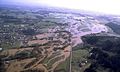
An aerial view of the 1996 flooding
-
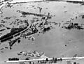
The remains of Vanport City in June 1948
See also
 In Spanish: Río Willamette para niños
- List of crossings of the Willamette River
- List of longest streams of Oregon
- List of rivers of Oregon
- Steamboats of the Willamette River
