Santiam River facts for kids
Quick facts for kids Santiam River |
|
|---|---|

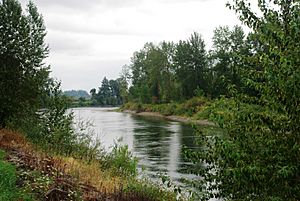
Near Interstate 5 in Linn County
|
|

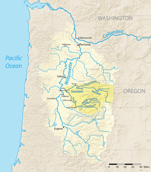
Map of the Willamette River watershed with the Santiam River highlighted
|
|
|
Location of the mouth of the Santiam River in Oregon
|
|
| Country | United States |
| State | Oregon |
| County | Linn and Marion |
| Physical characteristics | |
| Main source | confluence of North Santiam and South Santiam rivers Linn and Marion counties, Oregon 222 ft (68 m) 44°41′21″N 123°00′27″W / 44.68917°N 123.00750°W |
| River mouth | Willamette River between Albany and Salem, Marion County, Willamette Valley, Oregon 164 ft (50 m) 44°45′00″N 123°08′20″W / 44.75000°N 123.13889°W |
| Length | 12 mi (19 km) |
| Basin features | |
| Basin size | 1,830 sq mi (4,700 km2) |
The Santiam River is a river in western Oregon, United States. It flows into the Willamette River. The Santiam River is about 12 miles (19 km) long.
It gets its water from two main rivers: the North Santiam River and the South Santiam River. These rivers start in the Cascade Range. This mountain range is east of cities like Salem and Corvallis.
Contents
Where Does the Santiam River Start and End?
The Santiam River itself is quite short. It begins in the Willamette Valley. This is where the North Santiam and South Santiam rivers meet. This meeting point is on the border of Linn and Marion counties. It's about 8 miles (13 km) northeast of Albany.
From there, the river flows generally towards the west-northwest. It has a slow, winding path, which is called a meander. The Santiam River then joins the Willamette River. This happens about 8 miles (13 km) north of Albany.
The North and South Santiam Rivers
Both the North and South Santiam rivers begin high up in the Cascade Mountains. These mountains are in eastern Linn County.
The Middle Santiam River joins the South Santiam River. At this point, the South Santiam is held back by a dam. This creates a lake called Foster Lake.
The North Santiam River is also held back by a dam. This forms Detroit Lake. Detroit Lake is very deep, about 400 feet (120 m) deep. The Santiam River is an important source of water for the city of Salem.
Historical Events of the Santiam River
The Santiam River has seen some big events. One important event was the Great Willamette Flood of 1861. This flood happened on December 2. It caused a lot of damage to buildings and farms near where the Santiam River meets the Willamette River. Many animals were also affected.
Protecting the Santiam River Area
The Santiam River Zone is a special area. It has a team of firefighters called the Santiam Type 2 initial attack hand crew. There are also two fire engines. These teams are based out of the Detroit Ranger District.
Other fire crews from the Willamette National Forest also help. They are located in the Mckenzie and Middle Fork Ranger Districts. These teams work to protect the forests and lands around the river.
 | Sharif Bey |
 | Hale Woodruff |
 | Richmond Barthé |
 | Purvis Young |


