South Santiam River facts for kids
Quick facts for kids South Santiam River |
|
|---|---|

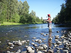
Fly fishing on the South Santiam River just downstream of Sweet Home
|
|
|
Location of the mouth of the South Santiam River in Oregon
|
|
| Country | United States |
| State | Oregon |
| County | Linn |
| Physical characteristics | |
| Main source | Jumpoff Joe Mountain Cascade Range, Willamette National Forest, Linn County, Oregon 1,932 ft (589 m) 44°22′27″N 122°13′05″W / 44.37417°N 122.21806°W |
| River mouth | Santiam River Willamette Valley, Linn County, Oregon 217 ft (66 m) 44°41′12″N 123°00′24″W / 44.68667°N 123.00667°W |
| Length | 69 mi (111 km) |
| Basin features | |
| Basin size | 1,040 sq mi (2,700 km2) |
The South Santiam River is a river in western Oregon, United States. It flows for about 69 miles (111 km). This river is a major branch of the Santiam River. It helps drain water from the Cascade Range mountains into the Willamette Valley. This valley is located east of the city of Corvallis.
The river starts in the Cascade Range mountains. Its source is in southeastern Linn County. This area is part of the Willamette National Forest. The river begins where two smaller streams, Sevenmile and Squaw creeks, meet.
From its start, the South Santiam River flows north for a short distance. Then, it generally turns west. It flows through the area known as the Western Cascades and past the town of Cascadia.
After flowing for a few miles, the river enters Foster Reservoir. This is a large lake created by a dam. Another river, the Middle Santiam River, joins the South Santiam here.
Downstream from Foster Reservoir, the river continues to flow west. It passes by the town of Sweet Home. Here, the river changes direction and flows northwest. It moves through the rolling hills and enters the flat Willamette Valley near Lebanon.
The South Santiam River then meets the North Santiam River. They join together to form the main Santiam River. This meeting point is about 15 miles (24 km) northeast of Lebanon. The Santiam River then flows about 10 miles (16 km) east before joining the larger Willamette River.
U.S. Route 20 is a major highway. It follows the river's path for much of its journey. You can see the river from the highway from its mountain beginnings to the Willamette Valley.
Contents
What Are the South Santiam River's Branches?
Many smaller streams and creeks flow into the South Santiam River. These are called tributaries. They add water to the main river as it flows from its source to its mouth.
Upper River Tributaries
Near where the river starts, you'll find Sevenmile Creek and Squaw Creek. Other creeks that join the river in its upper parts include:
- Three Creek
- Sheep Creek
- Elk Creek
- Soda Fork
- Stewart Creek
- Keith Creek
- Boulder Creek
- Little Boulder Creek
- Trout Creek
- Falls Creek
- Moose Creek
- Canyon Creek
- Wolfe Creek
Middle River Tributaries
Further downstream, more creeks join the South Santiam. These include:
- Dobbin Creek
- Soda Creek
- Cabin Creek
- Bucksnort Creek
- Mouse Creek
- Deer Creek
- Shot Pouch Creek
The Middle Santiam River is also a major tributary. It joins the South Santiam inside Foster Reservoir.
Lower River Tributaries
As the South Santiam River gets closer to its end, it is joined by:
- Ralston Creek
- Gadney Creek
- Wiley Creek
- Ames Creek
- Roaring Creek
- McDowell Creek
- Hamilton Creek
- Onehorse Creek
- Spring Branch
Finally, in its lowest sections, the river receives water from:
- Crabtree Creek
- Thomas Creek
- Mill Creek
The North Santiam River is the last major river to join. It combines with the South Santiam to form the larger Santiam River.
 | Valerie Thomas |
 | Frederick McKinley Jones |
 | George Edward Alcorn Jr. |
 | Thomas Mensah |


