Thomas Creek (Linn County, Oregon) facts for kids
Quick facts for kids Thomas Creek |
|
|---|---|

Hannah Bridge over Thomas Creek
|
|
|
Location of the mouth of Thomas Creek in Oregon
|
|
| Country | United States |
| State | Oregon |
| County | Linn County |
| Physical characteristics | |
| Main source | Willamette National Forest southwest of Detroit Lake 3,734 ft (1,138 m) 44°39′59″N 122°18′54″W / 44.66639°N 122.31500°W |
| River mouth | South Santiam River west of Scio 44°40′39″N 122°58′19″W / 44.67750°N 122.97194°W |
| Length | 35 mi (56 km) |
| Basin features | |
| Basin size | 117 sq mi (300 km2) |
Thomas Creek is a stream in Oregon, USA. It is about 35 miles (56 km) long. The creek starts in the Willamette National Forest. This forest is on the western side of the Cascade Range mountains.
Thomas Creek flows west through the Santiam State Forest. It also passes through farmland. Finally, it joins the South Santiam River near Scio.
Many years ago, several covered bridges were built over Thomas Creek. Three of these bridges are still standing today. They are important historical sites. Some other covered bridges were moved to different towns.
Sometimes, the creek can flood the town of Scio. This happened in 1964. The creek's fast flow makes it a good spot for whitewater sports. You can also find fish like smallmouth bass and cutthroat trout in the creek.
Contents
Exploring Thomas Creek's Path
Thomas Creek is a branch of the South Santiam River. It begins high up in the Cascade Range. The creek starts at about 3,700 feet (1,100 m) above sea level. This is southwest of Detroit Lake.
The creek flows west from its start. Smaller creeks like Hall Creek join it along the way. It then reaches the small community of Jordan. Jordan Creek also flows into Thomas Creek here.
Further downstream, more small streams add to Thomas Creek. The creek then passes a special measuring station. This station is near Scio. It measures how much water is flowing.
Thomas Creek then goes under Oregon Route 226. After that, it flows through Scio. Below Scio, another stream called Sucker Slough joins it. Finally, Thomas Creek flows into the South Santiam River. The South Santiam River then joins the North Santiam River. Together, they form the Santiam River, which flows into the Willamette River.
How Much Water Flows in Thomas Creek?
Scientists have measured the water flow in Thomas Creek for many years. From 1962 to 1987, and again from 2002 to 2013, they collected data. The average amount of water flowing near Scio was 487 cubic feet per second (13.8 m3/s).
The most water ever recorded was 27,400 cubic feet per second (780 m3/s). This happened on December 22, 1964. The least amount of water was 3.4 cubic feet per second (0.096 m3/s). This was on September 6, 2003. The area that drains into the creek above the measuring station is about 110 square miles (280 km2). This is most of the creek's total drainage area.
Understanding Floods in Scio
The town of Scio is built in a floodplain. This means there is a 1% chance of a flood happening each year. In December 1964, Scio was completely flooded. Thomas Creek and Peters Ditch overflowed their banks.
The water was usually shallow, but near the creek, it reached about 3 feet (1 m) deep. A flood of this size is expected only once every 200 years on average. This flood was part of a big series of floods across Oregon. It is known as the Christmas flood of 1964. The National Weather Service called it one of Oregon's top 10 weather events of the 20th century. In January 1972, Scio flooded again. The water flow at the measuring station reached 20,200 cubic feet per second (570 m3/s) during that flood.
Historic Covered Bridges

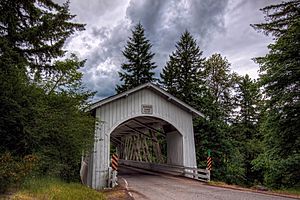
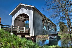
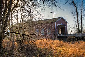
Many covered bridges have crossed Thomas Creek since the late 1800s. Some of these bridges replaced older ones that were damaged. Three covered bridges still cross the creek today. They are the Gilkey, Shimanek, and Hannah bridges. Two other bridges, the Weddle and Jordan, were moved to different cities.
The three bridges still over the creek are listed on the National Register of Historic Places. This means they are important historical sites. The Weddle Bridge was also listed but was removed after it was moved.
Gilkey Bridge
About 5 miles (8 km) from where Thomas Creek meets the South Santiam River, you'll find the Gilkey Bridge. It is a 120-foot (37 m) long bridge. It was built in 1939. A covered railroad bridge used to be next to it. The road bridge was damaged in 1997 but was fixed and reopened in 1998. The railroad bridge was removed in 1962. The Gilkey Covered Bridge carries Goar Road.
Weddle Bridge
The Weddle Bridge used to cross Thomas Creek near Scio. It was built in 1937 and was 120 feet (37 m) long. In the late 1980s, the bridge was old and not used anymore. It was going to be torn down. But people wanted to save it. This led to a special program in Oregon to protect covered bridges. The Weddle Bridge was the first to get help from this program. In 1989, it was moved to Sankey Park in Sweet Home, Oregon. It now crosses Ames Creek there.
Shimanek Bridge
The Shimanek Bridge is upstream of Scio. It is 130-foot (40 m) long and was built in 1966. It is the newest and longest covered bridge in Linn County. At least four other covered bridges were at this same spot before. Storms and floods damaged the older bridges. The Shimanek Bridge carries Richardson Gap Road.
Hannah Bridge
The Hannah Bridge crosses the creek about 1.5 miles (2.4 km) downstream from Jordan. It was built in 1936 and is 105 feet (32 m) long. Another covered bridge, built in 1912, was thought to be slightly upstream. It was taken apart, and its wood was used for farm buildings. Burmester Creek Road crosses the Hannah Bridge.
Jordan Bridge
The Jordan Bridge was built in 1937. It was 90-foot (27 m) long. In 1985, it was taken apart. Its wood was moved to Stayton and put back together in Pioneer Park. It was destroyed by fire in 1994 but was rebuilt in the park in 1998.
Fun Activities on Thomas Creek
Thomas Creek is a great place for outdoor fun!
- Fishing: You can find smallmouth bass and cutthroat trout here. There are also small numbers of Chinook salmon and steelhead. You cannot fish for salmon and steelhead. But you can fish for bass. You can also do catch-and-release fishing for trout.
- Whitewater Boating: If you like adventure, you can go whitewater canoeing or kayaking. A 5-mile (8 km) part of the upper creek is popular. It is rated as intermediate to advanced. Be careful of fast water, rocks, and logs.
- Another 9.5 miles (15.3 km) section, from 5-Mile Bridge to Hannah Bridge, is also used. It is rated as easy to intermediate. Sometimes you might need to carry your boat around obstacles. Watch out for low-hanging branches!


