Cascadia, Oregon facts for kids
Quick facts for kids
Cascadia, Oregon
|
|
|---|---|

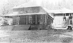
Hotel in Cascadia, circa 1925
|
|
| Country | United States |
| State | Oregon |
| County | Linn |
| Area | |
| • Total | 5.02 sq mi (13.00 km2) |
| • Land | 5.02 sq mi (13.00 km2) |
| • Water | 0.00 sq mi (0.00 km2) |
| Elevation | 810 ft (250 m) |
| Population
(2020)
|
|
| • Total | 134 |
| • Density | 26.70/sq mi (10.31/km2) |
| Time zone | UTC-8 (Pacific (PST)) |
| • Summer (DST) | UTC-7 (PDT) |
| ZIP codes |
97329, 97345
|
| FIPS code | 41-11700 |
| GNIS feature ID | 2584411 |
Cascadia is a small community in Oregon, United States. It is known as an unincorporated community. This means it does not have its own local government like a city. It is also a census-designated place (CDP). This is an area the government defines just for counting people.
Cascadia is located in Linn County, Oregon. It sits by the South Santiam River. The community is about 14 miles (22 km) east of the city of Sweet Home. In 2020, about 134 people lived in Cascadia.
Contents
History of Cascadia
Cascadia was started in 1892. It began as a stop for stagecoaches. These coaches traveled on the old Santiam Wagon Road.
A Popular Summer Resort
Cascadia became known as Cascadia Mineral Springs. People were drawn to the area because of its special spring waters. It turned into a popular place for summer vacations. A hotel was built there by George Geisendorfer. He also became the first postmaster in 1898. The community still has a post office today. Its main ZIP code is 97329.
In 1940, the land where the resort was located was sold to the state. Now, this area is part of the Cascadia State Park. This park covers about 300 acres (1.2 km²).
Climate in Cascadia
Cascadia has a type of weather called a warm-summer Mediterranean climate. This is often called "Csb" on climate maps. This means the summers are warm and dry. The average monthly temperatures do not go above 71.6°F (22°C).
People Living in Cascadia
Population Numbers
The number of people living in Cascadia changes over time.
| Historical population | |||
|---|---|---|---|
| Census | Pop. | %± | |
| 2020 | 134 | — | |
| U.S. Decennial Census | |||
In 2010, there were 147 people. By 2020, the population was 134 people.
Getting Around Cascadia
Main Roads
U.S. Route 20 is a major road that goes through Cascadia. This road helps people travel to other towns. If you go west on Route 20, you will reach Sweet Home in about 14 miles (22 km). Going further west, you can get to Albany in about 43 miles (69 km). If you travel east on Route 20, you will cross Tombstone Pass. This route leads to Bend, which is about 81 miles (130 km) away.
See also
 In Spanish: Cascadia (Oregón) para niños
 | William M. Jackson |
 | Juan E. Gilbert |
 | Neil deGrasse Tyson |


