Sweet Home, Oregon facts for kids
Quick facts for kids
Sweet Home, Oregon
|
|
|---|---|
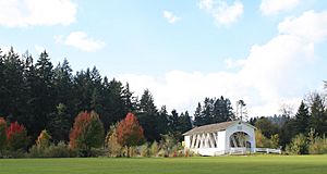
The Weddle Bridge spans Ames Creek in Sweet Home, Oregon.
|
|
| Motto(s):
Sweet Home: Oregon at its Best
Gateway to the Santiam Playground |
|
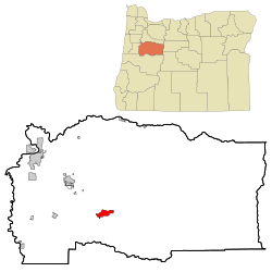
Location in Oregon
|
|
| Country | United States |
| State | Oregon |
| County | Linn |
| Incorporated | 1893 |
| Government | |
| • Type | Council-Manager |
| Area | |
| • Total | 5.76 sq mi (14.91 km2) |
| • Land | 5.30 sq mi (13.73 km2) |
| • Water | 0.46 sq mi (1.18 km2) |
| Elevation | 604 ft (184 m) |
| Population
(2020)
|
|
| • Total | 9,828 |
| • Estimate
(2023)
|
10,156 |
| • Density | 1,853.64/sq mi (715.65/km2) |
| Time zone | UTC-8 (Pacific) |
| • Summer (DST) | UTC-7 (Pacific) |
| ZIP code |
97386
|
| Area code(s) | 458 and 541 |
| FIPS code | 41-71950 |
| GNIS feature ID | 2412022 |
| Website | www.sweethomeor.gov |
Sweet Home is a city in Linn County, Oregon, United States. In 2020, about 9,828 people lived there. Sweet Home is often called the 'Gateway to the Santiam Playground'. This is because it is close to many lakes, rivers, and the Cascade Mountains. It's a great place for outdoor fun!
Contents
Sweet Home's Past
People first settled in the Sweet Home Valley in the early 1850s. A small community called Buckhead grew near Ames Creek and the South Santiam River. Buckhead got its name from a saloon that had elk antlers on its roof. East of Buckhead, another community named Mossville started with a store and a post office.
In 1874, these two communities joined together. They became one town called Sweet Home. The city of Sweet Home officially became a city in 1893.
The Santiam Wagon Road
The Santiam Wagon Road was a special road built in 1865. It was a toll road, meaning people paid to use it. This road connected the Willamette Valley with central Oregon. It went from Sweet Home Valley, over the Santiam Pass in the Cascades, to Camp Polk.
The Santiam Wagon Road was very important. It helped move farm animals and goods from western Oregon to central Oregon. It also brought wool from east of the Cascades back to factories in the Willamette Valley. By the late 1930s, new railroads and highways made the wagon road less important. Today, U.S. Route 20 follows much of the old wagon road's path.
Growth and Changes
Sweet Home grew a lot in the 1940s. This was because there was a high demand for timber from the local forests. The city grew even more when construction started on nearby Green Peter Dam in 1962 and Foster Dam in 1966.
In the 1980s, many sawmills and plywood factories in Sweet Home closed. This happened due to economic changes and new rules about logging to protect endangered animals. To help the city, people started looking for new ways to create jobs. One big success was the Oregon Jamboree, a country music and camping festival.
Sweet Home's Location and Nature
Sweet Home covers about 5.75 square miles (14.9 square kilometers). Most of this area is land, with a small part being water.
The main roads in Sweet Home are Oregon Route 228 and U.S. Route 20. They meet at the western edge of the city.
The South Santiam River flows along the northern edge of Sweet Home. It comes from Foster Reservoir. Smaller streams like Ames Creek and Wiley Creek also flow into the South Santiam River within the city.
Sweet Home is built on top of an ancient petrified forest. This means you can find fossilized wood here. The area also has many interesting rocks and minerals. These include agate, jasper, and various crystals. The petrified wood at Holleywood Ranch, near Sweet Home, was even featured on a TV show!
Sweet Home's Weather
Sweet Home has warm, dry summers. The average monthly temperatures are not too hot. The region has a "warm-summer Mediterranean climate." This means it has mild, wet winters and warm, dry summers.
| Climate data for Foster Dam, Oregon (1991–2020 normals, extremes 1969–present) | |||||||||||||
|---|---|---|---|---|---|---|---|---|---|---|---|---|---|
| Month | Jan | Feb | Mar | Apr | May | Jun | Jul | Aug | Sep | Oct | Nov | Dec | Year |
| Record high °F (°C) | 67 (19) |
71 (22) |
79 (26) |
86 (30) |
96 (36) |
112 (44) |
106 (41) |
105 (41) |
102 (39) |
93 (34) |
73 (23) |
69 (21) |
112 (44) |
| Mean maximum °F (°C) | 60.1 (15.6) |
63.6 (17.6) |
71.2 (21.8) |
77.6 (25.3) |
85.1 (29.5) |
89.8 (32.1) |
96.1 (35.6) |
97.1 (36.2) |
91.8 (33.2) |
79.7 (26.5) |
65.9 (18.8) |
59.2 (15.1) |
99.5 (37.5) |
| Mean daily maximum °F (°C) | 47.5 (8.6) |
51.2 (10.7) |
55.5 (13.1) |
60.3 (15.7) |
67.0 (19.4) |
72.9 (22.7) |
81.7 (27.6) |
82.6 (28.1) |
76.4 (24.7) |
64.1 (17.8) |
52.9 (11.6) |
46.5 (8.1) |
63.2 (17.3) |
| Daily mean °F (°C) | 40.9 (4.9) |
42.8 (6.0) |
46.2 (7.9) |
49.9 (9.9) |
55.5 (13.1) |
60.4 (15.8) |
66.4 (19.1) |
66.4 (19.1) |
61.6 (16.4) |
53.0 (11.7) |
45.3 (7.4) |
40.4 (4.7) |
52.4 (11.3) |
| Mean daily minimum °F (°C) | 34.3 (1.3) |
34.5 (1.4) |
36.9 (2.7) |
39.6 (4.2) |
43.9 (6.6) |
47.9 (8.8) |
51.0 (10.6) |
50.3 (10.2) |
46.8 (8.2) |
41.9 (5.5) |
37.6 (3.1) |
34.3 (1.3) |
41.6 (5.3) |
| Mean minimum °F (°C) | 22.7 (−5.2) |
24.4 (−4.2) |
27.2 (−2.7) |
31.1 (−0.5) |
34.6 (1.4) |
40.3 (4.6) |
43.8 (6.6) |
42.2 (5.7) |
38.0 (3.3) |
31.1 (−0.5) |
26.1 (−3.3) |
22.0 (−5.6) |
18.1 (−7.7) |
| Record low °F (°C) | 0 (−18) |
2 (−17) |
19 (−7) |
22 (−6) |
26 (−3) |
35 (2) |
39 (4) |
36 (2) |
31 (−1) |
20 (−7) |
16 (−9) |
0 (−18) |
0 (−18) |
| Average precipitation inches (mm) | 7.15 (182) |
5.56 (141) |
6.26 (159) |
5.37 (136) |
3.80 (97) |
2.46 (62) |
0.54 (14) |
0.64 (16) |
1.99 (51) |
4.64 (118) |
7.64 (194) |
8.40 (213) |
54.45 (1,383) |
| Average snowfall inches (cm) | 0.1 (0.25) |
0.0 (0.0) |
0.0 (0.0) |
0.0 (0.0) |
0.0 (0.0) |
0.0 (0.0) |
0.0 (0.0) |
0.0 (0.0) |
0.0 (0.0) |
0.0 (0.0) |
0.0 (0.0) |
0.0 (0.0) |
0.1 (0.25) |
| Average precipitation days (≥ 0.01 in) | 19.1 | 16.8 | 18.6 | 17.9 | 12.8 | 9.2 | 2.8 | 3.0 | 6.8 | 13.1 | 18.4 | 20.0 | 158.5 |
| Average snowy days (≥ 0.1 in) | 0.0 | 0.0 | 0.0 | 0.0 | 0.0 | 0.0 | 0.0 | 0.0 | 0.0 | 0.0 | 0.0 | 0.0 | 0.0 |
| Source: NOAA | |||||||||||||
Sweet Home's People
| Historical population | |||
|---|---|---|---|
| Census | Pop. | %± | |
| 1910 | 202 | — | |
| 1920 | 175 | −13.4% | |
| 1930 | 189 | 8.0% | |
| 1940 | 1,090 | 476.7% | |
| 1950 | 3,603 | 230.6% | |
| 1960 | 3,353 | −6.9% | |
| 1970 | 3,799 | 13.3% | |
| 1980 | 6,921 | 82.2% | |
| 1990 | 6,850 | −1.0% | |
| 2000 | 8,016 | 17.0% | |
| 2010 | 8,925 | 11.3% | |
| 2020 | 9,828 | 10.1% | |
| U.S. Decennial Census | |||
In 2020, Sweet Home had 9,828 people living in 3,721 households. The city's population density was about 1,684 people per square mile. Most residents (93.3%) were White. About 4.7% of the population was Hispanic or Latino.
The average age in Sweet Home was 39 years old. About 24.7% of the people were under 18 years old. The city had slightly more males (51.6%) than females (48.4%).
Sweet Home's Economy
Sweet Home has several important employers. These include Ti Squared Technologies, which makes titanium parts. White's Electronics makes metal detectors. HEVI-Shot produces ammunition. Cascade Timber Consulting manages timber investments. The United States Forest Service also has a presence. Other businesses include Radiator Supply House, Murphy Plywood, and McCool Millworks. The Sweet Home School District is also a major employer.
Arts and Fun in Sweet Home
Sweet Home is known for its fun events and beautiful bridges.
Yearly Events
- The Oregon Jamboree is a big country music and camping festival.
- The Cut the Gut Car Cruise is another popular event.
Covered Bridges
Sweet Home is home to the Weddle Covered Bridge. It was moved from another location and now crosses Ames Creek in Sankey Park. The Crawfordsville Covered Bridge is about 8 miles (13 km) southwest of Sweet Home. The Short Covered Bridge is about 12 miles (19 km) east of Sweet Home.
U.S. Capitol Christmas Tree
In 2018, the U.S. Capitol Christmas Tree came from the Sweet Home Ranger District. This district is part of the Willamette National Forest. Each year, a different national forest provides the Christmas tree for the U.S. Capitol.
Outdoor Activities
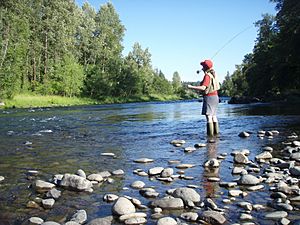
Sweet Home has seven city parks. But most of the outdoor fun happens outside the city. The nearby wilderness offers many activities. These include boating, hunting, fishing, hiking, and camping. People also enjoy white-water sports and even gold panning. This is why Sweet Home calls itself the "Gateway to the Santiam Playground."
Foster Reservoir on the South Santiam River has boat ramps and a marina. Green Peter Reservoir also has boat ramps. The South Santiam River is great for catching salmon and steelhead fish. Quartzville Creek is known for exciting kayaking.
You can also pan for gold in the South Santiam River. The nearby petrified wood deposits are still a big attraction.
For hiking, you can explore trails like Horse Rock Ridge and Soda Creek Falls Trail at Cascadia State Park. There are also many trails in the Willamette National Forest. The Menagerie Wilderness has cliffs that are good for climbing.
If you like golf, the Mallard Creek Golf Club is about 11 miles (18 km) northwest of Sweet Home. The closest place to ski is Hoo Doo Ski Bowl. It's about 52 miles (84 km) east, near Santiam Pass.
Getting Around Sweet Home
Public transportation in Sweet Home is provided by Linn Shuttle.
Learning in Sweet Home
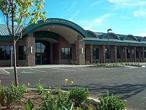
Sweet Home is served by the Sweet Home School District. This district includes Sweet Home High School, a junior high school, and four elementary schools. The district also covers nearby communities like Cascadia, Crawfordsville, Holley, and Pleasant Valley.
Linn–Benton Community College also has a branch campus in Sweet Home.
Sweet Home News
The local newspaper, The New Era, is published every week. The daily Albany Democrat-Herald also covers news for the city.
Famous People from Sweet Home
- Howard Bergerson (1922–2011), a writer who lived in Sweet Home.
- James McCarthy (1944–2019), a professor at Harvard University and a famous oceanographer. He grew up in Sweet Home.
- Ritch Price, a very successful baseball coach for the University of Kansas.
- Matt Slauson (born 1986), a professional football player for the Los Angeles Chargers. He played football at Sweet Home High School.
- Robert T Oliver, a scholar known for his work on communication.
See also
 In Spanish: Sweet Home (Oregón) para niños
 | Delilah Pierce |
 | Gordon Parks |
 | Augusta Savage |
 | Charles Ethan Porter |


