
Willamette Valley facts for kids
Quick facts for kids Willamette Valley |
|
|---|---|

Farmscape in northern Polk County
|
|

The Willamette Valley contains most of Oregon's population; it extends from the Portland metro area in the north to Eugene in the south.
|
|
| Geography | |
| Location | United States, Oregon |
| Borders on | Cascade Range (East) Oregon Coast Range (West) Calapooya Mountains (South) |
| Rivers | Willamette River |

The Willamette Valley (![]() i/wɪˈlæmɪt/ wil-AM-it) is a long valley in Oregon, United States. It stretches about 150 miles (240 km). The Willamette River flows through the entire valley. Mountains surround the valley on three sides. The Cascade Range is to the east. The Oregon Coast Range is to the west. The Calapooya Mountains are to the south.
i/wɪˈlæmɪt/ wil-AM-it) is a long valley in Oregon, United States. It stretches about 150 miles (240 km). The Willamette River flows through the entire valley. Mountains surround the valley on three sides. The Cascade Range is to the east. The Oregon Coast Range is to the west. The Calapooya Mountains are to the south.
This valley is very important to Oregon. About 70 percent of Oregon's people live here. This includes the state's five biggest cities. These cities are Portland, Eugene, Salem, Gresham, and Hillsboro.
The many rivers and streams, especially the Willamette River, are key to Oregon's economy. They bring rich, fertile soil to the valley floor. This makes the area great for farming. In the 1820s, people called the valley a "promised land." Many pioneers traveled here on the Oregon Trail in the 1800s.
Today, the valley is also known as "Oregon Wine Country." It has over 19,000 acres (7,700 ha) of vineyards. There are more than 500 wineries here.
Contents
How the Valley Was Formed
Much of the Willamette Valley's rich soil comes from huge ice-age floods. These floods happened many times. They came from Lake Missoula in Montana. The floodwaters swept across Eastern Washington. They carried topsoil down the Columbia River Gorge.
When the floodwaters reached Kalama, they backed up. This filled the entire Willamette Valley. The water was 300 to 400 feet (91 to 122 m) deep. Geologists think this happened many times during the last ice age. The water slowly drained away. It left layers of rich soil on the valley floor. This soil is about 180 to 200 feet (55 to 61 m) thick.
Geologists call the ancient lake that formed Lake Allison. It is named after Oregon State University geologist Ira S. Allison. He studied the valley's soil in 1953. He also found hundreds of large rocks called erratics. These rocks were carried by icebergs during the floods. They were left on the valley floor. One famous erratic is the Bellevue Erratic. It is near McMinnville.
Scientists also believe the Willamette Meteorite was carried by these floods. It was found in 1902 near West Linn.
Where is the Willamette Valley?
The Willamette Valley is a wide, flat area. It is bordered by the Oregon Coast Range to the west. The Cascade Range is to the east. To the south, the Calapooya Mountains separate it from the Umpqua River valley. Interstate 5 (I-5) runs through the entire valley. It connects all the main towns.
Sometimes, people do not include the Portland metropolitan area or the Tualatin River valley when talking about the Willamette Valley. But these areas are still part of the geographical valley.
Many cities are in the valley. From south to north, they include:
- Cottage Grove
- Eugene and Springfield (these two cities are very close)
- Corvallis
- Albany
- Dallas
- Salem
- Keizer
- McMinnville
- Hillsboro
Several counties are also part of the valley. These include Lane, Linn, Benton, Polk, Marion, Yamhill, and Washington counties.
Willamette Valley Weather

The Willamette Valley has mild weather. Winters are wet and cloudy. Summers are warm and sunny. It often rains from October to May. The heaviest rain is from November to January. This is when storms from the Pacific Ocean are strongest.
Winters are usually mild. Frosts happen at night, but daytime temperatures are almost always above freezing. Snow falls sometimes, but it is usually light. Very cold temperatures are rare. Summers are warm and sunny. There is not much humidity. Evenings are cool. Sometimes, it can get very hot, over 90°F (32°C) or even 100°F (38°C). But the nights usually cool down.
The amount of rain changes across the valley. Lower areas get about 36 inches (910 mm) of rain each year. Foothills can get over 80 inches (2,000 mm). Eugene, in the south, gets about 46 inches (1,200 mm) per year. Portland, in the north, gets about 36 inches (910 mm). The growing season for plants is long. It lasts 150 to 180 days in low areas.
Strong storms like tornadoes are rare. But they do happen a few times a year. They usually cause very little damage.
Farming in the Valley

The Willamette Valley is very rich for farming. This is because of the Missoula Floods. These floods brought rich volcanic and glacial soil from Eastern Washington. This soil was left on the valley floor when the water went away. In some places, the soil is about 0.5 miles (0.80 km) deep.
The valley's cool, moist climate is perfect for many crops. Farmers grow over 170 different kinds of crops and raise livestock. These include:
- Grass and legume seeds
- Tree fruits and nuts
- Wine grapes
- Berries
- Vegetables
- Nursery plants
- Christmas trees
- Field crops like wheat, oats, mint, and hops
- Hay, livestock, and poultry
The valley grows most of the cool-season grass, Christmas trees, and hazelnuts sold in North America. It is also famous for its hops. Hops are used to make craft beer.
_(yamDA0042).jpg)
In recent years, the valley has become a major wine producer. It has its own special wine regions called American Viticultural Areas. The Willamette Valley has a cooler climate than California. Its rolling hills are home to some of the best Pinot noir and Pinot gris wines in the world. Most wineries are found west of the Willamette River. They are on the slopes of the Coast Range. Yamhill County has the most wineries.

Farmers used to burn fields to help grow grass. This created a lot of smoke. In 1988, smoke caused a big car crash on I-5. Because of this, laws were made to limit burning. Since 2010, most field burning has been banned.
The marionberry is a special berry grown here. It is a mix of two types of blackberries. It was created at Oregon State University. It is named after Marion County in the Willamette Valley. The marionberry was introduced in the 1950s. People love its tart and sweet flavor. It tastes like a mix of raspberries and blackberries.
Nature and Environment

The Willamette Valley often experiences floods. Some big floods happened in 1862, 1899, 1964, and 1996. Part of the valley's flood area is a special protected place called the Willamette Floodplain.
Long ago, the Willamette Valley had mostly oak savanna. This was tall grasslands with scattered oak trees. There were also groves of Douglas-fir trees. The river areas had many wetlands. Native Americans living in the valley used to set fires often. This helped keep the grasslands open and stopped young trees from growing too much.
When American settlers arrived in the 1800s, they stopped these fires. They turned much of the valley into farms. This caused many grasslands to become forests again. Today, very little of the original oak savanna is left. One place where it is protected is Mount Pisgah Arboretum in Eugene.
Valley History
People have lived in the Willamette Valley for a very long time. It is thought that humans first arrived between 6,000 and 10,000 years ago. The valley was mainly home to the Kalapuya tribe of Native Americans. Molala and Chinook people also lived here. In the early 1800s, about 16,000 Kalapuya people lived in the valley.
They ate salmon, deer, and camas bulbs. They used fire to help the oak savanna grow. Oak trees also provided acorns for food. Today, the Kalapuya, Chinook, and Molala people are part of the Grand Ronde and Siletz Nations.
Between 1830 and 1833, many Kalapuya people died from a sickness. This greatly reduced their population.
In the early 1850s, the U.S. government forced all Indigenous peoples to leave the Willamette Valley. They had to give up their lands. They were moved to the Grande Ronde Reservation. Some went to the Siletz Reservation. Children were sometimes taken from their families to live in boarding schools, like the Chemawa Indian School in Salem. The people of the Confederated Tribes of Grand Ronde call this forced removal their "Trail of Tears."

After the Lewis and Clark Expedition reports came out around 1807, more pioneers started to settle in the valley. They used and improved trails made by fur traders. From 1841, when the Oregon Trail opened for wagons, many settlers came. They created new towns, with Oregon City as an early capital. So many settlers arrived that the valley helped Oregon become a U.S. state in 1859.
A small part of the Willamette Valley is in southwestern Washington. This includes the city of Vancouver. This was once the site of an early settlement called Fort Vancouver. The Willamette Valley became a major center for culture and business. It had sawmills, farms, and river transport. This helped the Oregon Country grow into the Oregon Territory.
The Hudson's Bay Company controlled the fur trade in the valley in the 1820s and 1830s. This ended in 1846 with the Oregon Treaty. This treaty gave the U.S. control of the region.
The Willamette Valley was connected to California's Central Valley by the Siskiyou Trail. The first European settlements were at Oregon City and Champoeg. The first college on the West Coast, Willamette University, was founded in Salem. It was started by Jason Lee, a missionary.
Images for kids
-
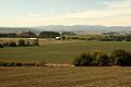
Farmscape in northern Polk County
-
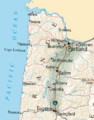
The Willamette Valley contains most of Oregon's population; it extends from the Portland metro area in the north to Eugene in the south.
-
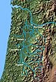
Willamette Valley drainage basin
-
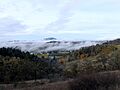
Light fog in the southern valley
-
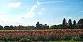
A field of Dahlias near Canby
-
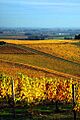
Fall grape vines in a Willamette Valley vineyard
-
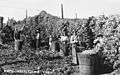
Harvesting hops near Independence, Oregon, circa 1940
-
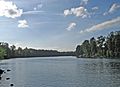
The Willamette River in the northern section of the valley
-
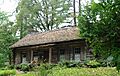
Pioneer cabin at Champoeg
