Tualatin Valley facts for kids
Quick facts for kids Tualatin Valley |
|
|---|---|

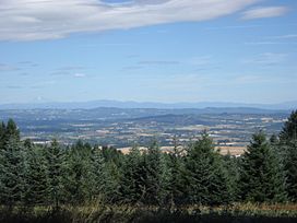
The Tualatin Valley from Bald Peak State Scenic Viewpoint
|
|

The Tualatin River
|
|
| Floor elevation | 180 ft (55 m) |
| Geography | |
| Location | Washington County & Clackamas County, Oregon |
| Borders on |
|
| Coordinates | |
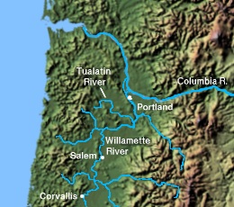
The Tualatin Valley is a special area in Oregon, USA, known for its farms and growing towns. It's located southwest of Portland. A winding river called the Tualatin River flows through it. This river eventually joins the Willamette River. The Tualatin Valley is at the northwest corner of the larger Willamette Valley.
Most of the valley is in Washington County. The Tualatin Mountains separate it from Portland. Many towns are in the Tualatin Valley, including Banks, Forest Grove, Cornelius, Hillsboro, Aloha, Beaverton, Sherwood, Tigard, and Tualatin.
Contents
A Look Back in Time
Early People and Names
Long ago, in the early 1800s, the Tualatin Valley was home to the Atfalati people. They were a group of Kalapuya people who hunted animals and gathered plants for food. They spoke a dialect of the Northern Kalapuya language.
By the mid-1800s, the Atfalati lived in several villages. One village was called Chakeipi, which meant "Place of the Beaver." Early European settlers called the area "Twality Plains." This was a changed version of the Atfalati tribe's name. Other old names included Falatin and Quality. These names often meant "slow river," describing the Tualatin River, or "land without trees."
Settlers and New Industries
The Tualatin Valley was one of the first farming areas settled in Oregon. People started arriving in 1840. In 1847, a man named Lawrence Hall claimed the first large piece of land. It was about 640 acres (2.6 square kilometers) near Beaver Dam, which later became Beaverton. He built the valley's first grist mill, which grinds grain into flour.
In 1849, Thomas Hicklin Denney and his wife Berrilla built the first sawmill in the Beaverton area. This led to a big increase in the timber industry, which cuts down trees for wood.
Connecting the Valley
Early settlers found it hard to move goods because there were no good roads. In 1850, the Oregon Territory created a company to build a road. This road would connect Portland with Beaverton through the Tualatin Hills. The road was finished in 1860, even with some money problems.
Historian Stewart Holbrook said this plank road was very important. It helped Portland become the main economic center, beating out Oregon City. Later, in 1868, a railroad was built into the valley.
Modern Growth and Changes
By the mid-1900s, farming in the valley needed more water. So, in 1966, the United States Bureau of Reclamation built the Tualatin Project. This project brought extra water to many parts of the valley for irrigation.
In the second half of the 1900s, the valley became more suburban. More towns and neighborhoods grew. Now, it's a distinct area with its own political and economic importance, similar to Portland. Towns along the Tualatin Valley Highway (which came from the old plank road) form a suburban corridor west of Beaverton.
Beaverton is famous for being the home of Nike, Inc., a huge sports company. Intel, a big technology company, is in Hillsboro. Both companies provide many jobs in the valley. Much of the valley is now part of Portland's urban growth boundary. This means new homes and businesses are built alongside farms and orchards.
Most towns in the valley use TriMet, Portland's public transportation system. In 1998, the MAX Light Rail train system was extended from Portland to Hillsboro.
Wine Country
The Tualatin Valley is on the edge of the Willamette Valley, which is famous for making wine. They are especially known for Pinot Noir wine. Ponzi Vineyards started in the Tualatin Valley in 1970. It was one of the first Oregon wineries to grow its own grapes for Pinot Noir. Their vineyards are certified as sustainable.
In 2020, two new wine regions, called American Viticultural Areas (AVAs), were approved: the Laurelwood District AVA and the Tualatin Hills AVA. These two AVAs share some borders and have a lot of special Laurelwood soils.
Geography of the Valley
The Tualatin River flows through the valley. The Tualatin Mountains border the valley to the north and east. These mountains are part of the Northern Oregon Coast Range, which also forms the valley's western border. To the south are the Chehalem Mountains. These mountains separate the Tualatin Valley from the main Willamette Valley.
The Tualatin River mostly flows from west to east. It leaves the valley in the southeast, near West Linn in Clackamas County. The center of the Tualatin Valley is southeast of Hillsboro. The valley's general elevation is about 180 feet above sea level.
Fun Places to Visit
- Tualatin River National Wildlife Refuge
- L.L. Stub Stewart State Park
- Scoggins Valley Park & Henry Hagg Lake
- Jackson Bottom Wetlands Preserve
- Rice Northwest Museum of Rocks and Minerals
Images for kids
-
Valley from the Chehalem Mountains on the southern end of the valley
 | Isaac Myers |
 | D. Hamilton Jackson |
 | A. Philip Randolph |


