
Hillsboro, Oregon facts for kids
Quick facts for kids
Hillsboro, Oregon
|
||
|---|---|---|
|
From top: Downtown with Mount Hood and Tuality Hospital in the background, City Hall, fountain at The Streets of Tanasbourne, Intel's Ronler Acres Campus, Main Street Bridge, Jerry Willey Plaza at Orenco Station Plaza
|
||
|
|
||
| Nickname(s):
The Hub City
|
||

Location of Hillsboro in the state of Oregon
|
||
| Country | United States | |
| State | Oregon | |
| County | Washington | |
| Settled | 1841 | |
| Laid Out | 1842 | |
| Incorporated | October 19, 1876 | |
| Named for | David Hill | |
| Government | ||
| • Type | Council–manager | |
| Area | ||
| • City | 25.86 sq mi (66.96 km2) | |
| • Land | 25.84 sq mi (66.93 km2) | |
| • Water | 0.01 sq mi (0.03 km2) | |
| Elevation | 148 ft (45 m) | |
| Population
(2020)
|
||
| • City | 106,447 | |
| • Estimate
(2022)
|
107,299 | |
| • Rank | US: 298th OR: 5th |
|
| • Density | 4,118.99/sq mi (1,590.33/km2) | |
| • Urban | 2,104,238 (US: 23rd) | |
| • Metro | 2,509,489 (US: 25th) | |
| Demonym(s) | Hillsboroans | |
| Time zone | UTC–8 (Pacific (PST)) | |
| • Summer (DST) | UTC–7 (PDT) | |
| ZIP codes |
97003, 97006, 97123, 97124
|
|
| Area code(s) | 503 and 971 | |
| FIPS code | 41-34100 | |
| GNIS feature ID | 2410765 | |


Hillsboro is a city in Oregon, a state in the United States. It is the main city of Washington County. Hillsboro is located in the Tualatin Valley, west of the Portland metropolitan area. Many high-tech companies, like Intel, are located here. This area is often called the Silicon Forest. In 2020, about 106,447 people lived in Hillsboro. This makes it the fifth-largest city in Oregon.
The city was started by settlers in 1842. It was later named after David Hill, an important person in Oregon's early days. In the past, people used riverboats on the Tualatin River to travel and trade. Later, railroads arrived in the 1870s, and electric trains came about 40 years after that. These transportation links helped the city grow slowly. By 1950, about 5,000 people lived there. Then, in the 1980s, many high-tech companies moved in, and the city grew much faster.
Hillsboro has a special type of government called a council–manager government. This means a city manager handles daily tasks, and a city council, led by a mayor, makes big decisions. Besides technology, important parts of Hillsboro's economy include healthcare, stores, and farming, especially grapes and wineries. The city has over twenty parks and a large stadium called Hillsboro Stadium. Ten places in Hillsboro are listed on the National Register of Historic Places. You can get around by car, public bus, light rail, or by flying from the Hillsboro Airport. Pacific University also has a campus in Hillsboro for health professions.
Contents
- History of Hillsboro
- Geography of Hillsboro
- Population of Hillsboro
- Economy of Hillsboro
- Arts and Culture in Hillsboro
- Sports in Hillsboro
- Parks and Recreation
- Education in Hillsboro
- Media in Hillsboro
- City Services and Transportation
- Notable People from Hillsboro
- Sister City
- Images for kids
- See also
History of Hillsboro
Early Settlement and Naming
The first European-American settlers, David Hill, Isaiah Kelsey, and Richard Williams, arrived in the Tualatin Valley in 1841. More pioneers joined them in 1842. The area was first called East Tualatin Plains or Columbia. In February 1850, it was named "Hillsborough" to honor David Hill. He sold some of his land to the county for the town.
On February 5, 1850, the area was chosen to be the county seat. David Hill was supposed to get $200 for his land, but he passed away before that. His wife, Lucinda, received the money instead. Later, the town's name was made simpler to Hillsboro. The first school was a log cabin built in 1853 and opened in October 1854. Riverboats started offering transportation to Hillsboro as early as 1867.

Growth and Government Changes
In 1871, the Oregon and California Railroad line reached the area. Hillsboro officially became a town on October 19, 1876. The first mayor was A. Luelling, who started his job on December 8, 1876. Important mayors later included Congressman Thomas H. Tongue. In 1923, the city changed its government to a council-manager system. This meant a city manager would run daily tasks, while the city council and mayor would make big decisions.
On September 30, 1908, a new electric rail line, the Oregon Electric Railway, connected Hillsboro to Portland. This was the first electric train to reach the city. Another electric train service, the Red Electric, started in 1914 but stopped in 1929. The Oregon Electric Railway's passenger service to Hillsboro ended in 1932.
City Services and Modern Era
Hillsboro built its first brick building for the county government in 1852. A new courthouse was built in 1928. The city's first fire department started in 1880. In 1892–93, Hillsboro got drinking water and electricity. The first sewer system was built in 1911, and a water system in 1913. The first public library, the Carnegie City Library, opened in December 1914.
In 1979, Intel opened its first facility nearby. This was followed by other Intel campuses in Hillsboro, making it a major tech hub. In 1998, the MAX light rail line opened, connecting Hillsboro to the wider Portland area. A cultural center was added in 2004, and a new city hall in 2005. In 2011, U.S. President Barack Obama visited Intel's campus in Hillsboro.
Geography of Hillsboro
Hillsboro covers about 21.6 square miles (56 square kilometers). The city is in the Tualatin Valley, and the Tualatin River forms part of its southern border. The land in Hillsboro is mostly flat, which was good for farming in the past. Hillsboro is about 17 miles (27 km) west of Portland. It is also just west of Beaverton. The city is about 148 feet (45 meters) above sea level.
Besides the Tualatin River, other streams in the area include Dairy Creek and McKay Creek. Nearby towns are Aloha, Cornelius, and North Plains.
Street System
Hillsboro has its own unique street system. Most streets in Washington County use a numbering system based on downtown Portland. But Hillsboro uses a grid system centered on Main Street (east-west) and First Avenue (north-south) in downtown. Most addresses have a direction prefix like NW, NE, SW, or SE. Even numbers are on the south side of streets and east side of avenues. Odd numbers are on the opposite sides.
North-south roads are called avenues, and east-west roads are called streets. Short, dead-end roads are called courts. Private roads are ways or places. Roads that curve are drives, and alleys are lanes.
Neighborhoods in Hillsboro

Hillsboro has several special areas with their own plans:
- Downtown: This is the original center of the city.
- Orenco: This area includes a former company town and the Orenco Station neighborhood. Orenco Station is designed to be a walkable area with mixed uses, where people rely less on cars.
- Hawthorn Farm / Fair Complex: This area is near the Hawthorn Farm light rail station and the Westside Commons (which used to be the Washington County Fairgrounds).
- Amberglen: This area is south of the Tanasbourne neighborhood. It is planned to be a lively center with good walking paths and green spaces, taking advantage of the light rail.
- South Hillsboro: This is a newer neighborhood designed to be a complete and green community. It has homes and businesses centered around a town center.
- North Hillsboro Industrial Area: This is where many of the Silicon Forest's manufacturing and technology companies are located. More than half of the city's jobs are in this area.
Climate and Weather
Hillsboro has warm summers, but the weather year-round is made milder by the nearby Pacific Ocean. Most of the rain falls in the winter, from November to March. Sometimes it snows. On average, Hillsboro gets rain about 161 days a year.
August is the warmest month, with an average high temperature of 81°F (27°C). January is the coolest month, with an average high of 46°F (8°C). The highest temperature ever recorded was 114°F (46°C) on June 28, 2021. The lowest was -14°F (-26°C) in January 1930. Hillsboro's climate is known as a warm-summer Mediterranean climate.
Population of Hillsboro
| Historical population | |||
|---|---|---|---|
| Census | Pop. | %± | |
| 1880 | 402 | — | |
| 1890 | 1,246 | 210.0% | |
| 1900 | 980 | −21.3% | |
| 1910 | 2,016 | 105.7% | |
| 1920 | 2,468 | 22.4% | |
| 1930 | 3,039 | 23.1% | |
| 1940 | 3,747 | 23.3% | |
| 1950 | 5,142 | 37.2% | |
| 1960 | 8,232 | 60.1% | |
| 1970 | 15,365 | 86.6% | |
| 1980 | 27,664 | 80.0% | |
| 1990 | 37,598 | 35.9% | |
| 2000 | 70,187 | 86.7% | |
| 2010 | 91,611 | 30.5% | |
| 2020 | 106,447 | 16.2% | |
| 2022 (est.) | 107,299 | 17.1% | |
| U.S. Decennial Census 2020 Census |
|||
Hillsboro's population grew from 402 people in 1880 to 2,016 by 1910. This made it the most populated city in the county at that time. By 1970, over 15,000 people lived there. In 2010, the population was 91,611, making it the fifth-largest city in Oregon. This was a 30.5% increase from 2000, showing Hillsboro was one of the fastest-growing cities in the state.
2020 Census Data
In 2020, Hillsboro had 106,447 people living in the city. There were about 40,891 households. About 27.8% of these households had children under 18. The average household size was 2.58 people. The median age in the city was 34.8 years old. About 20% of residents were under 18, and 11% were 65 or older. The population was almost equally split between males and females.
| Race | Number | Percentage |
|---|---|---|
| White (NH) | 56,716 | 53.28% |
| Black or African American (NH) | 2,950 | 2.77% |
| Native American or Alaska Native (NH) | 461 | 0.43% |
| Asian (NH) | 13,293 | 12.49% |
| Pacific Islander (NH) | 514 | 0.48% |
| Some Other Race (NH) | 588 | 0.55% |
| Mixed/Multi-Racial (NH) | 6,307 | 5.93% |
| Hispanic or Latino | 25,618 | 24.07% |
| Total | 106,447 | 100.00% |
Economy of Hillsboro
Hillsboro is a major center for technology companies, often called Oregon's Silicon Forest. Intel has its largest site here, with three big campuses and about 16,000 employees. Other tech companies like Synopsys and Salesforce also have facilities in Hillsboro. Hillsboro is also home to the main offices for companies like RadiSys and Planar Systems.
Manufacturing is the biggest job sector in Hillsboro, employing 24% of workers. Healthcare, education, and retail are also important. Many workers (68%) drive alone to work. The average commute time is about 24 minutes.

In 2006, Genentech, a biotechnology company, built a packaging and distribution center in Hillsboro. The city also has data centers for companies like Adobe and NetApp. This is because of the fiber optic cables that connect the U.S. across the Pacific Ocean, lower energy costs, and tax breaks.
Hillsboro is the main office for Rodgers Instruments, Soloflex, and Parr Lumber. The Laika stop-motion animation studio, which made movies like Coraline, is also in Hillsboro.

The Hatfield Government Center in Hillsboro is the end point of the MAX Blue Line light-rail system. This light rail helped create the walkable community of Orenco Station.
Hillsboro's main shopping areas are along Tualatin Valley Highway and Cornell Road. The Tanasbourne neighborhood has a large shopping center called The Streets of Tanasbourne. Another big shopping center is The Sunset Esplanade. In 2005, the world's largest Costco store opened in Hillsboro.
Top Employers in Hillsboro
Here are the largest employers in Hillsboro, based on a 2022 report:
| # | Employer | Type of Business | # of Employees | Percentage |
|---|---|---|---|---|
| 1 | Intel Corporation | Computer Electronics and Related Devices | 20,000 | 30.60% |
| 2 | Hillsboro School District | Education | 2,617 | 3.64% |
| 3 | Washington County | County Government | 2,306 | 3.21% |
| 4 | Nike | Administrative Offices | 1,832 | 2.55% |
| 5 | Tuality Healthcare and OHSU | Hospitals | 1,300 | 1.81% |
| 6 | City of Hillsboro | Local Government | 1,226 | 1.71% |
| 7 | Tokyo Electron America | Semiconductors and Related Devices | 1,200 | 1.67% |
| 8 | Amazon | Retail Delivery | 1,103 | 1.53% |
| 9 | Qorvo | Semiconductors and Related Devices | 1,085 | 1.51% |
| 10 | Kaiser Permanente | Medical | 1,064 | 1.48% |
| — | Total employers | — | 35,733 | 49.69% |
Arts and Culture in Hillsboro

Hillsboro has two movie theaters with a total of 29 screens. The Oregon Chorale (a choir), the Hillsboro Symphony Orchestra, and the Hillsboro Artists' Regional Theatre are also in the city. In 2004, the city opened the Glenn & Viola Walters Cultural Arts Center in a renovated church. This center has space for art shows, performances, and art classes. The Rice Northwest Museum of Rocks and Minerals is located on the northern edge of the city.
Hillsboro's annual Fourth of July Parade is the second-largest in Oregon. The Oregon International Air Show, the biggest air show in Oregon, happens every summer at the Hillsboro Airport. The city also has free summer concerts at Shute Park. The Washington County Fair is held every year at the Westside Commons (the county fairgrounds). A new conference center, the Wingspan Event & Conference Center, opened at the Commons in 2020.
Hillsboro has two library branches. The main branch, which is 38,000 square feet, opened in 2007. The smaller branch is in Shute Park. The Hillsboro libraries are part of a county-wide system, so residents can use other libraries in Washington County.
Historic Places in Hillsboro
Several places in and around Hillsboro are listed on the National Register of Historic Places. These include the Old Scotch Church, built in 1876. Near the Orenco neighborhood is Imbrie Farm, which has a house from 1866 and a barn that McMenamins turned into a brewpub. The Harold Wass Ray House, built in 1935, is near Intel's Hawthorn Farm campus.
In downtown Hillsboro, you can find historic homes like the Zula Linklater House (1923), Rice–Gates House (1890), and Edward Schulmerich House (around 1915). The Richard and Helen Rice House is next to the Sunset Highway and houses the Rice Northwest Museum of Rocks and Minerals. The Manning–Kamna Farm, with buildings from 1883, was added to the list in 2007. The Malcolm McDonald House in Orenco was added in 2015.
Hillsboro Landmarks
Landmarks in Hillsboro include the Washington County Courthouse, which is where the county government is located. The Hillsboro Pioneer Cemetery, started in 1870, is where many early settlers and politicians are buried. The Westside Commons, next to the airport, hosts the annual county fair.
-
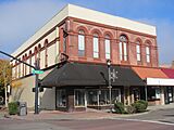
Morgan and Bailey Building
-
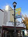
Hill Theatre, now an antique mall
-
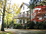
The Imbrie House
-
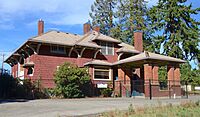
Malcolm McDonald House

_-_10.jpg)
_-_26.jpg)

.jpg)
Sports in Hillsboro
Hillsboro is home to two professional sports teams. The Portland Timbers 2 (T2) play soccer at Hillsboro Stadium. The Hillsboro Hops are a Minor League Baseball team connected with the Arizona Diamondbacks. The Hops moved to Hillsboro in 2012 and started playing at the new Ron Tonkin Field in 2013.
Parks and Recreation

.jpg)
Hillsboro's Parks and Recreation Department manages over 20 facilities. These include 23 parks and two sports complexes, like the Gordon Faber Recreation Complex which has Hillsboro Stadium and Ron Tonkin Field. The city also has the Walters Cultural Arts Center and the Shute Park Aquatic & Recreation Center. The city owns the Jackson Bottom Wetlands Preserve, a natural area along the Tualatin River.
Education in Hillsboro

Public schools in Hillsboro are run by the Hillsboro School District (1J). This district has 23 elementary schools, four middle schools, and four high schools. It also has an alternative school called the Miller Education Center. The district serves Hillsboro and nearby communities. In the 2022–23 school year, about 18,872 students were enrolled, making it the fourth-largest school district in Oregon.
The four main public high schools are:
| Name | Current campus | Enrollment (2022–23) | Nickname |
|---|---|---|---|
| Hillsboro High School | 1969 | 1,322 | Spartans |
| Glencoe High School | 1980 | 1,452 | Crimson Tide |
| Century High School | 1997 | 1,533 | Jaguars |
| Liberty High School | 2003 | 1,483 | Falcons |
For higher education, Oregon Health & Science University (OHSU) has a west campus in Hillsboro. Pacific University also has a Health Professions Campus downtown. Other options include the Work Force Training Center (Portland Community College) and a branch of the University of Phoenix. Hillsboro also has private schools like Faith Bible High School and St. Matthew Catholic School.
Media in Hillsboro
The weekly Hillsboro Tribune used to be based in Hillsboro. In 2019, it was replaced by a Hillsboro edition of the News-Times. The city's old newspaper, the Hillsboro Argus, was published for over 120 years until 2017.
Hillsboro also gets news from Portland-based media, including The Oregonian newspaper. Local FM radio station KQRZ-LP plays Oldies music.
City Services and Transportation
Transportation in Hillsboro

Public transportation in Hillsboro includes buses and light rail, managed by TriMet. The MAX Blue Line light rail started serving Hillsboro on September 12, 1998. The western end of the line is downtown. The Willow Creek and Hillsboro transit centers are major hubs for the public transit system. There are also seven other MAX stations in the city. The Hillsboro Intermodal Transit Facility, which opened in 2010, is a parking garage near the Tuality Hospital station. It has bike lockers and electric vehicle charging stations. The MAX Red Line was also extended to the Fairgrounds station in 2024.
Freight train services from Portland and Western Railroad connect Hillsboro to other major rail lines. The city does not have passenger train service. For air travel, there is the Hillsboro Airport in the city center. It is the second-busiest airport in Oregon, mainly used for private and corporate flights.
Oregon Route 8, also known as the Tualatin Valley Highway (TV Highway), is the main east-west road. U.S. Route 26, or the Sunset Highway, crosses the northeast part of the city. Other important roads include Cornell Road and Main Street. Major north-south roads are Oregon Route 219 / 1st Avenue and Cornelius Pass Road.
City Services
Hillsboro manages its own services, including:
- A library system
- A fire department with five stations
- A parks department
- A water system
- A police department with two main offices
- A city-run internet service called HiLight, which started in 2020.
Wastewater treatment is handled by Clean Water Services, which serves the whole county.
Notable People from Hillsboro
Many interesting people have lived in Hillsboro over the years. These include David Hill, who founded the city, and Tiffeny Milbrett, an Olympic and World Cup champion soccer player. Sydney Collins is a player for the Canada national soccer team. Two governors of Oregon, James Withycombe and Paul L. Patterson, lived in Hillsboro.
Other notable people include Congressmen Thomas H. Tongue and Samuel Thurston. Athletes like Erik Ainge, Scott Brosius, and Olympic medalists Josh Inman have also called Hillsboro home. The city has also been home to Esperanza Spalding, a musician, and professional wrestler Roddy Piper.
Sister City
Hillsboro has one sister city: Fukuroi, Japan. Fukuroi is a city of about 85,000 people in central Japan. Both cities have similar economies, focusing on farming and high technology. Their sister city relationship began in November 1988. This relationship includes student exchange programs between schools in both cities.
Images for kids
-
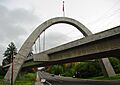
Main Street Bridge
-
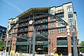
Jerry Willey Plaza at Orenco Station Plaza
See also
 In Spanish: Hillsboro (Oregón) para niños
