Mount Hood facts for kids
Quick facts for kids Mount Hood |
|
|---|---|
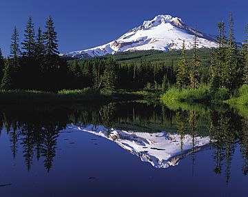
Mount Hood reflected in Mirror Lake
|
|
| Highest point | |
| Elevation | 11,249 ft (3,429 m) NAVD 88 |
| Prominence | 7,706 ft (2,349 m) |
| Listing |
|
| Naming | |
| Language of name | Multnomah |
| Geography | |
| Location | Clackamas / Hood River counties, Oregon, U.S. |
| Parent range | Cascade Range |
| Topo map | USGS Mount Hood South |
| Geology | |
| Age of rock | More than 500,000 years |
| Mountain type | Stratovolcano |
| Volcanic arc | Cascade Volcanic Arc |
| Last eruption | 21 September 1865 to January 1866 |
| Climbing | |
| First ascent | July 11, 1857, by Henry Pittock, W. Lymen Chittenden, Wilbur Cornell, and the Rev. T. A. Wood |
| Easiest route | Rock and glacier climb |
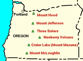
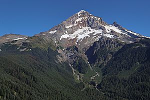
Mount Hood is a tall, active stratovolcano in the Cascade Mountains. It was formed when Earth's plates moved under each other near the Pacific coast. This mountain is located in the Pacific Northwest region of the United States. It's about 50 miles (80 km) southeast of Portland, on the border of Clackamas and Hood River counties.
Mount Hood is Oregon's highest mountain. It is also one of the tallest mountains in the nation based on its height compared to nearby land. It is special because it offers the only year-round skiing in North America where you can use a ski lift.
The height of Mount Hood's snow-covered peak has been measured differently over time. Today, it is usually said to be 11,249 feet (3,429 meters) tall. This measurement was updated in 1991. The peak has 12 named glaciers and snowfields. Mount Hood is the fourth highest point in the entire Cascade Range.
Scientists believe Mount Hood is the Oregon volcano most likely to erupt. However, based on its past, a big, explosive eruption is not expected. There is a small chance, about 3 to 7%, that it could erupt in the next 30 years. The U.S. Geological Survey (USGS) calls it "potentially active." But most people think of it as a dormant (sleeping) volcano.
Contents
Fun Things to Do on Mount Hood

Timberline Lodge is a famous building on the south side of Mount Hood. It is a National Historic Landmark. The lodge is located just below the Palmer Glacier, at an elevation of about 6,000 feet (1,800 meters).
Mount Hood has four main ski areas: Timberline, Mount Hood Meadows, Ski Bowl, and Cooper Spur. Together, they offer over 4,600 acres (19 km²) of ski slopes. Timberline is unique because it has a ski lift that runs all year long. This makes it the only place in North America where you can ski with a lift in every season.
There are also a few old shelters on Mount Hood that people still use. These include the Coopers Spur, Cairn Basin, and McNeil Point shelters. The Tilly Jane A-frame cabin is also a popular spot. Long ago, in the early 1900s, there was a fire lookout tower at the summit. But it could not stand up to the harsh weather and is no longer there.
Mount Hood is part of the Mount Hood National Forest. This huge forest covers over 1 million acres (4,300 km²). It includes four special wilderness areas and more than 1,200 miles (1,900 km) of hiking trails.
Lolo Pass is a path on the northwest side of the mountain. Native Americans used this pass to travel between the Willamette Valley and Celilo Falls.
How Mount Hood Got Its Name
Native American Names and Legends
The name Wy'east has been linked to Mount Hood for over a hundred years. However, there is no clear proof that this was a real name for the mountain in any native language. The name might have come from a story by author Frederic Balch in 1890. It may have become popular when his story was used in a play around 1911.
One version of Balch's story tells of two sons of the Great Spirit Sahale. They both fell in love with a beautiful maiden named Loowit. She could not choose between them. The two brave brothers, Wy'east and Pahto, fought over her. Their battle caused fires and destroyed villages. Sahale became angry and struck down the three lovers. To remember them, he created three mountain peaks where each fell. He made beautiful Mount St. Helens for Loowit, proud Mount Hood for Wy'east, and sad Mount Adams for the mourning Pahto.
Other versions of the legend exist. In one, Wy'east (Mount Hood) fights Pahto (Mount Adams) for the lovely La-wa-la-clough (Mount St. Helens). Another story says Wy'east, the chief of the Multnomah tribe, fought with the chief of the Klickitat tribe. Their great anger turned them into volcanoes. Their battle is said to have destroyed the Bridge of the Gods. This created the big Cascades Rapids in the Columbia River.
Part of the mountain is on the land of the Confederated Tribes of Warm Springs. Three languages are spoken by these tribes: Sahaptin, Upper Chinook/Kiksht (Wasco), and Numu (Paiute). So, choosing one original native name for the mountain would be difficult.
The Current Name of Mount Hood
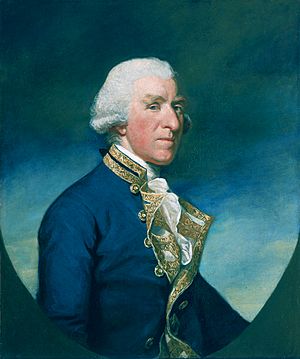
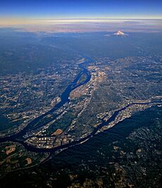
The mountain got its current name on October 29, 1792. It was named by Lt. William Broughton, who was part of Captain George Vancouver's exploration trip. Lt. Broughton saw the peak while on what is now called Sauvie Island. He was traveling up the Columbia River and wrote about the "very high, snowy mountain." He named it after Samuel Hood, 1st Viscount Hood, a British admiral.
The Lewis and Clark explorers saw the mountain on October 18, 1805. A few days later, Clark wrote about "the pinnacle of the round topped mountain." He called it the Falls Mountain, or Timm Mountain, after the native name for Celilo Falls. Clark later noted that it was also Vancouver's Mount Hood.
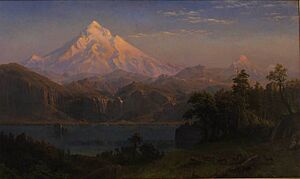
Two French explorers from the Hudson's Bay Company might have visited the area east of Mount Hood in 1818. They said they climbed a glacier on "Montagne de Neige" (Mountain of Snow). This was likely the Eliot Glacier.
Things Named After Mount Hood
Two United States Navy ships that carried ammunition were named after Mount Hood. The first, USS Mount Hood (AE-11), was launched in 1944. It was sadly destroyed later that year when its cargo exploded. This accident caused many deaths and injuries. A second ship, AE-29, was used from 1971 to 1999.
Volcanic Activity and History
Mount Hood's top area has been shaped by glaciers. It has several lava domes made of andesitic or dacitic rock. In the past, parts of the volcano collapsed. This caused huge avalanches and lahars (fast-moving mudflows) that reached the Columbia River. The volcano has had at least four major periods of eruption over the last 15,000 years.
The last three eruptions happened within the past 1,800 years. They came from vents high on the southwest side of the mountain. These eruptions mostly sent rock and mudflows to the south and west, along the Sandy and Zigzag rivers. The most recent eruptive period was about 220 to 170 years ago. During this time, lava domes, ash flows, and mudflows were created. There were no big explosions. The large rock called Crater Rock, just below the summit, is thought to be what is left of one of these old lava domes. This period includes a major eruption in 1781 to 1782. A smaller event ended just before the Lewis and Clark explorers arrived in 1805.
The glaciers on Mount Hood's upper slopes could cause dangerous lahars if the mountain erupts again. There are vents near the summit that release gases like carbon dioxide and sulfur dioxide. In 1934, a climber died on Mount Hood while exploring ice caves. The air in these caves, melted by hot gases called fumaroles, had very little oxygen.
Since 1950, there have been several groups of small earthquake swarms each year at Mount Hood. The most noticeable ones were in July 1980 and June 2002. The USGS Cascades Volcano Observatory watches the mountain's seismic activity. They provide weekly updates.
The most recent signs of volcanic activity are the fumaroles near Crater Rock. There are also hot springs on the sides of the volcano. These show that the mountain is still active.
Mount Hood's Changing Height
Mount Hood was first seen by European explorers in 1792. It is believed that its summit has stayed about the same height, only changing by a few feet. This is due to small earthquakes. Changes in its reported height since the 1950s are mostly because of better ways to measure and more accurate models of Earth's shape.
Early explorers on the Columbia River guessed the mountain was between 10,000 and 12,000 feet (3,000 to 3,700 meters) tall. In 1854, two people on an expedition thought it was 18,361 feet (5,596 meters) high. Another person claimed it was 19,400 feet (5,900 meters) after climbing it. Many maps in the late 1800s showed it as 18,361 feet. For a while, some people even thought Mount Hood was the highest point in North America!
Today, modern height surveys still vary a little, but not by as much as in the past. A scientific team in 1993 measured the peak at 11,240 feet (3,426 meters). They said this was very accurate. Many sources today list 11,240 feet as the height. However, others say it is 11,239 feet (3,426 meters). Finally, a height of 11,249 feet (3,429 meters) has also been reported.
Glaciers of Mount Hood
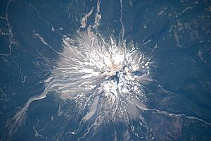
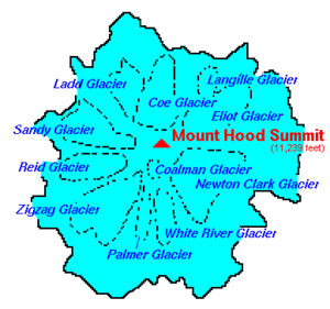
Mount Hood has 12 named glaciers or snow fields. The most visited is Palmer Glacier, which is partly within the Timberline Lodge ski area. This glacier is also on the most popular climbing route. Most of the glaciers are above 6,000 feet (1,800 meters). This is also about where the tree line ends on Mount Hood. More than 80% of the glacier surface area is above 7,000 feet (2,100 meters).
The glaciers and permanent snow fields cover an area of about 3,331 acres (13.48 km²). They hold a large amount of water, about 282,000 acre-feet (0.348 km³). Eliot Glacier is the largest by volume. It has the thickest ice, measured at 361 feet (110 meters) deep. The Coe-Ladd Glacier system is the largest by surface area, covering 531 acres (2.15 km²).
Glaciers and snowfields cover about 80% of the mountain above 6,900 feet (2,100 meters). From 1907 to 2004, the glaciers shrank by about 34% on average. They retreated (got smaller) through the first half of the 20th century. Then, they grew or slowed their retreat in the 1960s and 1970s. Since then, they have been shrinking again. The largest recent glacier sizes were in the early 1700s.
During the last major ice age, between 29,000 and 10,000 years ago, glaciers reached down to about 2,300 to 2,600 feet (700 to 790 meters). This was about 9.3 miles (15 km) from the summit. As they melted, they left behind a lot of rock and sediment. This filled and flattened the upper Hood River Valley near Parkdale and formed Dee Flat.
Older ice ages left behind piles of rock called moraines near Brightwood. They also created distinct cuts on the southeast side of the mountain. These might be as old as 140,000 years.
Hiking Adventures
The Mount Hood forest has about 1,000 miles (1,600 km) of trails. The Coopers Spur trail goes up to 8,510 feet (2,594 meters). This is the highest point you can reach on the mountain without needing special climbing gear.
The Timberline Trail goes all the way around the mountain. It reaches as high as 7,300 feet (2,200 meters). This trail was built in the 1930s by the Civilian Conservation Corps. Usually, the 40.7-mile (65.5 km) hike is clear of snow from late July until the first snows of autumn. The trail involves climbing and descending over 10,000 feet (3,000 meters) in total. Its exact length can change each year because of river crossings. There are many places to start the trail, with the shortest walk from the Timberline Lodge. A part of the Pacific Crest Trail follows the Timberline Trail on the west side of Mount Hood.
The Oregon Skyline Trail was the path before the Pacific Crest Trail. It was created in 1920 and connected Mount Hood to Crater Lake.
Climbing Mount Hood
Mount Hood is Oregon's highest point. It is a famous landmark that can be seen from up to 100 miles (160 km) away. About 10,000 people try to climb Mount Hood each year. It is easy to get to, but it offers some tough climbing challenges. There are no simple trails to the very top. Even the "easier" southside climbing route is a technical climb. It has deep cracks in the ice (crevasses), falling rocks, and often bad weather. You need ropes, ice axes, crampons, and other special mountaineering gear. The best time to climb is usually from April to mid-June.
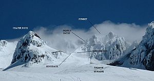
There are six main ways to approach the mountain. There are also about 30 different ways to reach the summit. The climbs range from easy to very difficult. The most popular route is called the south route. It starts at Timberline Lodge and goes up Palmer Glacier to Crater Rock. Crater Rock is a large rock formation at the top of the glacier. The route then goes east around Crater Rock and crosses the Coalman Glacier. This leads to the Hogsback, a ridge that goes from Crater Rock towards the summit. The Hogsback ends at a bergschrund, which is a big crack where the Coalman Glacier separates from the rock face of the summit. The route then continues to the Pearly Gates, a gap in the summit rocks. From there, climbers go onto the summit plateau and reach the top.
Because of changing conditions, climbers now need special ice axes and fall protection. Experience is also recommended for certain parts of the climb. The Forest Service suggests other route options due to these changes.
Safety on Mount Hood Climbs
Climbing Mount Hood can be dangerous. Since records began in 1896, many people have faced serious challenges or accidents. While avalanches are a risk on other icy mountains, most incidents on Mount Hood are due to falls and hypothermia (getting too cold). About 50 people need rescue each year. Safety is very important when climbing this mountain.
Mount Hood's Climate
The summit of Mount Hood has a typical cold, dry-summer alpine climate. Temperatures are below 32°F (0°C) for eight months of the year. No month has an average temperature above 50°F (10°C). Even in the warmest months, night temperatures often drop below freezing. Frost happens almost every day, even in summer.
| Climate data for Mount Hood, 1991–2020 normals (3001m) | |||||||||||||
|---|---|---|---|---|---|---|---|---|---|---|---|---|---|
| Month | Jan | Feb | Mar | Apr | May | Jun | Jul | Aug | Sep | Oct | Nov | Dec | Year |
| Mean daily maximum °F | 24.5 | 23.8 | 24.7 | 28.3 | 37.0 | 44.0 | 54.9 | 55.2 | 50.1 | 39.7 | 27.9 | 23.3 | 36.1 |
| Daily mean °F | 18.9 | 16.9 | 16.9 | 19.4 | 27.0 | 33.2 | 42.6 | 43.0 | 38.5 | 30.2 | 21.8 | 17.9 | 27.2 |
| Mean daily minimum °F | 13.3 | 10.0 | 9.0 | 10.5 | 16.9 | 22.4 | 30.3 | 30.7 | 26.9 | 20.8 | 15.7 | 12.5 | 18.3 |
| Average precipitation inches | 17.99 | 13.55 | 14.29 | 11.40 | 7.67 | 5.84 | 1.37 | 1.82 | 4.57 | 10.86 | 17.45 | 18.83 | 125.64 |
| Mean daily maximum °C | −4.2 | −4.6 | −4.1 | −2.1 | 2.8 | 6.7 | 12.7 | 12.9 | 10.1 | 4.3 | −2.3 | −4.8 | 2.3 |
| Daily mean °C | −7.3 | −8.4 | −8.4 | −7.0 | −2.8 | 0.7 | 5.9 | 6.1 | 3.6 | −1.0 | −5.7 | −7.8 | −2.7 |
| Mean daily minimum °C | −10.4 | −12.2 | −12.8 | −11.9 | −8.4 | −5.3 | −0.9 | −0.7 | −2.8 | −6.2 | −9.1 | −10.8 | −7.6 |
| Average precipitation mm | 457 | 344 | 363 | 290 | 195 | 148 | 35 | 46 | 116 | 276 | 443 | 478 | 3,191 |
| Average dew point °F | 12.8 | 9.6 | 8.6 | 10.5 | 16.0 | 21.0 | 26.5 | 25.4 | 21.4 | 18.4 | 15.1 | 12.7 | 16.5 |
| Average dew point °C | −10.7 | −12.4 | −13.0 | −11.9 | −8.9 | −6.1 | −3.1 | −3.7 | −5.9 | −7.6 | −9.4 | −10.7 | −8.6 |
| Source: PRISM Climate Group | |||||||||||||
| Climate data for Mount Hood 45.3744 N, 121.6999 W, Elevation: 10,407 ft (3,172 m) (1991–2020 normals) | |||||||||||||
|---|---|---|---|---|---|---|---|---|---|---|---|---|---|
| Month | Jan | Feb | Mar | Apr | May | Jun | Jul | Aug | Sep | Oct | Nov | Dec | Year |
| Mean daily maximum °F | 22.8 | 22.1 | 23.0 | 26.6 | 35.3 | 42.4 | 53.2 | 53.5 | 48.4 | 38.1 | 26.3 | 21.7 | 34.5 |
| Daily mean °F | 17.1 | 15.1 | 15.0 | 17.6 | 25.1 | 31.4 | 40.8 | 41.1 | 36.7 | 28.5 | 20.1 | 16.2 | 25.4 |
| Mean daily minimum °F | 11.4 | 8.0 | 7.1 | 8.5 | 14.9 | 20.5 | 28.3 | 28.7 | 25.0 | 19.0 | 13.9 | 10.7 | 16.3 |
| Average precipitation inches | 17.24 | 13.05 | 13.90 | 10.94 | 7.40 | 5.60 | 1.34 | 1.77 | 4.52 | 10.64 | 16.74 | 18.63 | 121.77 |
| Mean daily maximum °C | −5.1 | −5.5 | −5.0 | −3.0 | 1.8 | 5.8 | 11.8 | 11.9 | 9.1 | 3.4 | −3.2 | −5.7 | 1.4 |
| Daily mean °C | −8.3 | −9.4 | −9.4 | −8.0 | −3.8 | −0.3 | 4.9 | 5.1 | 2.6 | −1.9 | −6.6 | −8.8 | −3.7 |
| Mean daily minimum °C | −11.4 | −13.3 | −13.8 | −13.1 | −9.5 | −6.4 | −2.1 | −1.8 | −3.9 | −7.2 | −10.1 | −11.8 | −8.7 |
| Average precipitation mm | 438 | 331 | 353 | 278 | 188 | 142 | 34 | 45 | 115 | 270 | 425 | 473 | 3,092 |
| Source: PRISM Climate Group | |||||||||||||
More About Mount Hood
 In Spanish: Monte Hood para niños
- Gentlemen's Race (2008)
- List of Ultras of the United States
- Mount Hood climbing accidents
- Mount Hood Corridor
- Mount Hood Railroad
 | Jessica Watkins |
 | Robert Henry Lawrence Jr. |
 | Mae Jemison |
 | Sian Proctor |
 | Guion Bluford |


