Zigzag River facts for kids
Quick facts for kids Zigzag River |
|
|---|---|

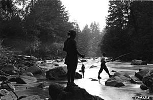
Fishing on the Zigzag River
|
|

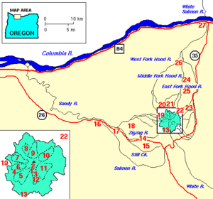
Mount Hood and vicinity
|
|
|
Location of the mouth of the Zigzag River in Oregon
|
|
| Country | United States |
| State | Oregon |
| County | Clackamas County |
| Physical characteristics | |
| Main source | Zigzag Glacier Mount Hood 7,113 ft (2,168 m) 45°21′11″N 121°43′11″W / 45.35306°N 121.71972°W |
| River mouth | Sandy River near Zigzag, Oregon 1,375 ft (419 m) 45°20′54″N 121°56′44″W / 45.34833°N 121.94556°W |
| Length | 12 mi (19 km) |
The Zigzag River is a river in Oregon, United States. It is about 12 miles (19 km) long. The river flows into the Sandy River. The Zigzag River and its smaller branch, the Little Zigzag River, get their water from the Zigzag Glacier. This glacier is located on Mount Hood, a tall volcano in the Cascade Range. The river's water flows west. It meets the Sandy River near the town of Zigzag.
Contents
What's in a Name?
The river's name comes from a description by Joel Palmer. He was an early explorer in Oregon. In 1845, he described going down a river canyon. This canyon was later named Zigzag Canyon. It starts on Mount Hood. The river's winding path likely reminded him of a zigzag shape.
River's Journey
The Zigzag River starts high up on Mount Hood. It begins at the Zigzag Glacier. From its source, the river drops about 5,738 feet (1,749 m) in height. This means it flows downhill quite steeply. On average, it drops about 475 feet per mile (90.0 m/km) for every mile it travels.
The river's flow changes throughout the year. It can range from about 200 cubic feet per second (5.7 m3/s) to 1,000 cubic feet per second (28 m3/s). This means the amount of water moving through it can vary a lot.
Exploring the Area
The area around the upper Zigzag River is very dramatic. It has steep cliffs and beautiful views. The 41-mile (66 km) Timberline Trail crosses the Zigzag River here. Another path, the Paradise Park Loop Trail, crosses a smaller stream that feeds into the Zigzag.
The Pacific Crest Trail also follows this route. This trail is famous for long-distance hikers. Sometimes, parts of the Timberline Trail need to be rebuilt. This happens because of avalanches, which are large slides of snow and ice.
Waterfalls and Popular Spots
The Little Zigzag River has a beautiful waterfall. It's called Little Zigzag Falls and is 75 feet (23 m) tall. This waterfall is one of the most popular places to visit in the Zigzag area.
Other popular spots include Mirror Lake. This lake is on a stream called Camp Creek, which also flows into the Zigzag River. Another busy area is near Timberline Lodge. This lodge is a famous building on Mount Hood.
Mountains and Wilderness
Besides Mount Hood, the highest point in the Zigzag River area is Devils Peak. It is 5,045 feet (1,538 m) tall. There used to be a fire tower on Devils Peak. Now, hikers can use it to stay overnight.
Parts of the Zigzag River area are protected. The northern part of the watershed is in the Mount Hood Wilderness. This means it's a wild area where nature is preserved. There are also plans to add more land to the Salmon-Huckleberry Wilderness.
River Activities
The last 3.2 miles (5.1 km) of the Zigzag River is popular for whitewater boating. This section is rated Class III (difficult) to Class IV (very difficult). This means the rapids are challenging and exciting for experienced boaters. The river drops about 108 feet per mile (20.5 m/km) in this part.
Fishing
You can fish for coastal cutthroat trout in the Zigzag River. However, it's a catch-and-release area for these fish. This means you must let them go after you catch them. Fishing for salmon and steelhead is not allowed in the Zigzag River.
 | George Robert Carruthers |
 | Patricia Bath |
 | Jan Ernst Matzeliger |
 | Alexander Miles |


