Parkdale, Oregon facts for kids
Quick facts for kids
Parkdale, Oregon
|
|
|---|---|
|
Census-designated place (CDP)
|
|

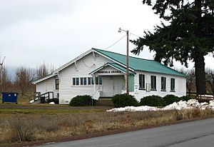
Parkdale grange hall
|
|

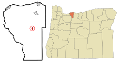
Location of Parkdale, Oregon
|
|
| Country | United States |
| State | Oregon |
| County | Hood River |
| Area | |
| • Total | 0.63 sq mi (1.62 km2) |
| • Land | 0.63 sq mi (1.62 km2) |
| • Water | 0.00 sq mi (0.00 km2) |
| Elevation | 1,788 ft (545 m) |
| Population
(2020)
|
|
| • Total | 299 |
| • Density | 477.64/sq mi (184.40/km2) |
| Time zone | UTC-8 (Pacific (PST)) |
| • Summer (DST) | UTC-7 (PDT) |
| ZIP code |
97041
|
| Area code(s) | 458 and 541 |
| FIPS code | 41-56500 |
| GNIS feature ID | 2409028 |
Parkdale is a small community in Hood River County, Oregon, United States. It is known as a census-designated place (CDP), which means it's a specific area used for collecting population data. In 2020, about 299 people lived there.
Contents
History of Parkdale
Parkdale was started in 1910 by David Eccles and R. J. McIsaac. It was built as the end point for the Mount Hood Railroad. This railroad helped connect the community to other places.
Where is Parkdale?
Parkdale is located in the middle of Hood River County. It sits in a beautiful area called the Upper Hood River Valley.
It is about 2 miles (3.2 km) southwest of a nearby community called Mount Hood. Parkdale is also about 16 miles (26 km) south of Hood River, which is the main town of the county. The main road that goes through Parkdale is Oregon Route 281.
The United States Census Bureau says that Parkdale covers a total area of about 0.63 square miles (1.6 square kilometers). All of this area is land.
Parkdale's Weather
Parkdale has a type of weather called a warm-summer Mediterranean climate. This means the summers are warm and dry, but not extremely hot. The average monthly temperatures usually stay below 71.6 °F (22 °C).
| Climate data for Parkdale | |||||||||||||
|---|---|---|---|---|---|---|---|---|---|---|---|---|---|
| Month | Jan | Feb | Mar | Apr | May | Jun | Jul | Aug | Sep | Oct | Nov | Dec | Year |
| Record high °F (°C) | 65 (18) |
66 (19) |
77 (25) |
83 (28) |
97 (36) |
99 (37) |
102 (39) |
101 (38) |
96 (36) |
87 (31) |
69 (21) |
62 (17) |
102 (39) |
| Mean daily maximum °F (°C) | 41.6 (5.3) |
45.4 (7.4) |
52.6 (11.4) |
58.8 (14.9) |
66.2 (19.0) |
72.7 (22.6) |
80.5 (26.9) |
80.8 (27.1) |
74.4 (23.6) |
62 (17) |
47.7 (8.7) |
39 (4) |
60.1 (15.6) |
| Mean daily minimum °F (°C) | 27.5 (−2.5) |
28.2 (−2.1) |
31.8 (−0.1) |
35.1 (1.7) |
40.1 (4.5) |
45 (7) |
48.8 (9.3) |
48.2 (9.0) |
42.7 (5.9) |
36.3 (2.4) |
31.5 (−0.3) |
26.2 (−3.2) |
36.8 (2.7) |
| Record low °F (°C) | −10 (−23) |
−13 (−25) |
10 (−12) |
21 (−6) |
24 (−4) |
28 (−2) |
34 (1) |
34 (1) |
15 (−9) |
10 (−12) |
−10 (−23) |
−13 (−25) |
−13 (−25) |
| Average precipitation inches (mm) | 5.7 (140) |
3.97 (101) |
3.39 (86) |
2.17 (55) |
1.5 (38) |
1.03 (26) |
0.33 (8.4) |
0.42 (11) |
0.91 (23) |
2.69 (68) |
6.07 (154) |
5.74 (146) |
33.92 (862) |
| Average snowfall inches (cm) | 15.1 (38) |
10.1 (26) |
3.9 (9.9) |
0.8 (2.0) |
0 (0) |
0 (0) |
0 (0) |
0 (0) |
0 (0) |
0.2 (0.51) |
6.7 (17) |
17.4 (44) |
54.2 (138) |
| Average precipitation days | 16 | 13 | 15 | 12 | 10 | 6 | 2 | 3 | 5 | 10 | 18 | 16 | 126 |
Geology and the Parkdale Lava Flow
The land around Parkdale is greatly shaped by Mount Hood. Mount Hood is a large stratovolcano (a cone-shaped volcano) located about 10 miles (16 km) south of the town.
There is a special lava flow in the area named after Parkdale. This lava flow is about 6,000 years old. It moved north from the Upper Hood River Valley, showing how powerful ancient volcanic activity was.
Population of Parkdale
| Historical population | |||
|---|---|---|---|
| Census | Pop. | %± | |
| 2020 | 299 | — | |
| U.S. Decennial Census | |||
In 2000, there were 266 people living in Parkdale. These people lived in 88 households, and 68 of those were families. The population density was about 419 people per square mile (162 people per square kilometer).
About 30.5% of the people were under 18 years old. About 10.9% were 65 years or older. The average age of people in Parkdale was 34 years old.
See also
 In Spanish: Parkdale (Oregón) para niños
 | Emma Amos |
 | Edward Mitchell Bannister |
 | Larry D. Alexander |
 | Ernie Barnes |


