
Sauvie Island facts for kids
|
Native name:
Wapato Island
|
|
|---|---|

Map of Sauvie Island
|
|

Sauvie Island
Location in Oregon
Sauvie Island (Oregon)
|
|
| Geography | |
| Location | Columbia River |
| Coordinates | 45°42′N 122°48′W / 45.7°N 122.8°W |
| Area | 32.75 sq mi (84.8 km2) |
| Administration | |
|
United States
|
|
| State | Oregon |
| Demographics | |
| Population | 1078 (2000) |
Sauvie Island is a very large island in the United States, located in the state of Oregon. It was originally called Wapato Island. It's the biggest island along the Columbia River, covering about 26,000 acres. This makes it one of the largest river islands in the entire country!
The island is about ten miles northwest of downtown Portland. It has the Columbia River to its east, the Multnomah Channel to its west, and the Willamette River to its south. A big part of the island is a special protected area called the Sauvie Island Wildlife Area. Sturgeon Lake is a major lake found in the northern part of the island. The total land area is about 32.75 square miles. Most of Sauvie Island is in Multnomah County, but the northern section is in Columbia County.
You can get to Sauvie Island by crossing the Sauvie Island Bridge over the Multnomah Channel. This bridge opened in June 2008, replacing an older bridge from 1950. The island was named after Laurent Sauvé, a French-Canadian who managed a dairy farm there a long time ago. Today, Sauvie Island is mostly covered in farms and wildlife areas. It's a popular spot for picking pumpkins, watching birds, and kayaking. Many people also enjoy cycling here because the roads are flat and not too busy. In 2000, about 1,078 people lived on the island year-round.
Contents
Exploring Sauvie Island's Past
Before Europeans arrived in the 1800s, Sauvie Island was home to the Multnomah band of the Chinook Tribe. They had around 15 villages on the island. About 2,000 people lived in large cedar log houses, which were about 30 yards long and 12 yards wide.
Key Dates in Sauvie Island History
- 1792 – A British explorer named Lieutenant William Robert Broughton visited the island. He named the northern tip "Warrior Point" because 23 canoes of armed Multnomah greeted his ship.
- October 29, 1792 – Lieutenant Broughton saw a tall, snowy mountain from the southern tip of Sauvie Island. He named it Mount Hood after a British admiral.
- November 4, 1805 – The famous Lewis and Clark team landed on the island. They called it "Wapato Island" because of the many "Indian potato" plants (also known as Broadleaf arrowhead) that grew there. These plants were a very important food source for the native people.
- Next Few Decades – Sadly, many native people on the island became sick from diseases like smallpox, measles, and tuberculosis.
- 1829 – A terrible sickness, called "the ague," spread across the land.
- 1832 – So many native people had passed away that there were very few left. Dr. McLoughlin from the Hudson's Bay Company moved the survivors and burned the old villages.
- 1834 – An American named Nathaniel Jarvis Wyeth built a small trading post called Fort William to compete with the British. It was abandoned in 1836.
- Around 1836 – The Hudson's Bay Company started dairy farms on the island. Laurent Sauvé, a French-Canadian employee, managed these farms, and the island was later named after him.
- 1843 – The opening of the Oregon Trail allowed many American settlers from the Midwest to come to the island.
- 1851 – A post office called "Mouth of Willamette" was set up. It was renamed "Souvies Island" the next year.
- 1858 – James Francis Bybee built the Bybee–Howell House. This historic house was added to the National Register of Historic Places in 1974 and is part of Howell Territorial Park.
- 1889 – The Warrior Rock Lighthouse was built at Warrior Point to help guide ships.
- 1920s – During a time called Prohibition, cargo ships from Canada would secretly drop off alcohol to smaller boats in the Columbia River. These smaller boats would then take the alcohol to Sauvie Island to meet people who would sell it illegally.
- 1930s – The Army Corps of Engineers built dikes to help control floods on the island.
- 1940s – The state of Oregon bought land to create the Sauvie Island Wildlife Area.
- November 29, 1943 – The Sauvie Island Conservation District was officially formed.
- December 30, 1950 – The first Sauvie Island Bridge opened. This meant the Sauvie Island Ferry, which was the last ferry in the Portland area, stopped running.
- 2006 – Construction began on a new Sauvie Island Bridge.
- 2008 – The new Sauvie Island Bridge opened with a parade and a special performance.
Fun on Sauvie Island's Beaches
Sauvie Island has some public beaches where you can relax and play. These include Walton Beach, North Unit Beach, and Collins Beach. They are all located on the island's east coast along NW Reeder Road.
The beaches are open from sunrise until 10:00 p.m. You can't stay overnight or camp there. Open fires are also not allowed. If you bring your dog, make sure it's on a leash. On warm, sunny days, these beaches can be lively and fun! Remember, you need a special Sauvie Island Wildlife Area parking permit to park your car at the beaches. You can buy these permits at stores on the island. If you don't have a permit, you might get a ticket.
Farms and Fresh Produce

Sauvie Island is famous for its many farms. There are nurseries, gardens, and about a dozen fruit and vegetable farms where you can pick your own produce! This is called "U-picking" or "Pick-Your-Own."
You can find all sorts of delicious crops, including:
- Strawberries
- Raspberries
- Marionberries
- Blackberries
- Blueberries
- Peaches
- Pears
- Sweet corn
- Cherries
- Broccoli
- Lettuce
- Cauliflower
- Zucchini
- Tomatoes
- Green beans
- Cucumbers
- Pumpkins
- Herbs
Besides picking fruits and vegetables, many farms also offer fun activities like hay rides, cow trains, pumpkin patches, and corn mazes. It's a great way to spend a day outdoors!
Images for kids
-
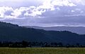
Looking west across the fields from Gillihan Road

