Multnomah Channel facts for kids
Quick facts for kids Multnomah Channel |
|
|---|---|

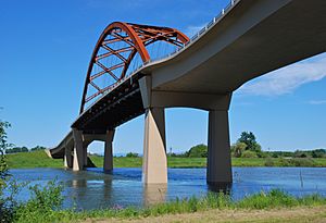
Passing under the Sauvie Island Bridge
|
|
|
Location of the mouth of the Multnomah Channel in Oregon
|
|
| Country | United States |
| State | Oregon |
| County | Multnomah and Columbia |
| Physical characteristics | |
| Main source | Willamette River Portland, Multnomah County 19 ft (5.8 m) 45°37′08″N 122°47′47″W / 45.61889°N 122.79639°W |
| River mouth | Columbia River St. Helens, Columbia County 8 ft (2.4 m) 45°51′30″N 122°47′36″W / 45.85833°N 122.79333°W |
| Length | 21.5 mi (34.6 km) |
The Multnomah Channel is a 21.5-mile (34.6 km) long waterway in Oregon, United States. It's a special kind of river branch called a distributary. This means it flows away from a main river instead of into it.
The channel starts from the Willamette River in Multnomah County. It then flows northwest and north around a large piece of land called Sauvie Island. Finally, it joins the mighty Columbia River near the city of St. Helens in Columbia County.
Long ago, Chinook people lived in villages along this channel. They were known as the Multnomahs. Today, the channel is a popular spot for fun activities like boating and fishing.
Contents
Where the Channel Flows
The Multnomah Channel is about one-third as wide as the main Willamette River. It is kept in place by dikes, which are like walls built to control water.
As the channel flows, it passes under the Sauvie Island Bridge. This bridge carries Northwest Sauvie Island Road. Several smaller streams also flow into the channel along its path.
About 8 miles (13 km) from where it meets the Columbia River, the channel flows around a place called Coon Island. Further along, it passes Louse Island. The channel then merges with Scappoose Bay before finally joining the Columbia River.
The Channel's Many Names
The Multnomah Channel has had many names throughout history. The United States Board on Geographic Names (USBGN) officially named it "Multnomah Channel" in 1913.
- In 1792, a European explorer named William Robert Broughton called it Calls River.
- Later, the famous explorers Lewis and Clark named it Wappato Inlet. They called Sauvie Island "Wappato Island."
- In the 1840s, a surveyor named Charles Wilkes called it Warrior Branch. This was because it met the Columbia River at Warrior Point.
- Before its current name, many people knew it as Willamette Slough.
The name "Multnomah" comes from the Chinook people who lived on Sauvie Island. They called themselves the Multnomahs. These people lived in villages with large longhouses along the channel. The area was perfect for growing a root vegetable called wapato and for finding fish and game.
Fun on the Water: Recreation
The Multnomah Channel is a great place for boats and even houseboats. There are many places to dock boats, called moorages, and marinas. Some of these places have public boat ramps where you can launch your boat for a fee.
- The Sauvie Island Public Boat Ramp is a popular spot.
- Hadley's Landing offers a place to tie up your boat and explore a trail.
A large part of the channel, especially along its right bank, is part of the Sauvie Island Wildlife Area. This area is a very important stopover for many different kinds of birds. You can reach it by boat from the Gilbert River Boat Ramp.
Near where the channel meets the Columbia River, you'll find several parks. These include Sand Island Marine Park, St. Helens Landing, Columbia View Park, and Scappoose Bay Landing.
Amazing Fish and Wildlife
The Multnomah Channel is a fantastic spot for fishing! It's especially known for its spring Chinook salmon. These salmon are big, often weighing around 18 pounds (8.2 kg), and some can even be as heavy as 40 pounds (18 kg)!
Besides salmon, you can also find other fish like sturgeon, walleye, shad, and brown bullhead catfish. There are also crayfish in the channel.
It's important to know that health advisories about eating fish from the lower Willamette River also apply to the Multnomah Channel. This is especially true for larger fish that live at the bottom of the river.
 | Georgia Louise Harris Brown |
 | Julian Abele |
 | Norma Merrick Sklarek |
 | William Sidney Pittman |


